Towns & cities · North West England
Chatburn
Chatburn — a village in Ribble Valley District, United Kingdom.

Wikimedia Commons contributors — see linked file page for photographer and licence licence
Plan your visit
- Typical visit
- 3 h–6 h
- Nearest railway station
- Clitheroe · 3.4 km
- Free entry
- Family-friendly
- Dog-friendly
About
Chatburn is a town, city, village or settlement in the United Kingdom. Recent population estimates put it at around 1,102 people. Wikidata describes it as: "a village in Ribble Valley District, United Kingdom". Coordinates: 53.8960°, -2.3590°.
Photo gallery
Protected designations
- Area of Outstanding Natural Beauty: Forest Of Bowland
Designations sourced from Natural England open data under OGL v3.
From the Wikipedia article
Chatburn is a village, civil parish and electoral ward in the Ribble Valley, East Lancashire, England. The population of the civil parish at the 2011 census was 1,102. Situated in a hollow between two ridges north-east of Clitheroe, just off the A59 road, relatively near Pendle Hill south-east of the village. Lanehead quarry is situated to the West at the termination of Chatburn Old Road. Ribble lane at 240 above sea level leads down to the River Ribble North of the village, the top of Downham road being 150 feet higher. The parish adjoins the Ribble Valley parishes of Grindleton, Sawley, Rimington, Downham, Worston, Clitheroe and West Bradford.
Excerpt from Wikipedia under CC BY-SA 4.0. See the source article linked in Sources below.
Background
History
The village itself can be dated back to Anglo-Saxon times; it takes its name (as does the lowest Avenue) from one of the most distinguished characters of that time, St Chad, and having a brook (or burn) hence the name. The village sits outside the Forest of Bowland and was never considered part of the ancient Lordship of Bowland. A feature of the village is the spire of the parish church, which was erected around 1838. The steeple was struck by lightning in 1854, but was rebuilt in the same year. Over the years Chatburn has had several mills, one had a large brick chimney, the site is now houses on both sides of Ribble Lane. Early in the 15th century there was a watermill. Chatburn railway…
Sourced from Wikipedia under CC BY-SA 4.0.
- Coordinates
- 53.8960, -2.3590
- County
- Lancashire
- District
- Ribble Valley
- Parish
- Chatburn
- Postcode
- BB7 4AN
- Parliamentary constituency
- Pendle and Clitheroe
- Population
- 1,102
- Nearest railway station
- Clitheroe — 3.4 km
Sources
- wikidata: Q677309 (CC0)
- wikipedia: Chatburn (CC BY-SA 4.0)
- commons: Chatburn - geograph.org.uk - 38576.jpg (CC BY-SA 4.0)
Other places nearby
Loading nearby places…
Nearby
 📷 3
📷 3Historic churches · North West England
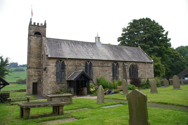
Christ Church, Chatburn
Christ Church, Chatburn — grade II listed church in Chatburn, Ribble Valley, Lancashire, England, UK.
 📷 3
📷 3Historic churches · North West England
St Ambrose's Church, Grindleton
St Ambrose's Church, Grindleton — grade II listed church in Grindleton, Ribble Valley, Lancashire, England, UK.
 📷 3
📷 3Abbeys & priories · North West England
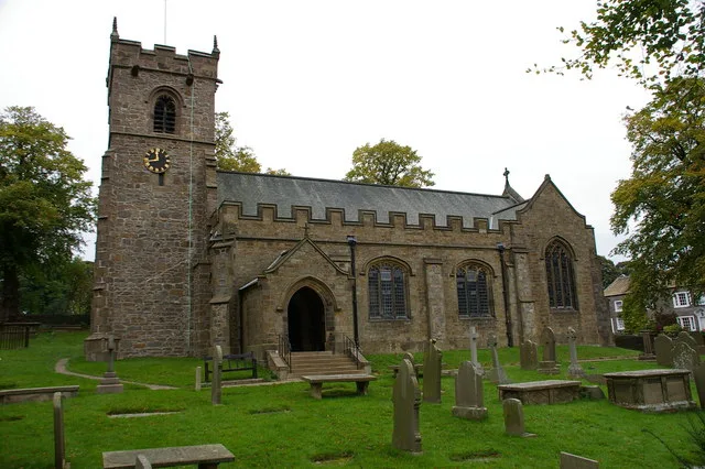
St Leonard's Church, Downham
St Leonard's Church, Downham — Grade II* listed church in Downham, Lancashire, England, UK.
 Flagship📷 4
Cathedrals · North West England
St Leonard's Church, Downham
St Leonard's Church, Downham is a cathedral in the United Kingdom.
 📷 3
📷 3Wildlife reserves · North West England
Salthill Quarry
Salthill Quarry — nature reserve in Lancashire, England.
 📷 3
📷 3Historic houses · North West England
Old Well Hall
Old Well Hall — Grade II* listed house in Downham, Lancashire, England, UK.
More towns in this region
 Flagship📷 5
Towns & cities · North West England
Aughton
Aughton — village and civil parish within the West Lancashire district of Lancashire, England.
 Flagship📷 5
Towns & cities · North West England
Haigh
Haigh — village and civil parish of the Metropolitan Borough of Wigan in Greater Manchester, England.
 Flagship📷 5
Towns & cities · North West England
Lancaster
Lancaster — county town of Lancashire, England.
 Flagship📷 3
Towns & cities · North West England
Preston
Preston — city and the administrative centre of Lancashire, England.
Frequently asked questions
- Where is Chatburn?
- Chatburn is in Lancashire, North-West England, United Kingdom (postcode BB7 4AN), in the parish of Chatburn.
- Is Chatburn a protected site?
- Yes — Chatburn is part of the Forest Of Bowland National Landscape (AONB).
- Is Chatburn free to visit?
- Yes, Chatburn is free to enter.
- How do I get to Chatburn?
- The nearest railway station is Clitheroe, about 3.4 km away. Drivers can navigate to postcode BB7 4AN.