Reservoirs & lochs · East Midlands
Woodhead Reservoir
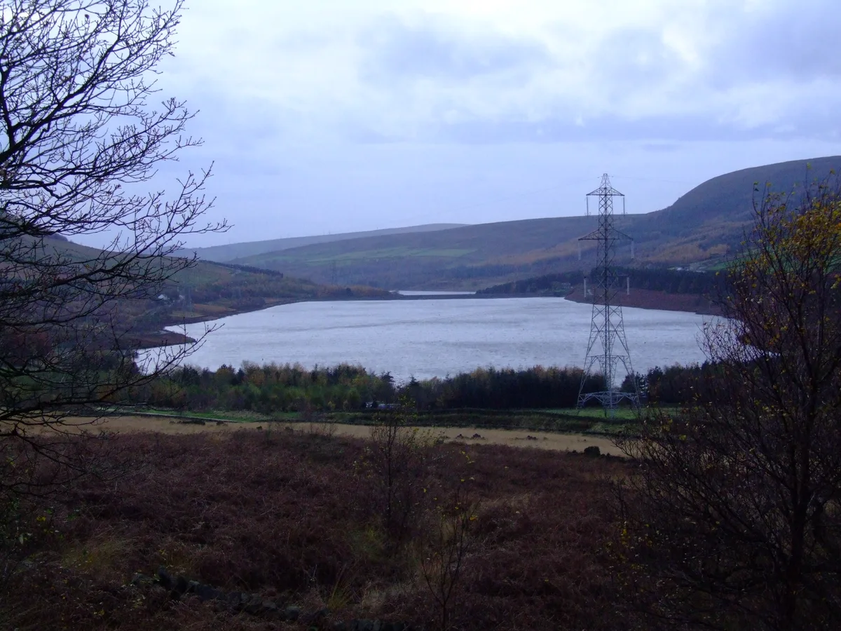
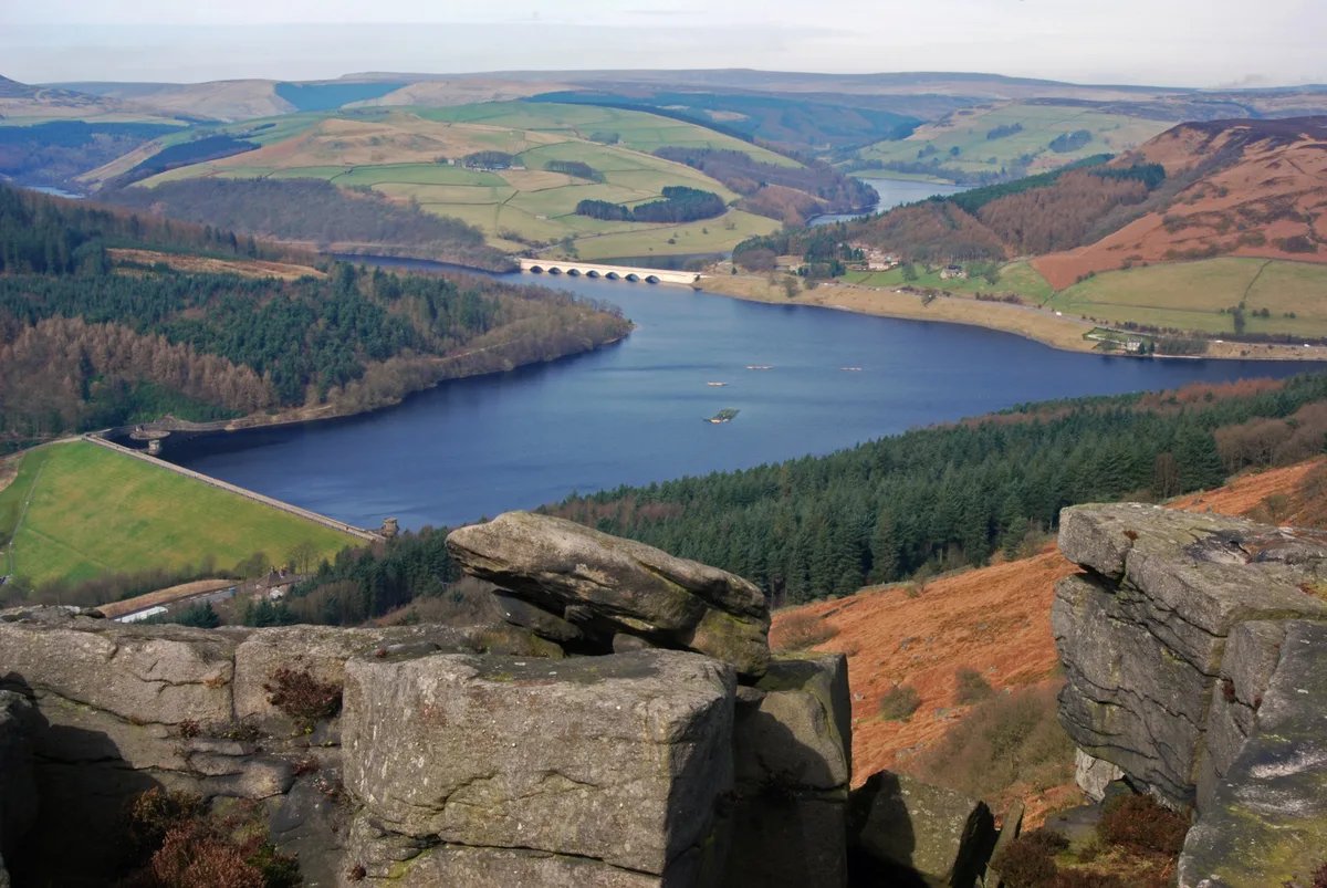
Woodhead Reservoir — reservoir in Derbyshire, England, UK.

Wikimedia Commons contributors — see linked file page for photographer and licence licence
Plan your visit
- Typical visit
- 1 h–2.5 h
- Nearest railway station
- Manor Station · 7.0 km
- Free entry
- Dog-friendly
About
Woodhead Reservoir is a reservoir in the United Kingdom. Managed by Manchester Corporation Water Works. Part of Longdendale Chain. Wikidata describes it as: "reservoir in Derbyshire, England, UK". Coordinates: 53.4936°, -1.8682°.
Photo gallery
Protected designations
- Site of Special Scientific Interest: Dark Peak SSSI
Designations sourced from Natural England open data under OGL v3.
From the Wikipedia article
Woodhead reservoir is a man-made lake near the hamlet of Woodhead in Longdendale in north Derbyshire, England. It was constructed by John Frederick Bateman between 1847 and June 1877 as part of the Longdendale Chain of reservoirs to supply water from the River Etherow to the urban areas of Greater Manchester. It is at the top of the chain of reservoirs and was the first to be started, though, due to construction problems, it was the last to be completed.
Excerpt from Wikipedia under CC BY-SA 4.0. See the source article linked in Sources below.
Background
Architecture
The construction of the Woodhead Embankment was ambitious and fraught with difficulties. The embankment was to be about 90 ft in height; it was sealed to the underlying impermeable rock by a central impermeable clay puddle core or curtain. This was supported on each side by selected strong earth material, and then gravel to form a slope of 1 in 1 upstream and 1 in 2 downstream. The upstream would be pitched, and faced in stone. The turnpike would pass over the crest. Drinking water would be extracted by means of a tunnel from several metres below the water level, while when full, excess water would pass over the overspill or waste weir.
Description
Work started in 1848. The Heyden Viaduct, now known as the Woodhead Bridge, was completed in 1851, and turned over to the Salters Brook turnpike road that year. The Woodhead embankment was 20 ft from completion. Discharge valves had been supplied by Messrs Armstrong and Co, of Newcastle upon Tyne. There was some leakage but on 10 May 1854 the Woodhead Reservoir was declared complete, with the exception of remedying the leak. To stop the leak, borings had been made, and ash injected under pressure in the hope it would act as a sealant. In 1858, it was concluded that this would not work; the Etherow valley was on multiple fissures relating to a fault that was causing movement in the soft beds…
Sourced from Wikipedia under CC BY-SA 4.0.
- Coordinates
- 53.4936, -1.8682
- County
- Derbyshire
- District
- High Peak
- Parish
- Tintwistle
- Postcode
- SK13 1JA
- Parliamentary constituency
- High Peak
- Nearest railway station
- Manor Station — 7 km
Sources
- wikidata: Q7338066 (CC0)
- wikipedia: Woodhead Reservoir (CC BY-SA 4.0)
- commons: WoodheadreservoirDerbyshire.jpg (CC BY-SA 4.0)
Other places nearby
Loading nearby places…
Nearby
Campsites · East Midlands
Crowden Campsite
Crowden Campsite — a campsite in england east midlands.
 📷 3
📷 3Historic bridges · East Midlands
Crowden Bridge 200 yards north west of Crowden Old Vicarage
Crowden Bridge 200 yards north west of Crowden Old Vicarage — Grade II listed building-listed bridge in england-east-midlands, United Kingdom.
Hostels · East Midlands
Crowden Outdoor Education Centre
Crowden Outdoor Education Centre — a hostel in england east midlands.
 📷 5
📷 5Reservoirs & lochs · East Midlands
Longdendale Chain
Longdendale Chain — group of reservoirs in Derbyshire, England, UK.
 📷 3
📷 3Reservoirs & lochs · East Midlands
Torside Reservoir
Torside Reservoir — reservoir in Derbyshire, England, UK.
 📷 3
📷 3Memorials & monuments · East Midlands
Blenheim L1476 memorial
Blenheim L1476 memorial — a memorial in england-east-midlands, United Kingdom.
More places run by Manchester Corporation Water Works
 📷 5
📷 5Reservoirs & lochs · East Midlands
Arnfield Reservoir
Arnfield Reservoir — reservoir in Derbyshire, England, UK.
 📷 3
📷 3Reservoirs & lochs · East Midlands
Bottoms Reservoir
Bottoms Reservoir — reservoir in Derbyshire, England, UK.
 📷 3
📷 3Reservoirs & lochs · East Midlands
Hollingworth Reservoir
Hollingworth Reservoir — former reservoir in Derbyshire/Greater Manchester, England, UK.
 📷 3
📷 3Reservoirs & lochs · East Midlands
Rhodeswood Reservoir
Rhodeswood Reservoir — reservoir in Derbyshire, England, UK.
More places in this region
 Flagship📷 5
Reservoirs & lochs · East Midlands
Ladybower Reservoir
Ladybower Reservoir — reservoir in Derbyshire, England.
 📷 3
📷 3Reservoirs & lochs · East Midlands
Toddbrook Reservoir
Toddbrook Reservoir — reservoir in Derbyshire, England, UK.
 📷 3
📷 3Reservoirs & lochs · East Midlands
Agden Reservoir
Agden Reservoir — reservoir in South Yorkshire, England, UK.
 📷 3
📷 3Reservoirs & lochs · East Midlands
Blackbrook Reservoir
Blackbrook Reservoir — reservoir and Site of Special Scientific Interest in Leicestershire, United Kingdom.
Frequently asked questions
- Where is Woodhead Reservoir?
- Woodhead Reservoir is in Derbyshire, the East Midlands, United Kingdom (postcode SK13 1JA), in the parish of Tintwistle.
- Who runs Woodhead Reservoir?
- Woodhead Reservoir is operated by Manchester Corporation Water Works.
- Is Woodhead Reservoir a protected site?
- Yes — Woodhead Reservoir is part of the Dark Peak SSSI Site of Special Scientific Interest.
- How do I get to Woodhead Reservoir?
- The nearest railway station is Manor Station, about 7.0 km away. Drivers can navigate to postcode SK13 1JA.