Reservoirs & lochs · North West England
Ward's Reservoir
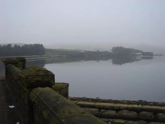
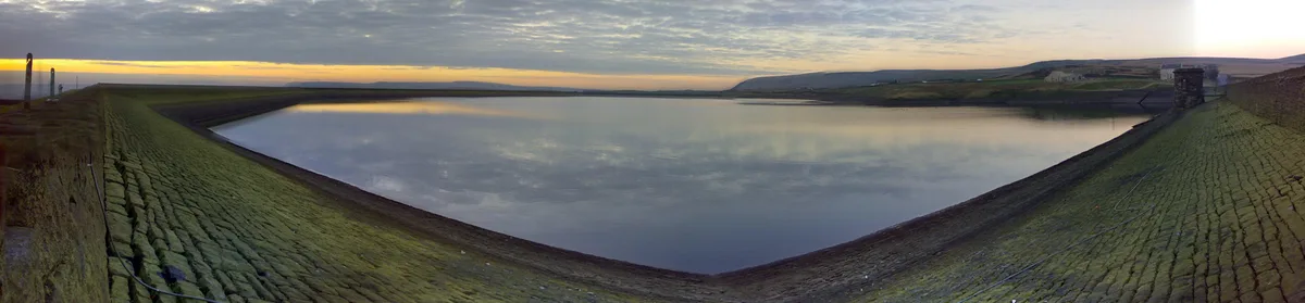
Ward's Reservoir — reservoir in Lancashire, England, UK.

Wikimedia Commons contributors — see linked file page for photographer and licence licence
Plan your visit
- Typical visit
- 1 h–2.5 h
- Nearest railway station
- Entwistle · 6.0 km
- Free entry
- Dog-friendly
About
Ward's Reservoir is a reservoir in the United Kingdom. Wikidata describes it as: "reservoir in Lancashire, England, UK". Coordinates: 53.6381°, -2.5006°.
Photo gallery
Protected designations
- Site of Special Scientific Interest: West Pennine Moors SSSI
Designations sourced from Natural England open data under OGL v3.
From the Wikipedia article
Ward's Reservoir (or Wards Reservoir), known locally as the Blue Lagoon, is a small reservoir close to the village of Belmont, Lancashire, England. It is in the West Pennine Moors north of Bolton. The reservoir did not supply drinking water but was built to supply water to Rycroft Works in the early 19th century. It was enlarged in 1893 by Deacons who used the water to supply Belmont Bleachworks. It holds 150,000 cubic metres of water, with a surface area of 28,000 square metres, when full. Most of the reservoir is only a few feet deep, but it has a depth of about 80 feet (24 m) at its deepest point. The reservoir was drained by its owner, Belmont Holdings, in 2010, despite efforts by local residents to save it. It had fallen into a state of disrepair following the closure of the bleachworks, and was considered a flood risk by the Environment Agency. By the end of August 2010 heavy rain had refilled the reservoir, and in September 2010 it was sold for £50,000. The buyer is thought to be a Horwich-based consortium who will renovate and develop the reservoir for recreational use.
Excerpt from Wikipedia under CC BY-SA 4.0. See the source article linked in Sources below.
- Coordinates
- 53.6381, -2.5006
- District
- Blackburn with Darwen
- Parish
- North Turton
- Postcode
- BL7 8AD
- Parliamentary constituency
- Rossendale and Darwen
- Nearest railway station
- Entwistle — 6 km
Sources
- wikidata: Q7362956 (CC0)
- wikipedia: Ward's Reservoir (CC BY-SA 4.0)
- commons: Ward's Reservoir - geograph.org.uk - 1091712.jpg (CC BY-SA 4.0)
Other places nearby
Loading nearby places…
Nearby
 📷 3
📷 3Reservoirs & lochs · North West England
Belmont Reservoir
Belmont Reservoir — reservoir in Lancashire, England.
 📷 5
📷 5Natural landmarks · North West England
Winter Hill
Winter Hill — mountain in United Kingdom.
 📷 5
📷 5Mountains & hills · North West England
Winter Hill
Winter Hill — Named summit at 456 m.
 📷 4
📷 4Memorials & monuments · North West England
Winter Hill Air Disaster
Winter Hill Air Disaster — a memorial in england-north-west, United Kingdom.
 📷 5
📷 5Memorials & monuments · North West England
Scotsman Post
Scotsman Post — a memorial in england-north-west, United Kingdom.
 📷 3
📷 3Historic houses · North West England
Higher Hempshaw's Ruins
Higher Hempshaw's Ruins — a historic house in england-north-west, United Kingdom.
More places in this region
 Flagship📷 5
Reservoirs & lochs · North West England
Yarrow Reservoir
Yarrow Reservoir — reservoir in Lancashire, England, UK.
.jpg?width=1200) 📷 3
📷 3Reservoirs & lochs · North West England
Abbey Village Reservoir
Abbey Village Reservoir — reservoir in Lancashire, England, UK.
 📷 3
📷 3Reservoirs & lochs · North West England
Anglezarke Reservoir
Anglezarke Reservoir — reservoir in Lancashire, England, UK.
 📷 3
📷 3Reservoirs & lochs · North West England
Ashworth Moor Reservoir
Ashworth Moor Reservoir — reservoir in Greater Manchester, England, UK.
Frequently asked questions
- Where is Ward's Reservoir?
- Ward's Reservoir is in North-West England, United Kingdom (postcode BL7 8AD), in the parish of North Turton.
- Is Ward's Reservoir a protected site?
- Yes — Ward's Reservoir is part of the West Pennine Moors SSSI Site of Special Scientific Interest.
- How do I get to Ward's Reservoir?
- The nearest railway station is Entwistle, about 6.0 km away. Drivers can navigate to postcode BL7 8AD.