Mountains & hills · North West England
Winter Hill
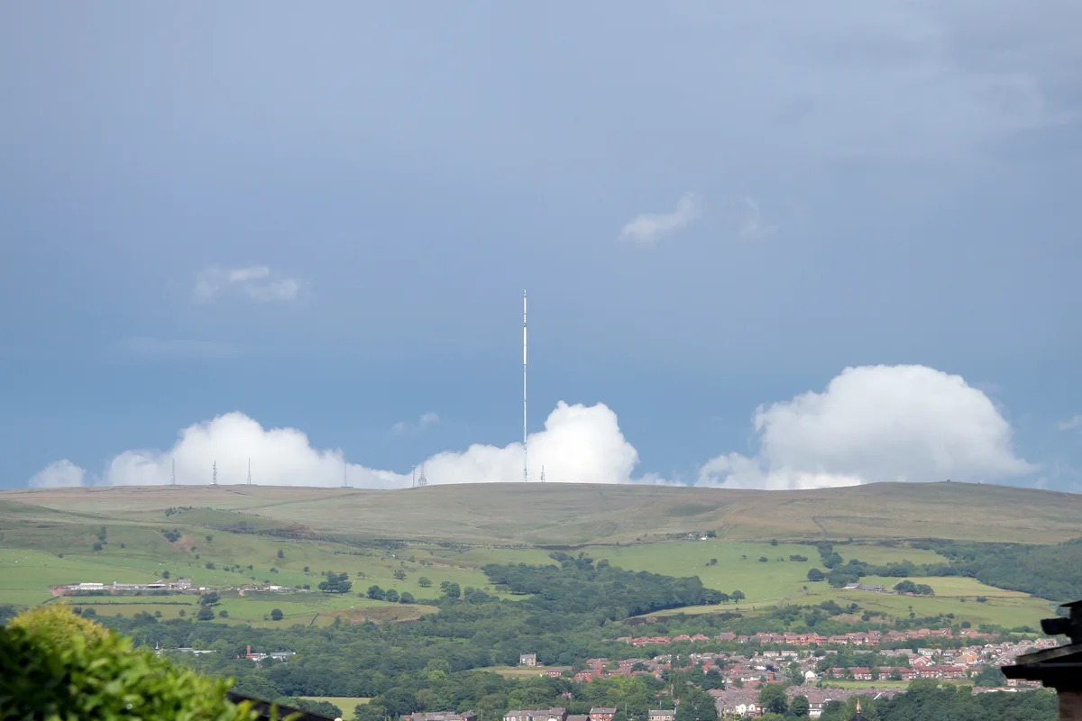
Winter Hill — Named summit at 456 m.

Wikimedia Commons contributors — see linked file page for photographer and licence licence
Plan your visit
- Typical visit
- 3 h–8 h
- Best time of year
- Late spring – early autumn (May–Oct)
- Nearest railway station
- Blackrod · 5.6 km
- Free entry
- Dog-friendly
About
Winter Hill is a named summit in the United Kingdom. Wikidata describes it as: "Named summit at 456 m.". Coordinates: 53.6298°, -2.5159°.
Photo gallery
Protected designations
- Site of Special Scientific Interest: West Pennine Moors SSSI
Designations sourced from Natural England open data under OGL v3.
From the Wikipedia article
Winter Hill is a hill on which the three boroughs of Chorley, Blackburn with Darwen and Bolton meet in North West England. It is located on Rivington Moor, Chorley and is 1,496 feet (456 m) high. Part of the West Pennine Moors, it is a popular walking area, and has been the site of mining activity, aeroplane disasters and a murder. Its prominent position made it the ideal site for the Winter Hill TV Mast, transmitting to a large part of North West England. There is also a number of other telecommunication masts and towers around the summit and side of the hill for mobile phones, Professional Mobile Radio users and emergency services. Lancashire Constabulary was the first to use the site for one of their base stations in 1950; they had to build the road and it is said to have been built by policemen. Paths to the summit lead from Belmont (in Blackburn with Darwen), Rivington (in Chorley), and Horwich and Blackrod (in Bolton). The summit can also be reached via a short walk from the top of a road pass 1+1⁄4 miles (2 km) west of Belmont. The hill is a prominent natural landmark on the skyline for the most of Chorley and further afield. Winter Hill's topographic prominence results in it being classified as a Marilyn. The trig point on its summit marks the highest point in Blackburn with Darwen whereas the highest point in Bolton is 440 yards (400 m) away on its south east slope at 1,467 feet (447 m) above sea level. It provides views over Lancashire, Cheshire, Merseyside and Greater Manchester, including Manchester city centre, Salford, Werneth Low, Wigan and Bolton. In clear weather conditions, locations such as Blackpool Tower, the Dream in Sutton, St Helens, Jodrell Bank Observatory, Snaefell in the Isle of Man, the Cumbrian mountains, Liverpool, Southport, the Irish Sea, the Pennines and much of the North West of England, can be seen. On a clear day, views from the summit include four national parks: the Lake District, Yorkshire Dales, Peak District and Snowdonia…
Excerpt from Wikipedia under CC BY-SA 4.0. See the source article linked in Sources below.
Background
History
The bare hilltop was once covered by woodland that may have been destroyed by fire and it is thought that the hill was once inhabited, though no remains have been found. There is a Bronze Age round cairn dating from 1600–1400 BC on the hill. In 1883, a local historian recorded the old name for Winter Hill as Edgar Hill, named in connection to Saxon King Edgar
Sourced from Wikipedia under CC BY-SA 4.0.
- Coordinates
- 53.6298, -2.5159
- District
- Blackburn with Darwen
- Parish
- North Turton
- Postcode
- BL7 8BA
- Parliamentary constituency
- Rossendale and Darwen
- Nearest railway station
- Blackrod — 5.6 km
Sources
- osm: n872428124 (ODbL)
- wikipedia: Winter Hill (North West England) (CC BY-SA 4.0)
- commons: Winter Hill From Blackrod.jpg (CC BY-SA 4.0)
Featured in this guide
Other places nearby
Loading nearby places…
Nearby
 📷 5
📷 5Natural landmarks · North West England
Winter Hill
Winter Hill — mountain in United Kingdom.
 📷 4
📷 4Memorials & monuments · North West England
Winter Hill Air Disaster
Winter Hill Air Disaster — a memorial in england-north-west, United Kingdom.
 📷 5
📷 5Memorials & monuments · North West England
Scotsman Post
Scotsman Post — a memorial in england-north-west, United Kingdom.
 📷 3
📷 3Memorials & monuments · North West England
Noon Hill
Noon Hill is a memorial in the United Kingdom.
 📷 3
📷 3Reservoirs & lochs · North West England
Ward's Reservoir
Ward's Reservoir — reservoir in Lancashire, England, UK.
 📷 3
📷 3Historic houses · North West England
Higher House
Higher House — a historic house in england-north-west, United Kingdom.
More mountains in this region
 📷 3
📷 3Mountains & hills · North West England
Allen Crags
Allen Crags — Named summit at 785 m.
 📷 3
📷 3Mountains & hills · North West England
Alum Pot
Alum Pot — Open shaft pothole in North Yorkshire.
 📷 3
📷 3Mountains & hills · North West England
Arnside Knott
Arnside Knott — Named summit at 159 m.
 📷 3
📷 3Mountains & hills · North West England
Aye Gill Pike
Aye Gill Pike — Named summit at 556.3 m.
Frequently asked questions
- Where is Winter Hill?
- Winter Hill is in North-West England, United Kingdom (postcode BL7 8BA), in the parish of North Turton.
- Is Winter Hill a protected site?
- Yes — Winter Hill is part of the West Pennine Moors SSSI Site of Special Scientific Interest.
- Is Winter Hill free to visit?
- Yes, Winter Hill is free to enter.
- How do I get to Winter Hill?
- The nearest railway station is Blackrod, about 5.6 km away. Drivers can navigate to postcode BL7 8BA.