Natural landmarks · Mid Wales
Tarren y Gesail
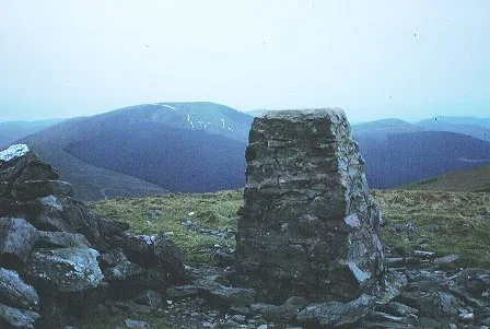
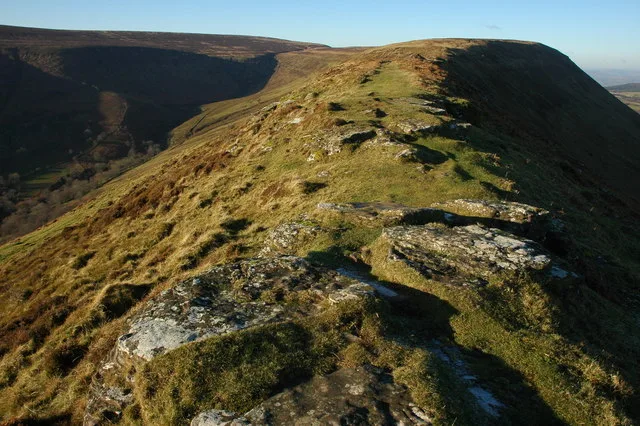
Tarren y Gesail — mountain (667m) in Gwynedd.

Wikimedia Commons contributors — see linked file page for photographer and licence licence
Plan your visit
- Typical visit
- 1 h–2 h
- Nearest railway station
- Nant Gwernol · 3.1 km
- Free entry
- Dog-friendly
About
Tarren y Gesail is a named natural landmark in the United Kingdom. Part of Cadair Idris. Wikidata describes it as: "mountain (667m) in Gwynedd". Coordinates: 52.6354°, -3.9069°.
Photo gallery
From the Wikipedia article
Tarren y Gesail is a mountain in Snowdonia, north Wales. It is one of the Marilyns of the Cadair Idris group. Lying to the south of Cadair Idris, it and its neighbour Tarrenhendre form the bulk of the Tarren subgroup. The Tarrens rise from the south shore of the Llyn Mwyngil (Tal-y-llyn Lake) and end at the Dyfi estuary. The summit is a grassy ridge, which has a cairn and trig point. The views are extensive to the south and east, with Plynlimon and Cardigan Bay ahead, while the north views are dominated by Cadair Idris and Maesglase to the west. Between Tarren y Gesail and Tarren Hendre lies the Bryn Eglwys quarry, and Nant Gwernol railway station on the Talyllyn Railway, in the ravine of the Nant Gwernol stream. The Tarrens can be thought of as forgotten mountains of Snowdonia, overshadowed by the popularity of Cadair Idris, occupying the sleepy south-western frontier of the national park.
Excerpt from Wikipedia under CC BY-SA 4.0. See the source article linked in Sources below.
- Coordinates
- 52.6354, -3.9069
- Address
- Snowdonia, Wales
- Nearest railway station
- Nant Gwernol — 3.1 km
Sources
- wikidata: Q7686694 (CC0)
- wikipedia: Tarren y Gesail (CC BY-SA 4.0)
- commons: Tarren y Gesail. - geograph.org.uk - 136700.jpg (CC BY-SA 4.0)
Other places nearby
Loading nearby places…
Nearby
 📷 3
📷 3Mountains & hills · Mid Wales
Tarren y Gesail
Tarren y Gesail — Named summit at 667 m.
 📷 4
📷 4Other places · Mid Wales
Bryn Eglwys
Bryn Eglwys in Wales Mid, United Kingdom.
 📷 3
📷 3Historic houses · Mid Wales
Upper Dressing Sheds
Upper Dressing Sheds — a historic house in wales-mid, United Kingdom.
 📷 3
📷 3Mountains & hills · Mid Wales
Foel Pandy
Foel Pandy — a mountain in wales-mid, United Kingdom, 454 m.
 📷 3
📷 3Mountains & hills · Mid Wales
Mynydd Rhyd-galed East Top
Mynydd Rhyd-galed East Top — a mountain in wales-mid, United Kingdom, 475 m.
Mountain bike trails · Mid Wales
Slab Track
Slab Track — a mtb trail in wales mid.
More natural landmarks in this region
 Flagship📷 3
Natural landmarks · Mid Wales
Bomere Pool
Bomere Pool — lake in Shropshire, England, UK.
 📷 3
📷 3Natural landmarks · Mid Wales
Craig-y-llyn
Craig-y-llyn — mountain (622m) in Gwynedd, Wales.
 📷 3
📷 3Natural landmarks · Mid Wales
Bache Hill
Bache Hill — mountain (610m) in Powys.
 📷 3
📷 3Natural landmarks · Mid Wales
Black Hill
Black Hill — mountain in Herefordshire, England, United Kingdom.
Frequently asked questions
- Where is Tarren y Gesail?
- Tarren y Gesail is in Mid Wales, United Kingdom.
- Is Tarren y Gesail free to visit?
- Yes, Tarren y Gesail is free to enter.
- How do I get to Tarren y Gesail?
- The nearest railway station is Nant Gwernol, about 3.1 km away.