Mountains & hills · Mid Wales
Mynydd Rhyd-galed East Top
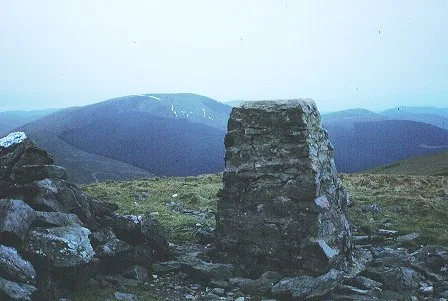
Mynydd Rhyd-galed East Top — a mountain in wales-mid, United Kingdom, 475 m.

Richard Law — CC BY-SA 2.0 via Wikimedia Commons licence
Plan your visit
- Typical visit
- 3 h–8 h
- Best time of year
- Late spring – early autumn (May–Oct)
- Free entry
- Dog-friendly
About
Mynydd Rhyd-galed East Top is a named summit in wales-mid, United Kingdom, with an elevation of approximately 475 metres. Listed in the Wikidata register of UK peaks; see the Wikipedia article for further details on the mountain's location, geology and walking routes.
Photo gallery
Place summary
Mynydd Rhyd-galed East Top is a mountain located in Mid Wales. It is part of the Mynydd Rhyd-galed range, known for its rugged terrain and natural beauty.
AI-generated from the structured facts on this page (operator, designation, listing, era). Not a substitute for visiting.
- Coordinates
- 52.6195, -3.9177
- District
- Gwynedd
- Parish
- Pennal
- Postcode
- SY20 9LF
- Parliamentary constituency
- Dwyfor Meirionnydd
Sources
- wikidata: Q106709729 (CC0)
Other places nearby
Loading nearby places…
Nearby
 📷 3
📷 3Historic houses · Mid Wales
Upper Dressing Sheds
Upper Dressing Sheds — a historic house in wales-mid, United Kingdom.
 📷 4
📷 4Other places · Mid Wales
Bryn Eglwys
Bryn Eglwys in Wales Mid, United Kingdom.
 📷 3
📷 3Natural landmarks · Mid Wales
Tarren y Gesail
Tarren y Gesail — mountain (667m) in Gwynedd.
 📷 3
📷 3Mountains & hills · Mid Wales
Tarren y Gesail
Tarren y Gesail — Named summit at 667 m.
 📷 3
📷 3Mountains & hills · Mid Wales
Tarrenhendre
Tarrenhendre — Named summit at 634 m.
 📷 3
📷 3Historic houses · Mid Wales
Lower dressing sheds
Lower dressing sheds — a historic house in wales-mid, United Kingdom.
More mountains in this region
 📷 3
📷 3Mountains & hills · Mid Wales
Black Hill
Black Hill — Named summit at 640 m.
 📷 3
📷 3Mountains & hills · Mid Wales
Black Mixen
Black Mixen — Named summit at 650 m.
 📷 5
📷 5Mountains & hills · Mid Wales
Cadair Idris
Cadair Idris — Named summit at 893 m.
 📷 3
📷 3Mountains & hills · Mid Wales
Caer Caradoc
Caer Caradoc — Named summit at 459 m.
Frequently asked questions
- Where is Mynydd Rhyd-galed East Top?
- Mynydd Rhyd-galed East Top is in Mid Wales, United Kingdom (postcode SY20 9LF), in the parish of Pennal.
- Is Mynydd Rhyd-galed East Top free to visit?
- Yes, Mynydd Rhyd-galed East Top is free to enter.
- How do I get to Mynydd Rhyd-galed East Top?
- Drivers can navigate to postcode SY20 9LF. It sits within the Dwyfor Meirionnydd parliamentary constituency.