Towns & cities · West Midlands
Stanton
Stanton — village in Tewkesbury Borough, Gloucestershire, England.

Wikimedia Commons contributors — see linked file page for photographer and licence licence
Plan your visit
- Typical visit
- 3 h–6 h
- Nearest railway station
- Toddington · 2.9 km
- Free entry
- Family-friendly
- Dog-friendly
About
Stanton is a town, city, village or settlement in the United Kingdom. Recent population estimates put it at around 189 people. Address: WR12. Wikidata describes it as: "village in Tewkesbury Borough, Gloucestershire, England". Coordinates: 52.0064°, -1.8968°.
Photo gallery
Protected designations
- Area of Outstanding Natural Beauty: Cotswolds
Designations sourced from Natural England open data under OGL v3.
From the Wikipedia article
Stanton is a village and civil parish in Tewkesbury Borough, Gloucestershire, England. The village is a spring line settlement at the foot of the Cotswold escarpment, about 2.5 miles (4 km) southwest of Broadway in neighbouring Worcestershire. Broadway is Stanton's postal town. The 2011 Census recorded the parish's population as 198. The parish is about 3 miles (5 km) long on a northwest – southeast axis, embracing both low-lying land northwest of the village and high Cotswold land to the southeast. On the opposite northeast – southwest axis the parish is about 1.5 miles (2.4 km) across at its widest point. Its highest point is Shenberrow Hill on the escarpment in the southeast of the parish, 994 feet (303 m) above sea level. The low-lying northwestern part of the parish is bounded mostly by two streams, which converge and then join the River Isbourne about 0.5 miles (800 m) outside the parish. A report in 1712 indicated that the village consisted of 60 houses and 300 inhabitants, including 29 freeholders. Much of the area of the village was owned by the Stott family from 1906 to 1949. In addition to restoring the properties, these owners built a reservoir in 1907, added lighting to the main street, improved the church, extended the school, built a swimming pool and cricket field. Today, the village has no school, post office or shops. The village is built almost completely of Cotswold stone, a honey-coloured Jurassic limestone. Several cottages have thatched roofs. It has a high street, with a pub, The Mount, at the end. David Verey calls it "architecturally, the most distinguished of the smaller villages in the North Cotswolds". The Daily Telegraph described Stanton in 2017 as "arguably the most beautiful Cotswold village of them all" while the Huffington Post said that it's "one of the prettiest and idyllic unspoilt villages of the Cotswolds". The Cotswold Way long-distance footpath passes through the village.
Excerpt from Wikipedia under CC BY-SA 4.0. See the source article linked in Sources below.
Background
History
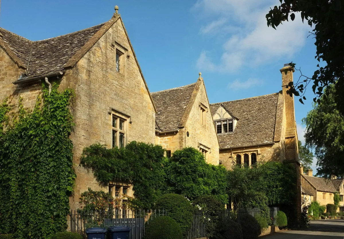
The Manor (also known as Warren House) and Warne Cottage, also called Warren House, is Elizabethan, with the year 1577 on a datestone. This was formerly manor house, and is now one house and an attached cottage. Old Manor Farmhouse, built circa 1678, is also Elizabethan. A full 43 of the buildings in this village are Listed, all as Grade II. Some of the noteworthy properties include the following.
Description
Though not listed, this very quaint 17th-century inn, atop a steep hill at the end of the village, is a popular spot for tourists because of its views over the Vale of Evesham and the Malvern Hills to the Black Mountains in Wales. It has an interesting history. The building was originally a farmhouse,
Sourced from Wikipedia under CC BY-SA 4.0.
- Coordinates
- 52.0064, -1.8968
- County
- Gloucestershire
- District
- Tewkesbury
- Parish
- Stanton
- Postcode
- WR12
- Parliamentary constituency
- Tewkesbury
- Population
- 189
- Nearest railway station
- Toddington — 2.9 km
- Official site
- www.gloucestershire.gov.uk
Sources
- wikidata: Q635247 (CC0)
- wikipedia: Stanton, Gloucestershire (CC BY-SA 4.0)
- commons: Stanton church, Gloucestershire - geograph.org.uk - 991331.jpg (CC BY-SA 4.0)
Other places nearby
Loading nearby places…
Nearby
 📷 3
📷 3Historic churches · West Midlands
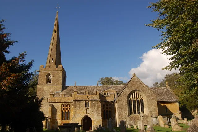
Church of St Michael and All Angels, Stanton
Church of St Michael and All Angels, Stanton — historic church in Stanton, Tewkesbury, Gloucestershire, England, United Kingdom.
 📷 3
📷 3Memorials & monuments · West Midlands
War Memorial in Garden Wall to Stanton Court
War Memorial in Garden Wall to Stanton Court — Grade II listed building-listed memorial in england-west-midlands, United Kingdom.
 Flagship📷 3
Stately homes · West Midlands
The Manor and Warne Cottage
The Manor and Warne Cottage — manor house and cottage in Stanton, Gloucestershire, England, UK.
 📷 3
📷 3Follies · West Midlands
Stanway House Pyramid
Stanway House Pyramid — Folly or eyecatcher.
 📷 3
📷 3Stately homes · West Midlands
Buckland Manor
Buckland Manor — manor house, now hotel, in Buckland, Gloucestershire, England, UK.
 📷 3
📷 3Memorials & monuments · West Midlands
Gloucester & Sperry
Gloucester & Sperry — a memorial in england-west-midlands, United Kingdom.
More towns in this region
 Flagship📷 3
Towns & cities · West Midlands
Adderbury
Adderbury — village and civil parish in Cherwell district, Oxfordshire, England.
 Flagship📷 3
Towns & cities · West Midlands
Admington
Admington — village in Warwickshire, England, UK.
 Flagship📷 3
Towns & cities · West Midlands
Aldington
Aldington — village in Worcestershire, United Kingdom.
 Flagship📷 5
Towns & cities · West Midlands
Anstey
Anstey — large village in Leicestershire, England.
Frequently asked questions
- Where is Stanton?
- Stanton is in Gloucestershire, the West Midlands, United Kingdom (postcode WR12), in the parish of Stanton.
- Is Stanton a protected site?
- Yes — Stanton is part of the Cotswolds National Landscape (AONB).
- Is Stanton free to visit?
- Yes, Stanton is free to enter.
- How do I get to Stanton?
- The nearest railway station is Toddington, about 2.9 km away. Drivers can navigate to postcode WR12.