Mountains & hills · North West England
Rowten Pot
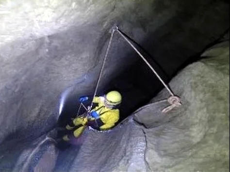
Rowten Pot — cave in the parish of Thorton-in-Craven, North Yorkshire, UK.

Wikimedia Commons contributors — see linked file page for photographer and licence licence
Plan your visit
- Typical visit
- 3 h–8 h
- Best time of year
- Late spring – early autumn (May–Oct)
- Nearest railway station
- Ribblehead · 6.8 km
- Free entry
- Dog-friendly
About
Rowten Pot is a named summit in the United Kingdom. Wikidata describes it as: "cave in the parish of Thorton-in-Craven, North Yorkshire, UK". Coordinates: 54.1969°, -2.4641°.
Photo gallery
Protected designations
- Site of Special Scientific Interest: Whernside SSSI
Designations sourced from Natural England open data under OGL v3.
From the Wikipedia article
Rowten Pot is one of several entrances into the 27-kilometre (17 mi) long cave system that drains Kingsdale in North Yorkshire, England. Its entrance is a shaft some 27 metres (89 ft) long, 10 metres (33 ft) wide, and at the southern end 72 metres (236 ft) deep.
Excerpt from Wikipedia under CC BY-SA 4.0. See the source article linked in Sources below.
Background
History
The first description of Rowten Pot appeared in verse in Thomas Dixon's A Description of the Environs of Ingleborough of 1781:<blockquote>The Routing-Chasm amazing to behold,<br />With dreadful yawn intimidates the bold:<br />The depth unknown, vast, dismal, dark and wide,<br />With rugged pointed rocks on every side;<br />A rapid stream falls in with hideous roar,<br />Growls thro the mountain to some distant shore:<br />Dismay arrests the man that ventures near,<br />His face turns pale, his courage yields to fear.</blockquote> In a guide book published in 1865, there is an account of a Mr. Hunter claiming to have made a complete descent, but the account is exaggerated and bears little…
Description
A stream enters from just below the surface at the northern end. The cave is largely vertical, but at the bottom the stream flows through a short section of passage into the underground West Kingsdale river. This connects downstream with the Kingsdale Master Cave through three short sumps. The cave is usually descended using single rope techniques, and is popular with cavers, being spacious and offering a variety of aerial routes. The three short sumps which connect to the Kingsdale Master Cave can be free-dived. The water which descends Rowten Pot sinks 150 m to the west of the pot on the other side of Turbary Road, into a shallow horizontal cave system, known as Rowten Caves. This can be…
Sourced from Wikipedia under CC BY-SA 4.0.
- Coordinates
- 54.1969, -2.4641
- Address
- Kingsdale, North Yorkshire, UK
- Nearest railway station
- Ribblehead — 6.8 km
Sources
- wikidata: Q7372295 (CC0)
- wikipedia: Rowten Pot (CC BY-SA 4.0)
- commons: Rowton Pot entrance.jpg (CC BY-SA 4.0)
Other places nearby
Loading nearby places…
Nearby
 📷 3
📷 3Caves · North West England
Rowten Pot
Rowten Pot is a cave in the United Kingdom.
 📷 3
📷 3Caves · North West England
Rowten Cave
Rowten Cave is a cave in the United Kingdom.
 📷 3
📷 3Caves · North West England
Simpson Pot
Simpson Pot is a cave in the United Kingdom.
 📷 3
📷 3Mountains & hills · North West England
Simpson Pot
Simpson Pot — cave in North Yorkshire, England.
 📷 3
📷 3Caves · North West England
Aquamole Pot
Aquamole Pot is a cave in the United Kingdom.
 📷 3
📷 3Caves · North West England
Jingling Pot
Jingling Pot is a cave in the United Kingdom.
More mountains in this region
 📷 3
📷 3Mountains & hills · North West England
Allen Crags
Allen Crags — Named summit at 785 m.
 📷 3
📷 3Mountains & hills · North West England
Alum Pot
Alum Pot — Open shaft pothole in North Yorkshire.
 📷 3
📷 3Mountains & hills · North West England
Arnside Knott
Arnside Knott — Named summit at 159 m.
 📷 3
📷 3Mountains & hills · North West England
Aye Gill Pike
Aye Gill Pike — Named summit at 556.3 m.
Frequently asked questions
- Where is Rowten Pot?
- Rowten Pot is in North-West England, United Kingdom.
- Is Rowten Pot a protected site?
- Yes — Rowten Pot is part of the Whernside SSSI Site of Special Scientific Interest.
- Is Rowten Pot free to visit?
- Yes, Rowten Pot is free to enter.
- How do I get to Rowten Pot?
- The nearest railway station is Ribblehead, about 6.8 km away.