Reservoirs & lochs · West Midlands
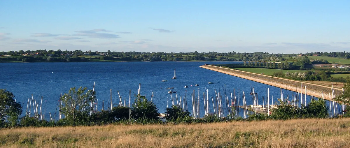
Netherton Reservoir
Netherton Reservoir — reservoir in West Midlands, England, UK.

Wikimedia Commons contributors — see linked file page for photographer and licence licence
Plan your visit
- Typical visit
- 1 h–2.5 h
- Nearest railway station
- Cradley Heath · 1.7 km
- Free entry
- Dog-friendly
About
Netherton Reservoir is a reservoir in the United Kingdom. It covers approximately 4 km². Wikidata describes it as: "reservoir in West Midlands, England, UK". Coordinates: 52.4846°, -2.0942°.
Photo gallery
Protected designations
- Site of Special Scientific Interest: Brewin's Canal Section SSSI
- National Nature Reserve: SALTWELLS
Designations sourced from Natural England open data under OGL v3.
From the Wikipedia article
Netherton Reservoir - otherwise known as Lodge Farm Reservoir or locally known as The Rezza is a canal feeder reservoir in the Netherton district of Dudley, England. It opened in 1838, and is now used for watersports, as well as supplying water to the canal system. The Dudley Canal Line No 2 followed a circuitous route, but in the 1830s Thomas Brewin was responsible for building a more direct route. The total length of the new canal, which opened in 1838, was about 400 yards (370 m), which included a 75-yard (69 m) tunnel, known as Brewin's Tunnel. The new route enabled a reservoir to be built over the old course of the canal, together with a steam-powered pumping engine. The tunnel did not last long, as it was opened out in 1858, necessitating the construction of a bridge to carry the lane which had previously crossed over the top of the tunnel. The bridge is now called High Bridge (locally known as the "Sounding Bridge"), and the lane is called Highbridge Road. The reservoir, which was built between 1835 and 1838, acted as a storage reservoir, so that when water was plentiful, as a result of rain, it could be pumped from the canal into the reservoir, and then released back into the canal through sluices near the tunnel when it was required. The engine was installed in 1840, and drove a scoop wheel. A cottage was provided for the sluice keeper. With the nationalisation of the canals in 1948, ownership of the reservoir passed from the Birmingham Canal Navigations, with whom the Dudley Canal had amalgamated in 1846, to British Waterways. They sold it to Dudley Metropolitan Borough Council in 1966, who wanted to improve the leisure facilities within their area, and have since developed it for watersports, although it still supplies water to the canal.
Excerpt from Wikipedia under CC BY-SA 4.0. See the source article linked in Sources below.
- Coordinates
- 52.4846, -2.0942
- District
- Dudley
- Parish
- Dudley, unparished area
- Postcode
- DY2 0HB
- Parliamentary constituency
- Halesowen
- Nearest railway station
- Cradley Heath — 1.7 km
Sources
- wikidata: Q6999676 (CC0)
- wikipedia: Netherton Reservoir (CC BY-SA 4.0)
- commons: Lodge Farm Reservoir.JPG (CC BY-SA 4.0)
Other places nearby
Loading nearby places…
Nearby
 📷 3
📷 3Forests & woodlands · West Midlands
Saltwells National Nature Reserve Black Country Geosite
Saltwells National Nature Reserve Black Country Geosite is a forest or woodland in the United Kingdom.
📷 3Parks · West Midlands
Saltwells Local Nature Reserve
Saltwells Local Nature Reserve — park in United Kingdom.
 📷 3
📷 3Forests & woodlands · West Midlands
Doulton's Claypit SSSI
Doulton's Claypit SSSI is a forest or woodland in the United Kingdom.
 📷 3
📷 3Historic bridges · West Midlands
Towpath Bridge, Approximately 300 Metres North West Of Highbridge Road
Towpath Bridge, Approximately 300 Metres North West Of Highbridge Road — Grade II listed building-listed bridge in england-west-midlands, United Kingdom.
 📷 3
📷 3Historic bridges · West Midlands
Dudley Number 1 Canal Towpath Bridge, Approximately 50 Metres East Of Woodside Bridge
Dudley Number 1 Canal Towpath Bridge, Approximately 50 Metres East Of Woodside Bridge — Grade II listed building-listed bridge in england-west-midlands, United Kingdom.
 📷 5
📷 5Natural landmarks · West Midlands
Hillcrest School, Birmingham
Hillcrest School, Birmingham — a school heritage in england-west-midlands, United Kingdom.
More places in this region
 Flagship📷 3
Reservoirs & lochs · West Midlands
Draycote Water
Draycote Water — reservoir in the United Kingdom.
 📷 3
📷 3Reservoirs & lochs · West Midlands
Abingdon Reservoir
Abingdon Reservoir — proposed reservoir in Oxfordshire, England, UK.
 📷 3
📷 3Reservoirs & lochs · West Midlands
Aston Reservoir
Aston Reservoir — reservoir in Birmingham, West Midlands, England, UK.
 📷 3
📷 3Reservoirs & lochs · West Midlands
Babbs Mill Lake
Babbs Mill Lake — reservoir in West Midlands, England, UK.
Frequently asked questions
- Where is Netherton Reservoir?
- Netherton Reservoir is in the West Midlands, United Kingdom (postcode DY2 0HB), in the parish of Dudley, unparished area.
- Is Netherton Reservoir a protected site?
- Yes — Netherton Reservoir is part of the Brewin's Canal Section SSSI Site of Special Scientific Interest and the SALTWELLS National Nature Reserve.
- How do I get to Netherton Reservoir?
- The nearest railway station is Cradley Heath, about 1.7 km away. Drivers can navigate to postcode DY2 0HB.