Mountains & hills · North Wales
Moel Llyfnant
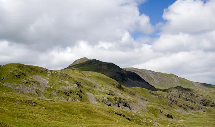
Moel Llyfnant — Named summit at 751 m.

Wikimedia Commons contributors — see linked file page for photographer and licence licence
Plan your visit
- Typical visit
- 3 h–8 h
- Best time of year
- Late spring – early autumn (May–Oct)
- Nearest railway station
- Llanuwchllyn · 8.9 km
- Free entry
- Dog-friendly
About
Moel Llyfnant is a named summit in the United Kingdom. Wikidata describes it as: "Named summit at 751 m.". Coordinates: 52.9009°, -3.7732°.
Photo gallery
From the Wikipedia article
Moel Llyfnant is a mountain in the southern portion of the Snowdonia National Park in Gwynedd, Wales. It is a peak in the Arenig mountain range. It lies to the west of Arenig Fawr. It has one notable top, the twin peaked Gallt y Daren, being at the end of its west ridge. The summit area has rocky outcrops, on top of one lies the small cairn that marks the summit. The views of Arenig Fawr are excellent, while to the south Rhobell Fawr and Dduallt can be observed, and to the west Gallt y Daren and Foel Boeth.
Excerpt from Wikipedia under CC BY-SA 4.0. See the source article linked in Sources below.
- Coordinates
- 52.9009, -3.7732
- Address
- Gwynedd, Wales
- Nearest railway station
- Llanuwchllyn — 8.9 km
Sources
- osm: n29762083 (ODbL)
- wikipedia: Moel Llyfnant (CC BY-SA 4.0)
- commons: Moel Llyfnant - geograph.org.uk - 143518.jpg (CC BY-SA 4.0)
Other places nearby
Loading nearby places…
Nearby
 📷 3
📷 3Archaeological sites · North Wales
Moel Llyfnant Manganese Mine
Moel Llyfnant Manganese Mine — a archaeological in wales-north, United Kingdom.
 📷 2
📷 2Mountains & hills · North Wales
Foel Ystrodur Fawr
Foel Ystrodur Fawr — a mountain in wales-north, United Kingdom, 518 m.
 📷 3
📷 3Mountains & hills · North Wales
Arenig Fawr South Ridge Top
Arenig Fawr South Ridge Top — Named summit at 712 m.
 📷 3
📷 3Mountains & hills · North Wales
Arenig Fawr South Top
Arenig Fawr South Top — Named summit at 836 m.
 📷 3
📷 3Historic houses · North Wales
Amnodd-wen
Amnodd-wen — a historic house in wales-north, United Kingdom.
 📷 3
📷 3Mountains & hills · North Wales
Carreg y Diocyn
Carreg y Diocyn — a mountain in wales-north, United Kingdom, 673 m.
More mountains in this region
 📷 5
📷 5Mountains & hills · North Wales
Cemlyn Bay and lagoon
Cemlyn Bay and lagoon — Site of Special Scientific Interest in Wales.
 📷 3
📷 3Mountains & hills · North Wales
Aberffraw Bay
Aberffraw Bay — bay on the west coast of Anglesey, in Wales, UK.
 📷 3
📷 3Mountains & hills · North Wales
Allt-fawr
Allt-fawr — Named summit at 698 m.
 📷 3
📷 3Mountains & hills · North Wales
Aran Benllyn
Aran Benllyn — Named summit at 884 m.
Frequently asked questions
- Where is Moel Llyfnant?
- Moel Llyfnant is in North Wales, in the United Kingdom — coordinates 52.9009°, -3.7732°. The nearest railway station is Llanuwchllyn, around 8.9 km away.
- Is Moel Llyfnant free to visit?
- Yes — admission to Moel Llyfnant is free.