Mountains & hills · North Wales
Allt-fawr
Also known as: Yr Allt Fawr;Allt Fawr, Allt Fawr
Allt-fawr — Named summit at 698 m.

Wikimedia Commons contributors — see linked file page for photographer and licence licence
Plan your visit
- Typical visit
- 3 h–8 h
- Best time of year
- Late spring – early autumn (May–Oct)
- Nearest railway station
- Blaenau Ffestiniog · 2.4 km
- Free entry
- Dog-friendly
About
Allt-fawr is a named summit in the United Kingdom. Also known as: Yr Allt Fawr;Allt Fawr. Wikidata describes it as: "Named summit at 698 m.". Coordinates: 53.0082°, -3.9663°.
Photo gallery
From the Wikipedia article
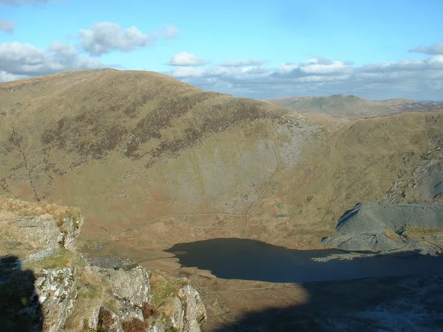
Allt-fawr is a mountain in Snowdonia, North Wales and forms part of the Moelwynion group. It is on the internal border of Snowdonia National Park, and overlooks the town of Blaenau Ffestiniog, with its numerous slate quarries, as well as Llyn Ystradau and Ffestiniog Power Station in Tanygrisiau. On the northern slope of Allt-fawr is the Oakeley Quarry, the world's largest underground slate mine. On the southern slope is the large Cwmorthin Quarry. These two mines are joined underneath the summit of Allt-fawr and the extensive chambering and adits are visible on the surface of the mountain where underground workings have collapsed. Between 1974 and 1997, the Gloddfa Ganol tourist attraction operated within the Oakeley Quarry on the south slope of the mountain.
Excerpt from Wikipedia under CC BY-SA 4.0. See the source article linked in Sources below.
- Coordinates
- 53.0082, -3.9663
- District
- Gwynedd
- Parish
- Ffestiniog
- Postcode
- LL41 3ND
- Parliamentary constituency
- Dwyfor Meirionnydd
- Nearest railway station
- Blaenau Ffestiniog — 2.4 km
Sources
- osm: n3300193289 (ODbL)
- wikipedia: Allt-fawr (CC BY-SA 4.0)
- commons: Llyn Cwmorthin 341563.jpg (CC BY-SA 4.0)
Other places nearby
Loading nearby places…
Nearby
 📷 3
📷 3Natural landmarks · North Wales
Allt-fawr
Allt-fawr — mountain (698m) in Gwynedd, Wales.
 📷 3
📷 3Mountains & hills · North Wales
Mynydd Iwerddon
Mynydd Iwerddon — a mountain in wales-north, United Kingdom, 583 m.
 📷 3
📷 3Mountains & hills · North Wales
Moel Druman
Moel Druman — Named summit at 676 m.
 📷 3
📷 3Natural landmarks · North Wales
Moel Druman
Moel Druman — mountain (676m) in Gwynedd.
 📷 3
📷 3Mountains & hills · North Wales
Craig Nyth-y-Gigfran
Craig Nyth-y-Gigfran — a mountain in wales-north, United Kingdom, 554 m.
 📷 3
📷 3Mountains & hills · North Wales
Ysgafell Wen
Ysgafell Wen — Named summit at 672 m.
More mountains in this region
 📷 5
📷 5Mountains & hills · North Wales
Cemlyn Bay and lagoon
Cemlyn Bay and lagoon — Site of Special Scientific Interest in Wales.
 📷 3
📷 3Mountains & hills · North Wales
Aberffraw Bay
Aberffraw Bay — bay on the west coast of Anglesey, in Wales, UK.
 📷 3
📷 3Mountains & hills · North Wales
Aran Benllyn
Aran Benllyn — Named summit at 884 m.
 📷 3
📷 3Mountains & hills · North Wales
Aran Fawddwy
Aran Fawddwy — Named summit at 905 m.
Frequently asked questions
- Where is Allt-fawr?
- Allt-fawr is in North Wales, United Kingdom (postcode LL41 3ND), in the parish of Ffestiniog.
- Is Allt-fawr free to visit?
- Yes, Allt-fawr is free to enter.
- How do I get to Allt-fawr?
- The nearest railway station is Blaenau Ffestiniog, about 2.4 km away. Drivers can navigate to postcode LL41 3ND.