Mountains & hills · North Wales
Arenig Fawr South Ridge Top
Also known as: Arenig Fawr Copa'r Grib Ddeheuol
Arenig Fawr South Ridge Top — Named summit at 712 m.

Wikimedia Commons contributors — see linked file page for photographer and licence licence
Plan your visit
- Typical visit
- 3 h–8 h
- Best time of year
- Late spring – early autumn (May–Oct)
- Nearest railway station
- Llanuwchllyn · 7.9 km
- Free entry
- Dog-friendly
About
Arenig Fawr South Ridge Top is a named summit in the United Kingdom. Also known as: Arenig Fawr Copa'r Grib Ddeheuol. Wikidata describes it as: "Named summit at 712 m.". Coordinates: 52.9081°, -3.7450°.
Photo gallery
From the Wikipedia article
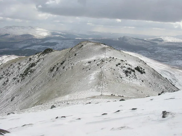
Arenig Fawr South Ridge Top is a top of Arenig Fawr in southern Snowdonia, North Wales. It lies in area of rocky knolls and small tarns, found on the broad south ridge of Arenig Fawr. The summit, marked by a few stones, is a top of the highest rocky outcrop found in the area. The views are limited, blocked by the bulk of Arenig Fawr. A path leads down the west flank of the ridge towards Moel Llyfnant.
Excerpt from Wikipedia under CC BY-SA 4.0. See the source article linked in Sources below.
- Coordinates
- 52.9081, -3.7450
- Address
- Gwynedd, Wales
- Nearest railway station
- Llanuwchllyn — 7.9 km
Sources
- osm: n7706820577 (ODbL)
- wikipedia: Arenig Fawr South Ridge Top (CC BY-SA 4.0)
- commons: Arenig Fawr south.jpg (CC BY-SA 4.0)
Other places nearby
Loading nearby places…
Nearby
 📷 3
📷 3Mountains & hills · North Wales
Carreg y Diocyn
Carreg y Diocyn — a mountain in wales-north, United Kingdom, 673 m.
 📷 3
📷 3Mountains & hills · North Wales
Arenig Fawr South Top
Arenig Fawr South Top — Named summit at 836 m.
 📷 3
📷 3Mountains & hills · North Wales
Arenig Fawr
Arenig Fawr — Named summit at 854 m.
 📷 3
📷 3Memorials & monuments · North Wales
Flying Fortress Crash August 1943
Flying Fortress Crash August 1943 — a memorial in wales-north, United Kingdom.
 📷 3
📷 3Natural landmarks · North Wales
Arenig Fawr
Arenig Fawr — mountain (854m) in Gwynedd, Wales.
 📷 3
📷 3Mountains & hills · North Wales
Moel Llechwedd
Moel Llechwedd — a mountain in wales-north, United Kingdom, 817 m.
More mountains in this region
 📷 5
📷 5Mountains & hills · North Wales
Cemlyn Bay and lagoon
Cemlyn Bay and lagoon — Site of Special Scientific Interest in Wales.
 📷 3
📷 3Mountains & hills · North Wales
Aberffraw Bay
Aberffraw Bay — bay on the west coast of Anglesey, in Wales, UK.
 📷 3
📷 3Mountains & hills · North Wales
Allt-fawr
Allt-fawr — Named summit at 698 m.
 📷 3
📷 3Mountains & hills · North Wales
Aran Benllyn
Aran Benllyn — Named summit at 884 m.
Frequently asked questions
- Where is Arenig Fawr South Ridge Top?
- Arenig Fawr South Ridge Top is in North Wales, United Kingdom.
- Is Arenig Fawr South Ridge Top free to visit?
- Yes, Arenig Fawr South Ridge Top is free to enter.
- How do I get to Arenig Fawr South Ridge Top?
- The nearest railway station is Llanuwchllyn, about 7.9 km away.