Towns & cities · London
Ellington
Also known as: Ellington, Swydd Gaergrawnt
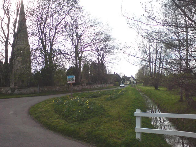
Ellington — village and civil parish in Cambridgeshire, UK.

Wikimedia Commons contributors — see linked file page for photographer and licence licence
Plan your visit
- Typical visit
- 3 h–6 h
- Nearest railway station
- Huntingdon · 7.3 km
- Free entry
- Family-friendly
- Dog-friendly
About
Ellington is a town, city, village or settlement in the United Kingdom. Recent population estimates put it at around 217 people. Address: PE28. Wikidata describes it as: "village and civil parish in Cambridgeshire, UK". Coordinates: 52.3300°, -0.3000°.
Photo gallery
From the Wikipedia article
Ellington is a village and civil parish in Cambridgeshire, England, 4 miles (6 km) west of Huntingdon in Huntingdonshire, a non-metropolitan district of Cambridgeshire and historic county of England. The civil parish covers an area of 2,700 acres (1,100 hectares); much of it is grassland with some small woods in the south of the parish. The village had 235 households and a population of 585 at the 2011 census. The civil parish also includes Ellington Thorpe, a smaller settlement 1 mile (1.6 km) south of Ellington with a few 17th-century cottages, previously known as Sibthorpe.
Excerpt from Wikipedia under CC BY-SA 4.0. See the source article linked in Sources below.
Background
History
In 1085, William the Conqueror ordered that a survey should be carried out across his kingdom to discover who owned which parts and what it was worth. The survey took place in 1086 and the results were recorded in what, since the 12th century, has become known as the Domesday Book. Starting with the king himself, for each landholder within a county there is a list of their estates or manors; and, for each manor, there is a summary of the resources of the manor, the amount of annual rent that was collected by the lord of the manor both in 1066 and in 1086, together with the taxable value. Ellington was listed in the Domesday Book in the Hundred of Leightonstone in Huntingdonshire; the name…
Sourced from Wikipedia under CC BY-SA 4.0.
- Coordinates
- 52.3300, -0.3000
- County
- Cambridgeshire
- District
- Huntingdonshire
- Parish
- Ellington
- Postcode
- PE28
- Parliamentary constituency
- Huntingdon
- Population
- 217
- Nearest railway station
- Huntingdon — 7.3 km
Sources
- wikidata: Q1831341 (CC0)
- wikipedia: Ellington, Cambridgeshire (CC BY-SA 4.0)
- commons: All Saints Church, Ellington - geograph.org.uk - 21364.jpg (CC BY-SA 4.0)
Other places nearby
Loading nearby places…
Nearby
 📷 5
📷 5Memorials & monuments · London
Ellington War Memorial
Ellington War Memorial — Grade II listed building-listed memorial in england-london, United Kingdom.
 📷 5
📷 5Historic churches · London
Parish Church of St Peter
Parish Church of St Peter — church in Easton, Cambridgeshire, England, UK.
Caravan parks · London
Grafham Water Caravan and Motorhome Club
Grafham Water Caravan and Motorhome Club — a caravan park in england london.
 📷 5
📷 5Forests & woodlands · London
Brampton Wood
Brampton Wood is a forest or woodland in the United Kingdom.
 📷 5
📷 5Public art & sculpture · London
Grafham
Grafham — a public art in england-london, United Kingdom.
 📷 5
📷 5Wildlife reserves · London
Brampton Wood
Brampton Wood — nature reserve in Cambridgeshire, England, UK.
More towns in this region
 Flagship📷 10
Towns & cities · London
Aldenham
Aldenham — village and civil parish in Hertfordshire, England.
 Flagship📷 10
Towns & cities · London
Ashdon
Ashdon — village and civil parish in Essex, UK.
 Flagship📷 10
Towns & cities · London
Betchworth
Betchworth — village and civil parish in the Mole Valley district of Surrey, England.
 Flagship📷 10
Towns & cities · London
Boxley
Boxley — village and civil parish in Maidstone District, Kent, England, UK.
Frequently asked questions
- Where is Ellington?
- Ellington is in Cambridgeshire, London, United Kingdom (postcode PE28), in the parish of Ellington.
- Is Ellington free to visit?
- Yes, Ellington is free to enter.
- How do I get to Ellington?
- The nearest railway station is Huntingdon, about 7.3 km away. Drivers can navigate to postcode PE28.