Natural landmarks · Northern Ireland
Boho
Also known as: Botha
Boho in Northern Ireland, United Kingdom.

Dean Molyneaux — CC BY-SA 2.0 via Wikimedia Commons licence
Plan your visit
- Typical visit
- 1 h–2 h
- Free entry
- Dog-friendly
About
Boho is a place of interest in Northern Ireland, United Kingdom — drawn from open-data sources for visitor reference. See the linked Wikipedia article for the full description.
Photo gallery
From the Wikipedia article
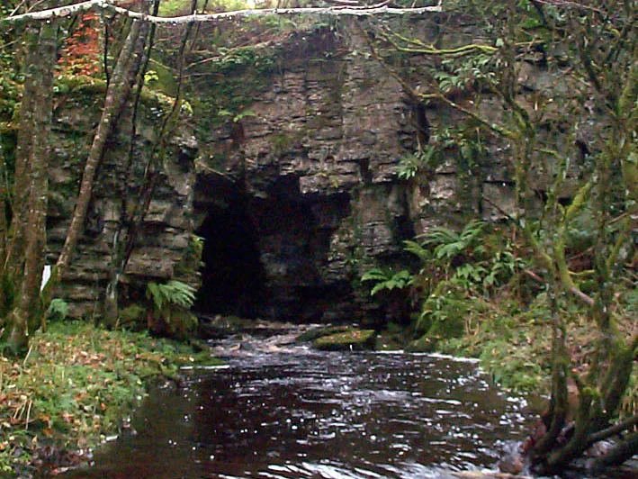
Boho (pronounced BOH, from Irish Botha, meaning 'huts') is a hamlet and a civil parish 11 kilometres (7 mi) covering approximately 12 km × 7 km (7 mi × 4 mi) southwest of Enniskillen in County Fermanagh, Northern Ireland. It is situated within Fermanagh and Omagh district. This area contains a high density of historically significant sites stretching from the Neolithic Reyfad Stones, through the Bronze Age/Iron Age (Aghnaglack Tomb) and medieval (High Crosses) to comparatively recent historical buildings such as the Linnett Inn. Boho parish has a high biodiversity of flora and fauna due in part to the niches offered by the limestone karst substrata combined with fen meadow, upland heath and acidic bog. The three mountains found within the parish; namely Glenkeel, Knockmore and Belmore provide a landscape varying from high craggy bluffs, with views of neighbouring counties, to low, flat bogland punctuated by streams and lakes. Below this landscape are two of the three most cave-rich mountains in Northern Ireland, featuring the deepest cave system in Ireland at Reyfad Pot, the deepest daylight shaft in Ireland at Noon's Hole, as well as popular caves for local outdoor adventure centre groups at the Boho Caves and the nearby Pollnagollum Coolarkan.
Excerpt from Wikipedia under CC BY-SA 4.0. See the source article linked in Sources below.
Background
Description
The Linnet Inn, situated near Boho Cross-Roads (glack cross) is over 200 years old and is one of the few remaining thatched public houses in Ireland. It contains a classic style open hearth fire and a unique "cave bar" in homage to the local caves designed and constructed by its previous owner, Brian McKenzie.
Sourced from Wikipedia under CC BY-SA 4.0.
- Coordinates
- 54.3497, -7.7957
- District
- Fermanagh and Omagh
- Postcode
- BT74 5AG
- Parliamentary constituency
- Fermanagh and South Tyrone
Sources
- wikidata: Q3929375 (CC0)
- wikipedia: Boho, County Fermanagh (CC BY-SA 4.0)
Other places nearby
Loading nearby places…
Nearby
📷 3Natural landmarks · Northern Ireland
Knocknahunshin
Knocknahunshin in Northern Ireland, United Kingdom.
 📷 3
📷 3Mountains & hills · Northern Ireland
Boho Caves
Boho Caves — cave in United Kingdom.
 📷 2
📷 2Natural landmarks · Northern Ireland
Aghaherrish
Aghaherrish in Northern Ireland, United Kingdom.
📷 3Natural landmarks · Northern Ireland
Drummacoorin
Drummacoorin in Northern Ireland, United Kingdom.
 📷 3
📷 3Natural landmarks · Northern Ireland
Carn
Carn in Northern Ireland, United Kingdom.
 📷 2
📷 2Natural landmarks · Northern Ireland
Kilnamaddoo
Kilnamaddoo in Northern Ireland, United Kingdom.
More natural landmarks in this region
 Flagship📷 4
Natural landmarks · Northern Ireland
Lough Erne
Lough Erne — lake in County Fermanagh, Northern Ireland, UK.
 Flagship📷 4
Natural landmarks · Northern Ireland
Lough Neagh
Lough Neagh — large lake in Northern Ireland.
 📷 3
📷 3Natural landmarks · Northern Ireland
Ballysaggart Lough
Ballysaggart Lough — lake in the United Kingdom.
 📷 5
📷 5Natural landmarks · Northern Ireland
Belmore Mountain
Belmore Mountain — mountain in the United Kingdom.
Frequently asked questions
- Where is Boho?
- Boho is in Northern Ireland, United Kingdom (postcode BT74 5AG).
- Is Boho free to visit?
- Yes, Boho is free to enter.
- How do I get to Boho?
- Drivers can navigate to postcode BT74 5AG. It sits within the Fermanagh and South Tyrone parliamentary constituency.