Mountains & hills · Scottish Highlands
Beinn Ghlas
Beinn Ghlas — Named summit at 1103 m.

Wikimedia Commons contributors — see linked file page for photographer and licence licence
Plan your visit
- Typical visit
- 3 h–8 h
- Best time of year
- Late spring – early autumn (May–Oct)
- Free entry
- Dog-friendly
About
Beinn Ghlas is a named summit in the United Kingdom. Wikidata describes it as: "Named summit at 1103 m.". Coordinates: 56.5360°, -4.2370°.
Photo gallery
From the Wikipedia article
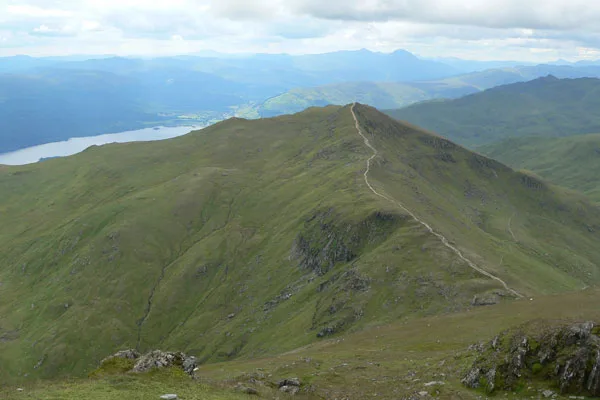
Beinn Ghlas is a mountain in the Breadalbane region of the Scottish Highlands. It lies on the north shore of Loch Tay and is part of the Ben Lawers Range. It is a Munro with a height of 1,103 metres (3,619 ft). The Gaelic name is translated as 'grey-green mountain', which refers to the colour of the mica-schist that makes up the bulk of the mountain and that falls as a scree on its south-western side. The path up the mountain leads past outcrops of this rock that also reveal large garnets. The usual route to the summit leaves from the car park, follows Edramucky Burn, and climbs to the south-western ridge of the mountain. The deep corrie of Coire Odhar (the dun-coloured corrie) lies to the north. Walkers who continue on to Ben Lawers can avoid the 100-metre re-ascent of Beinn Ghlas on their return by taking the path that runs west of the summit, down to Coire Odhar.
Excerpt from Wikipedia under CC BY-SA 4.0. See the source article linked in Sources below.
- Coordinates
- 56.5360, -4.2370
- Address
- Perth and Kinross, Scotland
- Official site
- www.walkhighlands.co.uk
Sources
- osm: n56114463 (ODbL)
- wikipedia: Beinn Ghlas (CC BY-SA 4.0)
- commons: Beinn ghlas.jpg (CC BY-SA 4.0)
Other places nearby
Loading nearby places…
Nearby
 📷 3
📷 3Natural landmarks · Scottish Highlands
Beinn Ghlas
Beinn Ghlas — 1103m high mountain in Perth and Kinross, Scotland, UK.
 📷 3
📷 3Mountains & hills · Scottish Highlands
Meall Corranaich
Meall Corranaich — Named summit at 1069 m.
 📷 5
📷 5Mountains & hills · Scottish Highlands
Ben Lawers
Ben Lawers — Named summit at 1214 m.
 📷 5
📷 5Natural landmarks · Scottish Highlands
Ben Lawers
Ben Lawers — 1214m high mountain in Perth and Kinross, Scotland, UK.
 📷 3
📷 3Mountains & hills · Scottish Highlands
Sron Dha Mhurchaidh
Sron Dha Mhurchaidh — a mountain in scotland-highlands, United Kingdom.
 📷 3
📷 3Mountains & hills · Scottish Highlands
Ben Lawers - Creag an Fhithich
Ben Lawers - Creag an Fhithich — a mountain in scotland-highlands, United Kingdom.
More mountains in this region
 📷 3
📷 3Mountains & hills · Scottish Highlands
A' Bhuidheanach Bheag
A' Bhuidheanach Bheag — Named summit at 936 m.
 📷 3
📷 3Mountains & hills · Scottish Highlands
A' Chailleach
A' Chailleach — Named summit at 997 m.
 📷 3
📷 3Mountains & hills · Scottish Highlands
A' Chailleach
A' Chailleach — Named summit at 930 m.
 📷 3
📷 3Mountains & hills · Scottish Highlands
A' Chaoirnich
A' Chaoirnich — Named summit at 875 m.
Frequently asked questions
- Where is Beinn Ghlas?
- Beinn Ghlas is in Scottish Highlands, in the United Kingdom — coordinates 56.5360°, -4.2370°.
- Is Beinn Ghlas free to visit?
- Yes — admission to Beinn Ghlas is free.