Harbours & ports · South Wales
Avonmouth
Avonmouth — port, suburb and former electoral ward in Bristol, England.

Wikimedia Commons contributors — see linked file page for photographer and licence licence
Plan your visit
- Typical visit
- 45 min–1.5 h
- Nearest railway station
- Avonmouth · 0.1 km
- Family-friendly
- Dog-friendly
About
Avonmouth is a harbour in the United Kingdom. Recent population estimates put it at around 3,402 people. Address: BS11. Wikidata describes it as: "port, suburb and former electoral ward in Bristol, England". Coordinates: 51.5010°, -2.6990°.
Photo gallery
Protected designations
- Site of Special Scientific Interest: Severn Estuary SSSI
- Ramsar wetland: Severn Estuary
Designations sourced from Natural England open data under OGL v3.
From the Wikipedia article
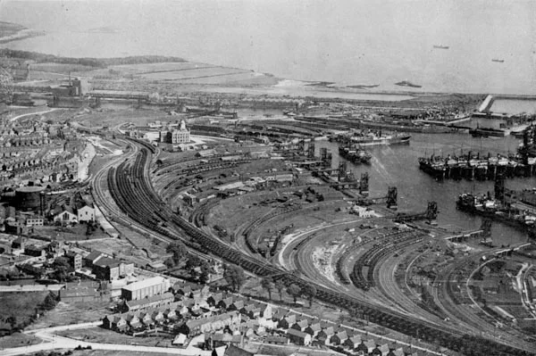
Avonmouth ( AY-vən-mowth) is a port and outer suburb of Bristol, England, on the north bank of the mouth of the River Avon and the eastern shore of the Severn Estuary. Part of the Port of Bristol, Avonmouth Docks is important to the region's maritime economy, hosting large vessels for the unloading and exporting of heavier goods. Much of the land use is industrial, including warehousing, light industry, electrical power and sanitation. The M5 motorway bisects the neighbourhood, with junctions onto the A4 road and M49 motorway, and it has stations on the Severn Beach Line railway. Avonmouth is part of the Bristol City Council electoral ward of Avonmouth and Lawrence Weston, which also includes Shirehampton and the western end of Lawrence Weston.
Excerpt from Wikipedia under CC BY-SA 4.0. See the source article linked in Sources below.
Background
History
The area was historically part of the chapelry of Shirehampton, a detached part of the ancient parish of Westbury-on-Trym in Gloucestershire. Bewys Cross, a stone monument possibly dating from the 15th century, was located on the bank of the Severn close to the old mouth of the Avon. As depicted on James Millerd's 1673 map of Bristol, the main elements of the Avonmouth area in the medieval and early modern period were the Kingroad (the bay between the Avonmouth and Portishead) and the Hungroad (the anchorage in the lower Avon between Shirehampton and Pill. Both are depicted on Greenvile Collins c.1693 chart of the Bristol Channel, which includes a detail image that depicts King William…
Description
Avonmouth is home to the largest single footprint warehouse in the United Kingdom, a 1,250,000 sq ft portal frame building operated by The Range as a distribution centre. The enormous building occupies 55 acres of land and is part of the Central Park project located close to the Severn estuary shoreline. Previously, the largest single footprint warehouse in the United Kingdom was a building operated by Amazon in Dunfermline, Scotland which covers 1,000,000 sq ft.
Sourced from Wikipedia under CC BY-SA 4.0.
- Coordinates
- 51.5010, -2.6990
- District
- Bristol, City of
- Parish
- Bristol, City of, unparished area
- Postcode
- BS11
- Parliamentary constituency
- Bristol North West
- Population
- 3,402
- Nearest railway station
- Avonmouth — 0.1 km
- Official site
- www.avonmouthcca.org.uk
Sources
- wikidata: Q1792885 (CC0)
- wikipedia: Avonmouth (CC BY-SA 4.0)
- commons: Avonmouth St Andrew.JPG (CC BY-SA 4.0)
Other places nearby
Loading nearby places…
Nearby
 📷 5
📷 5Harbours & ports · South Wales
Port of Bristol
Port of Bristol is a harbour in the United Kingdom.
 📷 3
📷 3Historic bridges · South Wales
Avonmouth Bridge
Avonmouth Bridge is a historic bridge in the United Kingdom.
 📷 3
📷 3Memorials & monuments · South Wales
Avonmouth Bridge Workers Memorial
Avonmouth Bridge Workers Memorial — a memorial in wales-south, United Kingdom.
.jpg?width=1200) 📷 3
📷 3Forests & woodlands · South Wales
Lamplighter's Marsh Nature Reserve
Lamplighter's Marsh Nature Reserve is a forest or woodland in the United Kingdom.
 📷 3
📷 3Memorials & monuments · South Wales
Penpole Point
Penpole Point is a memorial in the United Kingdom.
 📷 3
📷 3Museums · South Wales
Blaise Museum - Kingsweston Roman Villa
Blaise Museum - Kingsweston Roman Villa — a museum in wales-south, United Kingdom.
More places in this region
 Flagship📷 5
Harbours & ports · South Wales
Barry Docks
Barry Docks is a harbour in the United Kingdom.
 📷 3
📷 3Harbours & ports · South Wales
Barry Harbour
Barry Harbour — former harbour in Barry, Vale of Glamorgan.
 📷 5
📷 5Harbours & ports · South Wales
Bristol Harbour
Bristol Harbour — harbour in the city of Bristol, England.
 📷 3
📷 3Harbours & ports · South Wales
Burry Port Harbour
Burry Port Harbour — industrial port for coal industry.
Frequently asked questions
- Where is Avonmouth?
- Avonmouth is in South Wales, United Kingdom (postcode BS11), in the parish of Bristol, City of, unparished area.
- Is Avonmouth a protected site?
- Yes — Avonmouth is part of the Severn Estuary SSSI Site of Special Scientific Interest and the Severn Estuary Ramsar wetland.
- How do I get to Avonmouth?
- The nearest railway station is Avonmouth, about 0.1 km away. Drivers can navigate to postcode BS11.