Harbours & ports · South Wales
Port of Bristol
Port of Bristol is a harbour in the United Kingdom.

Wikimedia Commons contributors — see linked file page for photographer and licence licence
Plan your visit
- Typical visit
- 45 min–1.5 h
- Nearest railway station
- Avonmouth · 1.3 km
- Family-friendly
- Dog-friendly
About
Port of Bristol is a harbour in the United Kingdom. Coordinates: 51.5033°, -2.7162°. This entry is part of The Great Britain Guide, a free, ad-free, open-data tourist directory.
Photo gallery
Protected designations
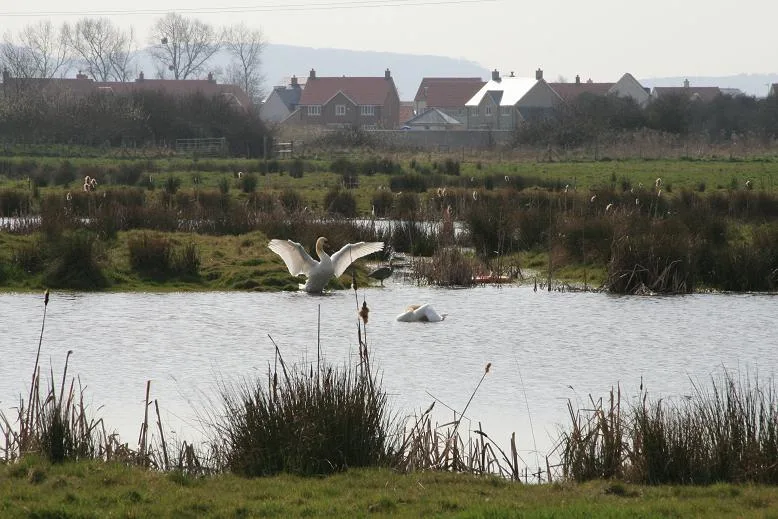
- Site of Special Scientific Interest: Severn Estuary SSSI
- Ramsar wetland: Severn Estuary
Designations sourced from Natural England open data under OGL v3.
From the Wikipedia article
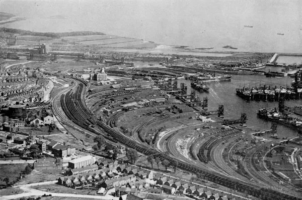
The Port of Bristol comprises the commercial, and former commercial, docks situated in and near the city of Bristol in England. The Port of Bristol Authority was the commercial title of the Bristol City, Avonmouth, Portishead and Royal Portbury Docks when they were operated by Bristol City Council, which ceased trade when the Avonmouth and Royal Portbury Docks were leased to The Bristol Port Company in 1991.
Excerpt from Wikipedia under CC BY-SA 4.0. See the source article linked in Sources below.
Background
History
The Port of Bristol grew up on the banks of the Rivers Avon and Frome, at their confluence upstream of the Avon Gorge which connects the city with the Severn Estuary and Bristol Channel. This part of the port was known as the Bristol City Docks, and is now more usually known as Bristol Harbour. The Avon and Frome are small, shallow rivers incapable in themselves of accommodating ocean-going ships, even those of the age of sail, as can still be seen by inspecting the branch of the Avon known as the New Cut at low tide. The harbour depended on the extreme tides () experienced in the Bristol Channel. Ships that wished to enter the harbour waited for the tide to begin to rise and floated up the…
Sourced from Wikipedia under CC BY-SA 4.0.
- Coordinates
- 51.5033, -2.7162
- District
- Bristol, City of
- Parish
- Bristol, City of, unparished area
- Postcode
- BS11 9AT
- Parliamentary constituency
- Bristol North West
- Nearest railway station
- Avonmouth — 1.3 km
Sources
- wikidata: Q7231091 (CC0)
- wikipedia: Port of Bristol (CC BY-SA 4.0)
- commons: 14 Port of Bristol docks in Avonmouth aerial view with River Severn - Bristol UK.jpg (CC BY-SA 4.0)
Other places nearby
Loading nearby places…
Nearby
 📷 5
📷 5Harbours & ports · South Wales
Avonmouth
Avonmouth — port, suburb and former electoral ward in Bristol, England.
 📷 3
📷 3Historic bridges · South Wales
Avonmouth Bridge
Avonmouth Bridge is a historic bridge in the United Kingdom.
 📷 3
📷 3Memorials & monuments · South Wales
Avonmouth Bridge Workers Memorial
Avonmouth Bridge Workers Memorial — a memorial in wales-south, United Kingdom.
 📷 3
📷 3Wildlife reserves · South Wales
Portbury Ashlands
Portbury Ashlands — nature reserve in United Kingdom.
 📷 3
📷 3Public art & sculpture · South Wales
Stronghold
Stronghold — a public art in wales-south, United Kingdom.
.jpg?width=1200) 📷 3
📷 3Forests & woodlands · South Wales
Lamplighter's Marsh Nature Reserve
Lamplighter's Marsh Nature Reserve is a forest or woodland in the United Kingdom.
More places in this region
 Flagship📷 5
Harbours & ports · South Wales
Barry Docks
Barry Docks is a harbour in the United Kingdom.
📷 5Harbours & ports · South Wales
Avonmouth
Avonmouth — port, suburb and former electoral ward in Bristol, England.
 📷 3
📷 3Harbours & ports · South Wales
Barry Harbour
Barry Harbour — former harbour in Barry, Vale of Glamorgan.
 📷 5
📷 5Harbours & ports · South Wales
Bristol Harbour
Bristol Harbour — harbour in the city of Bristol, England.
Frequently asked questions
- Where is Port of Bristol?
- Port of Bristol is in South Wales, United Kingdom (postcode BS11 9AT), in the parish of Bristol, City of, unparished area.
- Is Port of Bristol a protected site?
- Yes — Port of Bristol is part of the Severn Estuary SSSI Site of Special Scientific Interest and the Severn Estuary Ramsar wetland.
- How do I get to Port of Bristol?
- The nearest railway station is Avonmouth, about 1.3 km away. Drivers can navigate to postcode BS11 9AT.