Harbours & ports · South Wales
Cardiff Docks
Cardiff Docks is a harbour in the United Kingdom.

Wikimedia Commons contributors — see linked file page for photographer and licence licence
Plan your visit
- Typical visit
- 45 min–1.5 h
- Nearest railway station
- Cardiff Bay · 0.9 km
- Family-friendly
- Dog-friendly
About
Cardiff Docks is a harbour in the United Kingdom. Owned by Associated British Ports. Coordinates: 51.4653°, -3.1538°. This entry is part of The Great Britain Guide, a free, ad-free, open-data tourist directory.
Photo gallery
Protected designations
- Ramsar wetland: Severn Estuary
Designations sourced from Natural England open data under OGL v3.
From the Wikipedia article
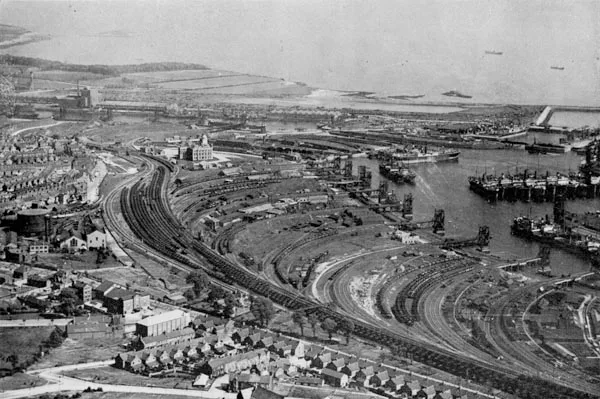
Cardiff Docks (Welsh: Dociau Caerdydd) is a port in southern Cardiff, Wales. At its peak, the port was one of the largest dock systems in the world with a total quayage of almost 7 mi (11 km). Once the main port for the export of South Wales coal, the Port of Cardiff remains active in the import and export of containers, steel, forest products and dry and liquid bulks.
Excerpt from Wikipedia under CC BY-SA 4.0. See the source article linked in Sources below.
Background
History
Following the development of the coal found in the Cynon Valley, Rhondda Valley, and Merthyr areas of South Wales, the export of both coal and iron products required a sea connection to the Bristol Channel if economic volumes of product were to be extracted. In 1794, the Glamorganshire Canal was completed, linking the then small town of Cardiff with Merthyr, and in 1798 a basin was built, connecting the canal to the sea. By the 1830s, Cardiff became the pre-eminent iron-exporting port, shipping almost half of British overseas iron exports; between 1840 and 1870, the volume of coal exports increased from 44,350 to 2.219 million tonnes.
Sourced from Wikipedia under CC BY-SA 4.0.
- Coordinates
- 51.4653, -3.1538
- District
- Cardiff
- Parish
- Butetown
- Postcode
- CF10 4NR
- Parliamentary constituency
- Cardiff South and Penarth
- Established
- 1839
- Nearest railway station
- Cardiff Bay — 0.9 km
- Official site
- web.archive.org
Sources
- wikidata: Q5038407 (CC0)
- wikipedia: Cardiff Docks (CC BY-SA 4.0)
- commons: Cranes and Sheds at Queen Alexandra Dock - geograph.org.uk - 1375866.jpg (CC BY-SA 4.0)
Other places nearby
Loading nearby places…
Nearby
 📷 5
📷 5Public art & sculpture · South Wales
Queen's Gate
Queen's Gate — a public art in wales-south, United Kingdom.
 📷 3
📷 3Public art & sculpture · South Wales
From Pit to Port
From Pit to Port — a public art in wales-south, United Kingdom.
 📷 3
📷 3Public art & sculpture · South Wales
The Heart of Wales
The Heart of Wales — a public art in wales-south, United Kingdom.
 📷 3
📷 3Public art & sculpture · South Wales
The Meeting Place on the Plinth
The Meeting Place on the Plinth — a public art in wales-south, United Kingdom.
 📷 3
📷 3Theatres · South Wales
BBC Hoddinott Hall
BBC Hoddinott Hall is a theatre in the United Kingdom.
 📷 3
📷 3Theatres · South Wales
Donald Gordon Theatre
Donald Gordon Theatre is a theatre in the United Kingdom.
More places in this region
 Flagship📷 5
Harbours & ports · South Wales
Barry Docks
Barry Docks is a harbour in the United Kingdom.
 📷 5
📷 5Harbours & ports · South Wales
Avonmouth
Avonmouth — port, suburb and former electoral ward in Bristol, England.
 📷 3
📷 3Harbours & ports · South Wales
Barry Harbour
Barry Harbour — former harbour in Barry, Vale of Glamorgan.
 📷 5
📷 5Harbours & ports · South Wales
Bristol Harbour
Bristol Harbour — harbour in the city of Bristol, England.
Frequently asked questions
- Where is Cardiff Docks?
- Cardiff Docks is in South Wales, United Kingdom (postcode CF10 4NR), in the parish of Butetown.
- When was Cardiff Docks built?
- Built or established in 1839.
- Who owns Cardiff Docks?
- Cardiff Docks is owned by Associated British Ports.
- Is Cardiff Docks a protected site?
- Yes — Cardiff Docks is part of the Severn Estuary Ramsar wetland.
- How do I get to Cardiff Docks?
- The nearest railway station is Cardiff Bay, about 0.9 km away. Drivers can navigate to postcode CF10 4NR.