Mountains & hills · West Midlands
Worcestershire Beacon
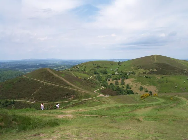
Worcestershire Beacon — Named summit at 425 m.
Wikimedia Commons contributors — see linked file page for photographer and licence licence
Plan your visit
- Typical visit
- 3 h–8 h
- Best time of year
- Late spring – early autumn (May–Oct)
- Nearest railway station
- Great Malvern · 1.5 km
- Free entry
- Dog-friendly
About
Worcestershire Beacon is a named summit in the United Kingdom. Wikidata describes it as: "Named summit at 425 m.". Coordinates: 52.1048°, -2.3390°.
Photo gallery
Protected designations
- Site of Special Scientific Interest: The Malvern Hills SSSI
- Area of Outstanding Natural Beauty: Cotswolds
- Area of Outstanding Natural Beauty: Malvern Hills
Designations sourced from Natural England open data under OGL v3.
From the Wikipedia article
Worcestershire Beacon, also popularly known as Worcester Beacon, or locally simply as The Beacon, is a hill whose summit at 425 metres (1,394 ft) is the highest point in Worcestershire. It is part of the Malvern Hills which run about 13 kilometres (8.1 mi) north-south along the Herefordshire-Worcestershire border. The hills are managed by the Malvern Hills Conservators under five Acts of Parliament of 1884, 1909, 1924, 1930, and 1995 whose aim is to preserve the nature and environment landscape of the area and to protect it from encroachments. The Beacon is highly popular with walkers with its easily reached dense network of footpaths crisscrossing it and the area has been designated by the Countryside Agency as an Area of Outstanding Natural Beauty.
Excerpt from Wikipedia under CC BY-SA 4.0. See the source article linked in Sources below.
Background
History
and erected to commemorate Queen Victoria's Diamond Jubilee in 1897]] The hill itself appears to mark the northern terminal of the Shire Ditch, or Red Earl's Dyke, which runs north and south of the British Camp along the ridge of the hills. It was created in 1287 by Gilbert de Clare, the Earl of Gloucester, following a boundary dispute with Thomas de Cantilupe, the Bishop of Hereford. Recent research has shown that the Shire Ditch might actually be much older. Indeed, there is some evidence that it may have started life as a prehistoric trackway running from Worcestershire Beacon to Midsummer Hillfort. The hill is also the site of two Bronze Age burials. In 1849 two urns containing bones…
Sourced from Wikipedia under CC BY-SA 4.0.
- Coordinates
- 52.1048, -2.3390
- County
- Worcestershire
- District
- Malvern Hills
- Parish
- West Malvern
- Postcode
- WR14 4DG
- Parliamentary constituency
- West Worcestershire
- Nearest railway station
- Great Malvern — 1.5 km
- Official site
- www.hill-bagging.co.uk
Sources
- osm: n96072663 (ODbL)
- wikipedia: Worcestershire Beacon (CC BY-SA 4.0)
- commons: Worcestershire Beacon - geograph.org.uk - 1488388.jpg (CC BY-SA 4.0)
Other places nearby
Loading nearby places…
Nearby
Mountain bike trails · West Midlands
Malvern Hills Medium Mountain Bike Trail
Malvern Hills Medium Mountain Bike Trail — a mtb trail in england west midlands.
 📷 3
📷 3Mountains & hills · West Midlands
Sugarloaf Hill
Sugarloaf Hill — Named summit at 369 m.
 📷 4
📷 4Historic churches · West Midlands
St. Ann's Well, Malvern
St. Ann's Well is set on the slopes of the Malvern Hills above Great Malvern. It is a popular site on a path leading up to the Worcestershire Beacon and lies on the final descent of the Worcestershire
 📷 4
📷 4Public art & sculpture · West Midlands
The Lark Ascending
The Lark Ascending — a public art in england-west-midlands, United Kingdom.
 📷 3
📷 3Public art & sculpture · West Midlands
Malvern Buzzards
Malvern Buzzards — a public art in england-west-midlands, United Kingdom.
 📷 3
📷 3Memorials & monuments · West Midlands
Wilson Memorial
Wilson Memorial — a memorial in england-west-midlands, United Kingdom.
More mountains in this region
 📷 5
📷 5Mountains & hills · West Midlands
Arbury Hill
Arbury Hill — Named summit at 224.3 m.
Mountains & hills · West Midlands
Barr Beacon
Barr Beacon — Named summit at 227 m.
 📷 3
📷 3Mountains & hills · West Midlands
Barrow Hill
Barrow Hill — Named summit at 179 m.
Mountains & hills · West Midlands
Beacon Hill
Beacon Hill — Named summit at 237 m.
Frequently asked questions
- Where is Worcestershire Beacon?
- Worcestershire Beacon is in Worcestershire, the West Midlands, United Kingdom (postcode WR14 4DG), in the parish of West Malvern.
- Is Worcestershire Beacon a protected site?
- Yes — Worcestershire Beacon is part of the The Malvern Hills SSSI Site of Special Scientific Interest and the Cotswolds National Landscape (AONB).
- Is Worcestershire Beacon free to visit?
- Yes, Worcestershire Beacon is free to enter.
- How do I get to Worcestershire Beacon?
- The nearest railway station is Great Malvern, about 1.5 km away. Drivers can navigate to postcode WR14 4DG.