Hill forts · Mid Wales
Whetstones
Whetstones — ancient pagan monument in Powys, Wales, UK.

Wikimedia Commons licence
Plan your visit
- Typical visit
- 1 h–2 h
- Free entry
- Dog-friendly
About
Whetstones is a hill fort in the United Kingdom. Wikidata describes it as: "ancient pagan monument in Powys, Wales, UK". Coordinates: 52.5711°, -3.0280°.
Photo gallery
Protected designations
- Area of Outstanding Natural Beauty: Shropshire Hills
Designations sourced from Natural England open data under OGL v3.
From the Wikipedia article
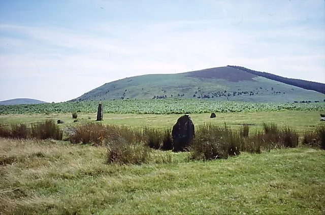
The Whetstones are, or were, a stone circle beneath Corndon Hill in the parish of Church Stoke, Montgomeryshire, Wales, near the border with Shropshire, England. They lie immediately to the west of the village of White Grit and close to Priestweston. The site is also a short distance from the better-known Hoarstones and Mitchell's Fold circles.
Excerpt from Wikipedia under CC BY-SA 4.0. See the source article linked in Sources below.
Background
History
The Reverend C. H. Hartshorne visited the site in 1841, commenting that three stones then remained, all leaning. He referred to these as being "mutilated fragments" of the ring's original appearance. He described the stones as "leaning, owing to the soft and boggy nature of the soil. They stand equidistant and assume a circular position [...] The highest of these is four feet above the surface; one foot six inches in thickness, and three feet in width." In 1860, the antiquarian Robert William Eyton still referred to the Whetstones as a "remarkable monument", but they were later stated to have been dug up, and the stones incorporated into a boundary wall, in about 1870. Most of the stones in…
Description
Burl estimated that Whetstones circle had had a major axis of 30 metres, in which case it would have been a large stone circle. Three stones were reported as being extant in 1841, the largest being 1.2 metres long. No information on the shape of the circle survives.
Sourced from Wikipedia under CC BY-SA 4.0.
- Coordinates
- 52.5711, -3.0280
- District
- Powys
- Parish
- Churchstoke
- Postcode
- SY5 0JJ
- Parliamentary constituency
- Montgomeryshire and Glyndwr
Sources
- wikidata: Q7993529 (CC0)
- wikipedia: Whetstones (stone circle) (CC BY-SA 4.0)
Other places nearby
Loading nearby places…
Nearby
 📷 3
📷 3Mountains & hills · Mid Wales
Corndon Hill
Corndon Hill — Named summit at 513 m.
 📷 4
📷 4Other places · Mid Wales
River Onny
River Onny in Wales Mid, United Kingdom.
 📷 3
📷 3Archaeological sites · Mid Wales
Mitchell's Fold stone circle, standing stone and cairn 280m south west of Mitchell's Fold
Mitchell's Fold stone circle, standing stone and cairn 280m south west of Mitchell's Fold — archaeological site in Chirbury with Brompton, Shropshire, England, UK.
 📷 5
📷 5Memorials & monuments · Mid Wales
Mitchell's Fold
Mitchell's Fold in Wales Mid, United Kingdom.
 📷 3
📷 3Castles · Mid Wales
White Grit
White Grit in Wales Mid, United Kingdom.
 📷 4
📷 4Mountains & hills · Mid Wales
Stapeley Hill
Stapeley Hill in Wales Mid, United Kingdom.
More places in this region
 📷 5
📷 5Hill forts · Mid Wales
Arthur's Stone, Herefordshire
Arthur's Stone, Herefordshire is a hill fort in the United Kingdom.
 📷 3
📷 3Hill forts · Mid Wales
Aymestrey burial
Aymestrey burial — Beaker cist discovered in Herefordshire, England.
 📷 3
📷 3Hill forts · Mid Wales
Bedd Taliesin
Bedd Taliesin — listed Historic Monument and grave.
 📷 3
📷 3Hill forts · Mid Wales
Bremia
Bremia — archaeological site in Ceredigion, Wales, UK.
Frequently asked questions
- Where is Whetstones?
- Whetstones is in Mid Wales, United Kingdom (postcode SY5 0JJ), in the parish of Churchstoke.
- Is Whetstones a protected site?
- Yes — Whetstones is part of the Shropshire Hills National Landscape (AONB).
- Is Whetstones free to visit?
- Yes, Whetstones is free to enter.
- How do I get to Whetstones?
- Drivers can navigate to postcode SY5 0JJ. It sits within the Montgomeryshire and Glyndwr parliamentary constituency.