Reservoirs & lochs · West Midlands
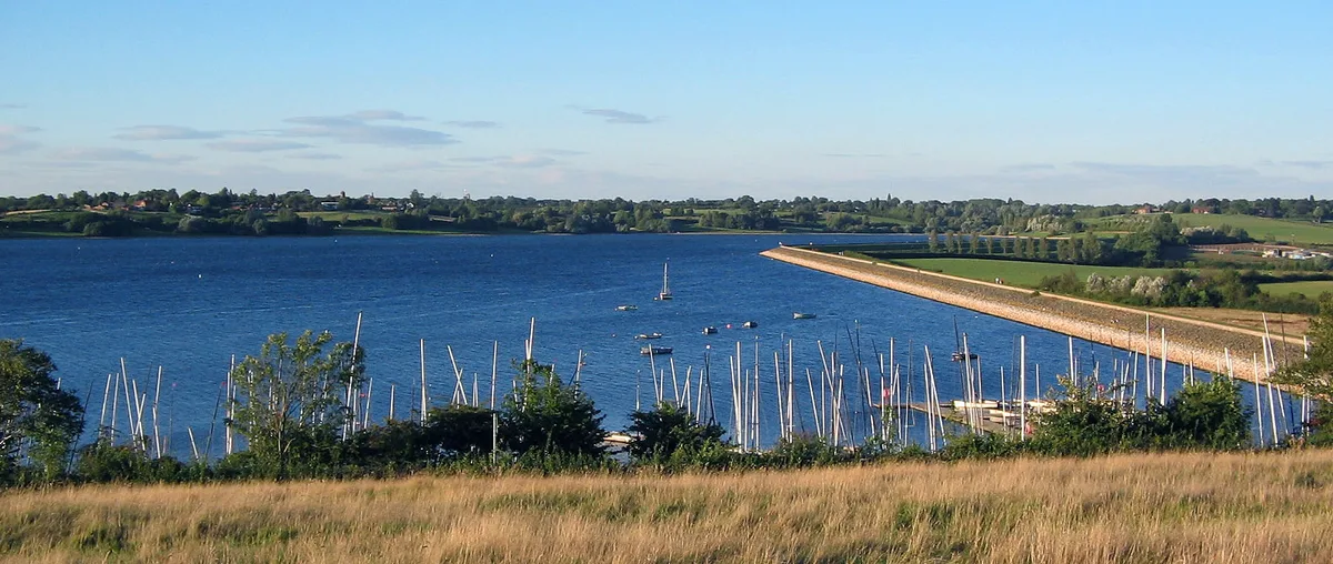
Thornton Reservoir
Thornton Reservoir — lake in the United Kingdom.

Wikimedia Commons contributors — see linked file page for photographer and licence licence
Plan your visit
- Typical visit
- 1 h–2.5 h
- Nearest railway station
- Market Bosworth · 9.1 km
- Free entry
- Dog-friendly
About
Thornton Reservoir is a reservoir in the United Kingdom. Wikidata describes it as: "lake in the United Kingdom". Coordinates: 52.6639°, -1.3022°.
Photo gallery
From the Wikipedia article
Thornton Reservoir is a small reservoir situated in the National Forest near the village of Thornton in Leicestershire. It has a surface area of 75 acres (300,000 m2) and a perimeter of 2.45 miles (3.94 km). It was originally built in 1854 when it had its own treatment works which were situated to the south of the current dam. It is now owned by Severn Trent and the water is treated a few miles away at Cropston Reservoir to which it runs via Rothley Brook. The reservoir is fed by two small streams which enter from the north via two weirs. Rothley Brook takes water away from the south. Since 1997 the reservoir and the surrounding land has been open to the public. Facilities include a small visitor centre, a sculpture trail, a woodland walk and a (now closed) trout fishery. The National Cycle Network runs around the reservoir. Planning for the reservoir began in 1847. The design included a dam where Locky Bridge had previously stood, the reservoir fed by Carr Brook and Thornton Brook. Behind the dam were two filtration tanks, and from there the water was carried via gravitation to a storage reservoir in Oadby. Supply from the reservoir began in 1853, with Thomas Cook's Temperance Hall the first building to receive water from it. The reservoir was thought sufficient to serve Leicester's population of 58,000 at the time, delivering 1.6 million gallons per day, and was the main source of water for the city until the opening of Bradgate Reservoir in 1871. The surface area was originally calculated at 55 acres with the capacity 229 million gallons. The estimated cost of building the reservoir was £80,000. The reservoir was taken out of use in 1982, but was opened up to the public in 1997, with paths around the edge and the closed trout fishery on the west bank.
Excerpt from Wikipedia under CC BY-SA 4.0. See the source article linked in Sources below.
- Coordinates
- 52.6639, -1.3022
- County
- Leicestershire
- District
- Hinckley and Bosworth
- Parish
- Bagworth & Thornton
- Postcode
- LE67 1AR
- Parliamentary constituency
- Mid Leicestershire
- Nearest railway station
- Market Bosworth — 9.1 km
Sources
- wikidata: Q7349099 (CC0)
- wikipedia: Thornton Reservoir (CC BY-SA 4.0)
- commons: ThorntonReservoir.jpg (CC BY-SA 4.0)
Other places nearby
Loading nearby places…
Nearby
 📷 3
📷 3Historic churches · West Midlands
Church of St Peter
Church of St Peter — church in Thornton, Leicestershire, England, UK.
 📷 4
📷 4Country parks · East Midlands
Bagworth Heath Woods
Bagworth Heath Woods is a 75-hectare (185-acre) country park on the location of the former Desford Colliery, in Leicestershire, England consisting of woodland, grassland, heathland, lakes and ponds. T
Caravan parks · West Midlands
Charnwood Acres Park
Charnwood Acres Park — a caravan park in england west midlands.
 📷 3
📷 3Memorials & monuments · West Midlands
War Memorial North of Polebrook House at Ngr 484058
War Memorial North of Polebrook House at Ngr 484058 — Grade II listed building-listed memorial in england-west-midlands, United Kingdom.
 📷 3
📷 3Memorials & monuments · West Midlands
Bagworth War Memorial
Bagworth War Memorial — Grade II listed building-listed memorial in england-west-midlands, United Kingdom.
 📷 5
📷 5Historic churches · West Midlands
The Markfield Mosque
The Markfield Mosque — a church in england-west-midlands, United Kingdom.
More places in this region
 Flagship📷 3
Reservoirs & lochs · West Midlands
Draycote Water
Draycote Water — reservoir in the United Kingdom.
 Flagship📷 3
Reservoirs & lochs · West Midlands
Netherton Reservoir
Netherton Reservoir — reservoir in West Midlands, England, UK.
 📷 3
📷 3Reservoirs & lochs · West Midlands
Abingdon Reservoir
Abingdon Reservoir — proposed reservoir in Oxfordshire, England, UK.
 📷 3
📷 3Reservoirs & lochs · West Midlands
Aston Reservoir
Aston Reservoir — reservoir in Birmingham, West Midlands, England, UK.
Frequently asked questions
- Where is Thornton Reservoir?
- Thornton Reservoir is in West Midlands, in the United Kingdom — coordinates 52.6639°, -1.3022°. The nearest railway station is Market Bosworth, around 9.1 km away.
- Is Thornton Reservoir free to visit?
- Yes — admission to Thornton Reservoir is free.