Mountains & hills · Mid Wales
Stiperstones
Also known as: Carneddau Teon
Stiperstones — Named summit at 536.9 m.

Wikimedia Commons contributors — see linked file page for photographer and licence licence
Plan your visit
- Typical visit
- 3 h–8 h
- Best time of year
- Late spring – early autumn (May–Oct)
- Free entry
- Family-friendly
- Dog-friendly
About
Stiperstones is a named summit in the United Kingdom. Also known as: Carneddau Teon. Wikidata describes it as: "Named summit at 536.9 m.". Coordinates: 52.5820°, -2.9350°.
Photo gallery
Protected designations
- Site of Special Scientific Interest: The Stiperstones & The Hollies SSSI
- National Nature Reserve: STIPERSTONES LANDSCAPE
- Area of Outstanding Natural Beauty: Shropshire Hills
Designations sourced from Natural England open data under OGL v3.
From the Wikipedia article
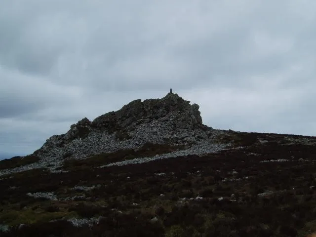
The Stiperstones (Welsh: Carneddau Teon) is a distinctive hill in Shropshire, England. The quartzite rock of the ridge formed some 480 million years ago. During the last Ice Age Stiperstones lay on the eastern margin of the Welsh ice sheet. The hill itself was not glaciated though glaciers occupied surrounding valleys and it was subject to intense freezing and thawing which shattered the quartzite into a mass of jumbled scree surrounding several residual rocky tors. At 536 metres (1,759 ft) above sea level it is the second-highest hill in the county, surpassed only by Brown Clee Hill (540 metres (1,772 ft)). Stiperstones' 8-kilometre (5 mi) summit ridge is crowned by several jagged outcrops of rock, which may be seen silhouetted against the sky.
Excerpt from Wikipedia under CC BY-SA 4.0. See the source article linked in Sources below.
- Coordinates
- 52.5820, -2.9350
- District
- Shropshire
- Parish
- Worthen with Shelve
- Postcode
- SY5 0NF
- Parliamentary constituency
- South Shropshire
Sources
- osm: n390224707 (ODbL)
- wikipedia: Stiperstones (CC BY-SA 4.0)
- commons: Stiperstones.jpg (CC BY-SA 4.0)
Other places nearby
Loading nearby places…
Nearby
 📷 4
📷 4Natural landmarks · Mid Wales
Stiperstones
Stiperstones — hill in Shropshire, United Kingdom.
 📷 3
📷 3Natural landmarks · Mid Wales
Manstone Rock
Manstone Rock — a other in wales-mid, United Kingdom.
 📷 4
📷 4Other places · Mid Wales
Wild Edric's Way
Wild Edric's Way in Wales Mid, United Kingdom.
 📷 3
📷 3Natural landmarks · Mid Wales
Devil's Chair
Devil's Chair — a other in wales-mid, United Kingdom.
 📷 3
📷 3Natural landmarks · Mid Wales
Cranberry Rock
Cranberry Rock — a other in wales-mid, United Kingdom.
 📷 3
📷 3Natural landmarks · Mid Wales
The Bog Visitor Centre
The Bog Visitor Centre — a natural landmark in wales-mid, United Kingdom.
More mountains in this region
 📷 3
📷 3Mountains & hills · Mid Wales
Black Hill
Black Hill — Named summit at 640 m.
 📷 3
📷 3Mountains & hills · Mid Wales
Black Mixen
Black Mixen — Named summit at 650 m.
 📷 5
📷 5Mountains & hills · Mid Wales
Cadair Idris
Cadair Idris — Named summit at 893 m.
 📷 3
📷 3Mountains & hills · Mid Wales
Caer Caradoc
Caer Caradoc — Named summit at 459 m.
Frequently asked questions
- Where is Stiperstones?
- Stiperstones is in Mid Wales, United Kingdom (postcode SY5 0NF), in the parish of Worthen with Shelve.
- Is Stiperstones a protected site?
- Yes — Stiperstones is part of the The Stiperstones & The Hollies SSSI Site of Special Scientific Interest and the STIPERSTONES LANDSCAPE National Nature Reserve.
- Is Stiperstones free to visit?
- Yes, Stiperstones is free to enter.
- How do I get to Stiperstones?
- Drivers can navigate to postcode SY5 0NF. It sits within the South Shropshire parliamentary constituency.