Natural landmarks · Northern Ireland
Slieve Gallion
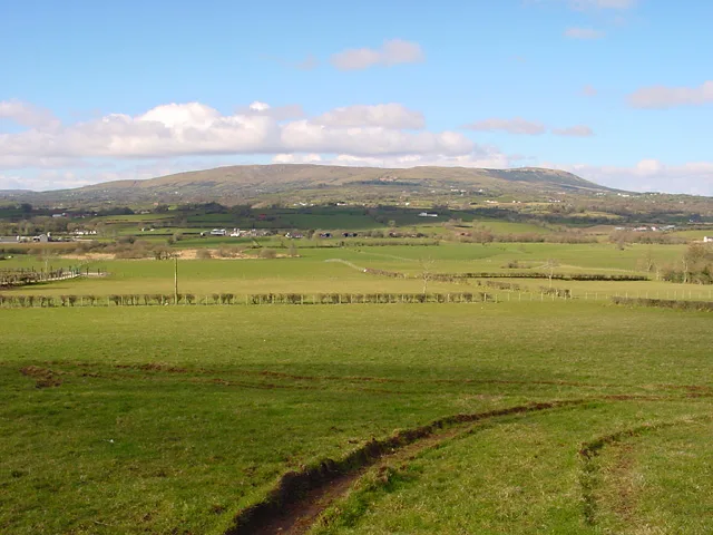
Slieve Gallion — mountain in Northern Ireland.

Wikimedia Commons contributors — see linked file page for photographer and licence licence
Plan your visit
- Typical visit
- 1 h–2 h
- Free entry
- Dog-friendly
About
Slieve Gallion is a named natural landmark in the United Kingdom. Wikidata describes it as: "mountain in Northern Ireland". Coordinates: 54.7300°, -6.7600°.
Photo gallery
From the Wikipedia article
Slieve Gallion (Irish: Sliabh gCallann) is a mountain in County Londonderry, Northern Ireland. It is the easternmost of the Sperrin Mountains. It reaches a height of 528 metres (1,732 ft) and dominates the western shore of Lough Neagh. Its prominent northeastern summit has a transmitter station with a small road leading to it, and stands at a height of 496 metres (1,627 ft). By road, Slieve Gallion is 4 miles (6.4 km) from Moneymore, 8 miles (13 km) from Cookstown, and 8 miles (13 km) from Magherafelt. The mountain is part of the parishes of Desertmartin, Lissan and Ballinascreen.
Excerpt from Wikipedia under CC BY-SA 4.0. See the source article linked in Sources below.
Background
History
The earliest reference to Slieve Gallion is from the 7th century, in the Book of Armagh, where it is called , likely meaning "the height of Saint Patrick". This later became Sliabh gCallann, the first element meaning "mountain". A folk etymology is that it means "Callan's mountain", and legend has it that a giant named Callann Mór is buried at Carnanbane on the west side of the mountain. From the Middle Ages until the 20th century, gatherings were held on the mountain to mark the festival of Lughnasadh. In recent decades, there has been an increase in the number of sheep grazing in the area, as well as an increase in mountain biking and hill walking, contributing to erosion.
Sourced from Wikipedia under CC BY-SA 4.0.
- Coordinates
- 54.7300, -6.7600
- Address
- County Londonderry, Northern Ireland
Sources
- wikidata: Q7540432 (CC0)
- wikipedia: Slieve Gallion (CC BY-SA 4.0)
- commons: Slievegallion.jpg (CC BY-SA 4.0)
Other places nearby
Loading nearby places…
Nearby
 📷 3
📷 3Mountains & hills · Northern Ireland
Slieve Gallion
Slieve Gallion — Named summit at 526.6 m.
 📷 4
📷 4Natural landmarks · Northern Ireland
Ulster
Ulster in Northern Ireland, United Kingdom.
 📷 5
📷 5Memorials & monuments · Northern Ireland
Neolithic Ritural Complex
Neolithic Ritural Complex — a memorial in northern-ireland, United Kingdom.
 📷 3
📷 3Hill forts · Northern Ireland
Corick
Corick — archaeological site in United Kingdom.
 📷 3
📷 3Natural landmarks · Northern Ireland
Mid Ulster
Mid Ulster in Northern Ireland, United Kingdom.
Vineyards · Northern Ireland
Tintagh
Tintagh — a UK vineyard in northern ireland, producing English or Welsh wine from cool-climate grape varieties.
More natural landmarks in this region
 Flagship📷 4
Natural landmarks · Northern Ireland
Lough Erne
Lough Erne — lake in County Fermanagh, Northern Ireland, UK.
 Flagship📷 4
Natural landmarks · Northern Ireland
Lough Neagh
Lough Neagh — large lake in Northern Ireland.
 📷 3
📷 3Natural landmarks · Northern Ireland
Ballysaggart Lough
Ballysaggart Lough — lake in the United Kingdom.
 📷 5
📷 5Natural landmarks · Northern Ireland
Belmore Mountain
Belmore Mountain — mountain in the United Kingdom.
Frequently asked questions
- Where is Slieve Gallion?
- Slieve Gallion is in Northern Ireland, in the United Kingdom — coordinates 54.7300°, -6.7600°.
- Is Slieve Gallion free to visit?
- Yes — admission to Slieve Gallion is free.