Mountains & hills · Scottish Highlands
Sgurr a' Chaorachain
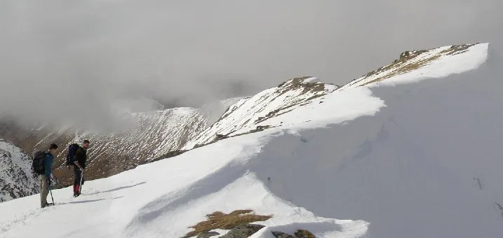
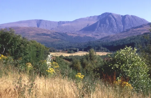
Sgurr a' Chaorachain — Named summit at 1053 m.

Wikimedia Commons contributors — see linked file page for photographer and licence licence
Plan your visit
- Typical visit
- 3 h–8 h
- Best time of year
- Late spring – early autumn (May–Oct)
- Nearest railway station
- Achnashellach · 9.2 km
- Free entry
- Dog-friendly
About
Sgurr a' Chaorachain is a named summit in the United Kingdom. Wikidata describes it as: "Named summit at 1053 m.". Coordinates: 57.4526°, -5.1893°.
Photo gallery
From the Wikipedia article
Sgùrr a' Chaorachain (Scottish Gaelic: Sgùrr a' Chaorthachain) is a mountain with a height of 1,053 metres (3,455 ft) in the Northwest Highlands, Scotland. It lies in Wester Ross. A remote mountain, it is near the Glen Carron, and at the head of Loch Monar.
Excerpt from Wikipedia under CC BY-SA 4.0. See the source article linked in Sources below.
- Coordinates
- 57.4526, -5.1893
- Address
- Wester Ross, Scotland
- Nearest railway station
- Achnashellach — 9.2 km
- Official site
- www.hill-bagging.co.uk
Sources
- osm: n269514445 (ODbL)
- wikipedia: Sgùrr a' Chaorachain (Munro) (CC BY-SA 4.0)
- commons: Sgùrr a' Chaorachain - geograph.org.uk - 1581324.jpg (CC BY-SA 4.0)
Other places nearby
Loading nearby places…
Nearby
 📷 3
📷 3Mountains & hills · Scottish Highlands
Sgùrr Choinnich
Sgùrr Choinnich — Named summit at 999 m.
 📷 3
📷 3Natural landmarks · Scottish Highlands
Sgùrr Choinnich
Sgùrr Choinnich — 999m high mountain in Highland, Scotland, UK.
 📷 3
📷 3Mountains & hills · Scottish Highlands
Sgurr a' Chaorachain - Bidean an Eoin Deirg
Sgurr a' Chaorachain - Bidean an Eoin Deirg — a mountain in scotland-highlands, United Kingdom.
 📷 3
📷 3Mountains & hills · Scottish Highlands
Sgurr Choinnich - Sgurr na Conbhaire
Sgurr Choinnich - Sgurr na Conbhaire — a mountain in scotland-highlands, United Kingdom.
 📷 3
📷 3Natural landmarks · Scottish Highlands
Sgùrr nan Ceannaichean
Sgùrr nan Ceannaichean — mountain in Highland, Scotland, UK.
 📷 4
📷 4Mountains & hills · Scottish Highlands
Sgùrr na Feartaig
Sgùrr na Feartaig in Scotland Islands, United Kingdom.
More mountains in this region
 📷 3
📷 3Mountains & hills · Scottish Highlands
A' Bhuidheanach Bheag
A' Bhuidheanach Bheag — Named summit at 936 m.
 📷 3
📷 3Mountains & hills · Scottish Highlands
A' Chailleach
A' Chailleach — Named summit at 997 m.
 📷 3
📷 3Mountains & hills · Scottish Highlands
A' Chailleach
A' Chailleach — Named summit at 930 m.
 📷 3
📷 3Mountains & hills · Scottish Highlands
A' Chaoirnich
A' Chaoirnich — Named summit at 875 m.
Frequently asked questions
- Where is Sgurr a' Chaorachain?
- Sgurr a' Chaorachain is in Scottish Highlands, in the United Kingdom — coordinates 57.4526°, -5.1893°. The nearest railway station is Achnashellach, around 9.2 km away.
- Is Sgurr a' Chaorachain free to visit?
- Yes — admission to Sgurr a' Chaorachain is free.