Mountains & hills · Scottish Highlands
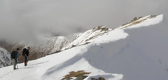
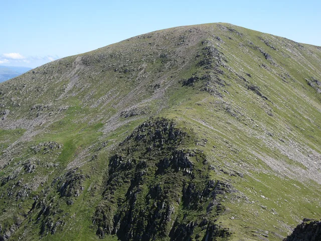
Sgùrr Choinnich
Also known as: Sgurr Choinnich
Sgùrr Choinnich — Named summit at 999 m.

Wikimedia Commons contributors — see linked file page for photographer and licence licence
Plan your visit
- Typical visit
- 3 h–8 h
- Best time of year
- Late spring – early autumn (May–Oct)
- Nearest railway station
- Achnashellach · 8.3 km
- Free entry
- Dog-friendly
About
Sgùrr Choinnich is a named summit in the United Kingdom. Wikidata describes it as: "Named summit at 999 m.". Coordinates: 57.4510°, -5.2079°.
Photo gallery
From the Wikipedia article
Sgùrr Choinnich is a mountain with a height of 999 metres (3,278 ft) in the Northwest Highlands of Scotland. Classed as a Munro, it is in the Achnashellach Forest area between Glen Carron and Loch Monar. It has mostly steep, grassy slopes, with a narrow summit ridge that runs east–west. There are crags on the northern side of this ridge, looking down into the corrie of Coire Choinnich. From the summit there are fine views of the Coulin and Torridon peaks to the north, whilst southward lies a large expanse of wilderness around Loch Monar. The hill is often climbed along with the neighbouring Sgùrr a' Chaorachain, to the east, as the pair are linked by a high bealach at the head of Coire Choinnich. The most normal route of ascent starts from the north, near Craig, a small village in Glen Carron. A good track leads up the side of the Allt a' Chonais burn, and once across the burn one possible route of ascent is the north ridge of Sgùrr a' Chaorachain. From the summit of this peak one may continue west onto the summit of Sgùrr Choinnich. From the east, a well defined ridge leads to the bealach of Bealach Bhearnais; here a stalkers track leads from the glen of Allt a' Chonais is met, thus a circular route is possible. Alternatively from Bealach Bhearnais one may choose to ascend the neighbouring peaks of Beinn Tharsuinn and Sgùrr nan Feartaig.
Excerpt from Wikipedia under CC BY-SA 4.0. See the source article linked in Sources below.
- Coordinates
- 57.4510, -5.2079
- Address
- Achnashellach Forest, Scotland
- Nearest railway station
- Achnashellach — 8.3 km
- Official site
- www.walkhighlands.co.uk
Sources
- osm: n269514446 (ODbL)
- wikipedia: Sgùrr Choinnich (CC BY-SA 4.0)
- commons: Sgurr choinnich.jpg (CC BY-SA 4.0)
Other places nearby
Loading nearby places…
Nearby
 📷 3
📷 3Natural landmarks · Scottish Highlands
Sgùrr Choinnich
Sgùrr Choinnich — 999m high mountain in Highland, Scotland, UK.
 📷 3
📷 3Mountains & hills · Scottish Highlands
Sgurr a' Chaorachain
Sgurr a' Chaorachain — Named summit at 1053 m.
 📷 3
📷 3Mountains & hills · Scottish Highlands
Sgurr Choinnich - Sgurr na Conbhaire
Sgurr Choinnich - Sgurr na Conbhaire — a mountain in scotland-highlands, United Kingdom.
 📷 4
📷 4Mountains & hills · Scottish Highlands
Sgùrr na Feartaig
Sgùrr na Feartaig in Scotland Islands, United Kingdom.
 📷 3
📷 3Mountains & hills · Scottish Highlands
Sgurr a' Chaorachain - Bidean an Eoin Deirg
Sgurr a' Chaorachain - Bidean an Eoin Deirg — a mountain in scotland-highlands, United Kingdom.
 📷 3
📷 3Mountains & hills · Scottish Highlands
Sgurr na Feartaig North Top
Sgurr na Feartaig North Top — a mountain in scotland-highlands, United Kingdom.
More mountains in this region
 📷 3
📷 3Mountains & hills · Scottish Highlands
A' Bhuidheanach Bheag
A' Bhuidheanach Bheag — Named summit at 936 m.
 📷 3
📷 3Mountains & hills · Scottish Highlands
A' Chailleach
A' Chailleach — Named summit at 997 m.
 📷 3
📷 3Mountains & hills · Scottish Highlands
A' Chailleach
A' Chailleach — Named summit at 930 m.
 📷 3
📷 3Mountains & hills · Scottish Highlands
A' Chaoirnich
A' Chaoirnich — Named summit at 875 m.
Frequently asked questions
- Where is Sgùrr Choinnich?
- Sgùrr Choinnich is in Scottish Highlands, in the United Kingdom — coordinates 57.4510°, -5.2079°. The nearest railway station is Achnashellach, around 8.3 km away.
- Is Sgùrr Choinnich free to visit?
- Yes — admission to Sgùrr Choinnich is free.