Towns & cities · North West England
Sefton
Also known as: Sefton, Glannau Merswy
Sefton — village in the Metropolitan Borough of Sefton, in Merseyside, England.

Wikimedia Commons contributors — see linked file page for photographer and licence licence
Plan your visit
- Typical visit
- 3 h–6 h
- Nearest railway station
- Old Roan · 2.3 km
- Free entry
- Family-friendly
- Dog-friendly
About
Sefton is a town, city, village or settlement in the United Kingdom. Recent population estimates put it at around 772 people. Address: L29. Wikidata describes it as: "village in the Metropolitan Borough of Sefton, in Merseyside, England". Coordinates: 53.5040°, -2.9714°.
Photo gallery
Protected designations
- Ramsar wetland: Ribble & Alt Estuaries
Designations sourced from Natural England open data under OGL v3.
From the Wikipedia article
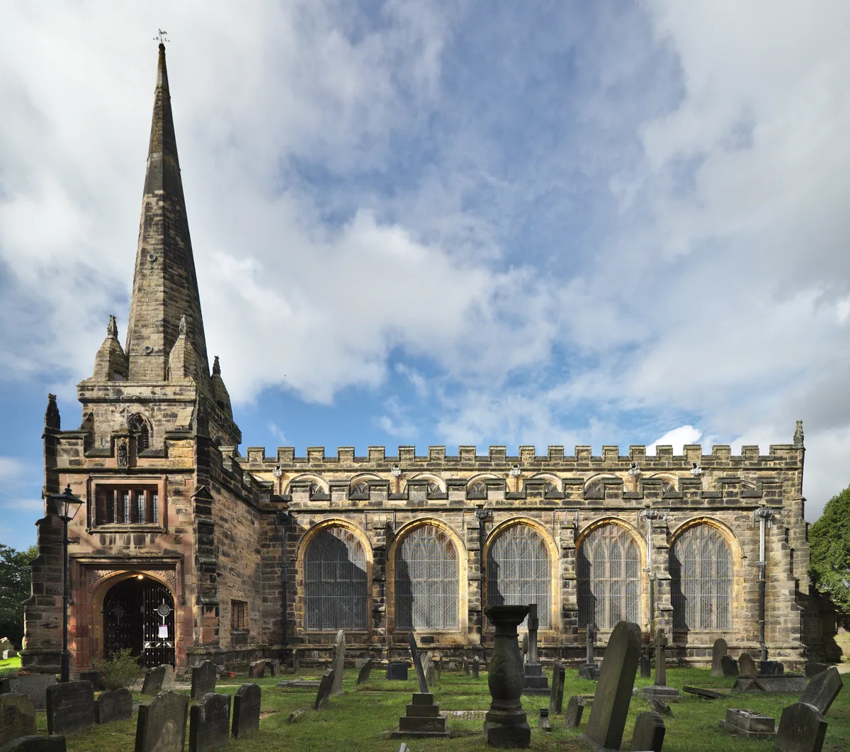
Sefton is a village and civil parish in the Metropolitan Borough of Sefton in Merseyside, England. Located to the south west of Maghull and to the north east of Great Crosby, it is on the flood plain of the River Alt. The village is bisected by the B5422, Brickwall Lane, which cuts also through the site of the moat of Sefton Old Hall, a recognised National Monument. At the 2001 Census the population was recorded as 772, increasing to 855 at the 2011 Census. Historically a part of Lancashire, the name Sefton is thought to be derived from the Old Norse sef, meaning "sedge" or "rushes" and tún meaning "farmstead". In the past Sephton was an alternative spelling. The Parish Church of St Helen (Church of England) – the only Grade I listed building in the Borough – was first built around 1170 as the private chapel of the Molyneux family. This village is home to Sefton Parish Church, Saint Helen's Well, a pre-Reformation shrine, a plague pot, the Grade II listed "Punch Bowl Inn" and the site of Sefton Mill dating back to the Middle Ages. Local folklore has it that Sefton Hall, a Royalist stronghold, was the scene of a skirmish in the English Civil War. The Georgian Rectory to nearby Sefton Parish Church was demolished in the 1970s, however the gate piers still stand at the entrance to Glebe End. The curate's house, Lunt House, was situated in the nearby hamlet of Lunt.
Excerpt from Wikipedia under CC BY-SA 4.0. See the source article linked in Sources below.
- Coordinates
- 53.5040, -2.9714
- District
- Sefton
- Parish
- Sefton
- Postcode
- L29
- Parliamentary constituency
- Sefton Central
- Population
- 772
- Nearest railway station
- Old Roan — 2.3 km
Sources
- wikidata: Q991747 (CC0)
- wikipedia: Sefton, Merseyside (CC BY-SA 4.0)
- commons: St Helen's Church, Sefton 2021.jpg (CC BY-SA 4.0)
Other places nearby
Loading nearby places…
Nearby
 📷 3
📷 3Memorials & monuments · North West England
Sefton Village War Memorial
Sefton Village War Memorial — Grade II listed building-listed memorial in england-north-west, United Kingdom.
 📷 4
📷 4Historic churches · North West England
St Helen's Church, Sefton Village
St Helen's Church, Sefton Village — Grade I listed church in Sefton, Merseyside, England, UK.
 📷 3
📷 3Archaeological sites · North West England
Saint Helen's Well
Saint Helen's Well — a archaeological in england-north-west, United Kingdom.
 📷 3
📷 3Public art & sculpture · North West England
Jubilee Woods Owl
Jubilee Woods Owl — a public art in england-north-west, United Kingdom.
 📷 3
📷 3Historic churches · North Wales
St Benet's Chapel, Netherton
St Benet's Chapel, Netherton — former church in Netherton, Merseyside, England, UK.
 📷 3
📷 3Historic houses · North West England
Broom's Cross, Thornton, Merseyside
Broom's Cross, Thornton, Merseyside — a Grade II*-listed historic house in england-north-west, United Kingdom.
More towns in this region
 Flagship📷 5
Towns & cities · North West England
Aughton
Aughton — village and civil parish within the West Lancashire district of Lancashire, England.
 Flagship📷 5
Towns & cities · North West England
Haigh
Haigh — village and civil parish of the Metropolitan Borough of Wigan in Greater Manchester, England.
 Flagship📷 5
Towns & cities · North West England
Lancaster
Lancaster — county town of Lancashire, England.
 Flagship📷 3
Towns & cities · North West England
Preston
Preston — city and the administrative centre of Lancashire, England.
Frequently asked questions
- Where is Sefton?
- Sefton is in North-West England, United Kingdom (postcode L29), in the parish of Sefton.
- Is Sefton a protected site?
- Yes — Sefton is part of the Ribble & Alt Estuaries Ramsar wetland.
- Is Sefton free to visit?
- Yes, Sefton is free to enter.
- How do I get to Sefton?
- The nearest railway station is Old Roan, about 2.3 km away. Drivers can navigate to postcode L29.