Towns & cities · Yorkshire & the Humber
Rudston
Rudston — village and civil parish in East Riding of Yorkshire, United Kingdom.

Wikimedia Commons contributors — see linked file page for photographer and licence licence
Plan your visit
- Typical visit
- 3 h–6 h
- Nearest railway station
- Bridlington · 8.2 km
- Free entry
- Family-friendly
- Dog-friendly
About
Rudston is a town, city, village or settlement in the United Kingdom. Recent population estimates put it at around 390 people. Address: YO25. Wikidata describes it as: "village and civil parish in East Riding of Yorkshire, United Kingdom". Coordinates: 54.0934°, -0.3255°.
Photo gallery
From the Wikipedia article
Rudston is a small village and civil parish in the East Riding of Yorkshire, England. It is situated between Driffield and Bridlington approximately 6 miles (10 kilometres) west of Bridlington, and lies on the B1253 road. The Gypsey Race (an intermittent stream) runs through the village, which lies in the Great Wold Valley. There are a number of Neolithic sites associated with the stream and its valley. It is the current Seat of the Clan Macdonald of Sleat, the head of the family residing at Thorpe Hall. According to the 2011 UK census, Rudston parish had a population of 409, an increase on the 2001 UK census figure of 390. From the medieval era until the 19th century Rudston was part of Dickering Wapentake. Between 1894 and 1974 Rudston was a part of the Bridlington Rural District, in the East Riding of Yorkshire. From 1974 it was part of the Borough of North Wolds (later Borough of East Yorkshire), in the county of Humberside until the East Riding was re-established in 1996.
Excerpt from Wikipedia under CC BY-SA 4.0. See the source article linked in Sources below.
Background
History
The place-name 'Rudston' is first attested in the Domesday Book of 1086, and means 'rood' or 'cross' stone, referring to the monolith. The name 'rud' derives from Old Norse ruð, meaning a clearing or pasture. So the place name could be stone in the clearing, Ruðstane.
Sourced from Wikipedia under CC BY-SA 4.0.
- Coordinates
- 54.0934, -0.3255
- District
- East Riding of Yorkshire
- Parish
- Rudston
- Postcode
- YO25
- Parliamentary constituency
- Bridlington and The Wolds
- Population
- 390
- Nearest railway station
- Bridlington — 8.2 km
Sources
- wikidata: Q994400 (CC0)
- wikipedia: Rudston (CC BY-SA 4.0)
- commons: All Saints Church and Monolith, Rudston - geograph.org.uk - 501153.jpg (CC BY-SA 4.0)
Other places nearby
Loading nearby places…
Nearby
 📷 3
📷 3Archaeological sites · Yorkshire & the Humber
Rudston Monolith
Rudston Monolith — a archaeological in england-yorkshire, United Kingdom.
 📷 3
📷 3Memorials & monuments · Yorkshire & the Humber
Rudston War Memorial
Rudston War Memorial — Grade II listed building-listed memorial in england-yorkshire, United Kingdom.
 📷 3
📷 3Historic bridges · Yorkshire & the Humber
Bridge Approximately 500 Metres South West Of Thorpe Hall
Bridge Approximately 500 Metres South West Of Thorpe Hall — Grade II listed building-listed bridge in england-yorkshire, United Kingdom.
Caravan parks · Yorkshire & the Humber
Thorpe Hall Caravan & Camping Park
Thorpe Hall Caravan & Camping Park — a caravan park in england yorkshire.
 📷 3
📷 3Hill forts · Yorkshire & the Humber
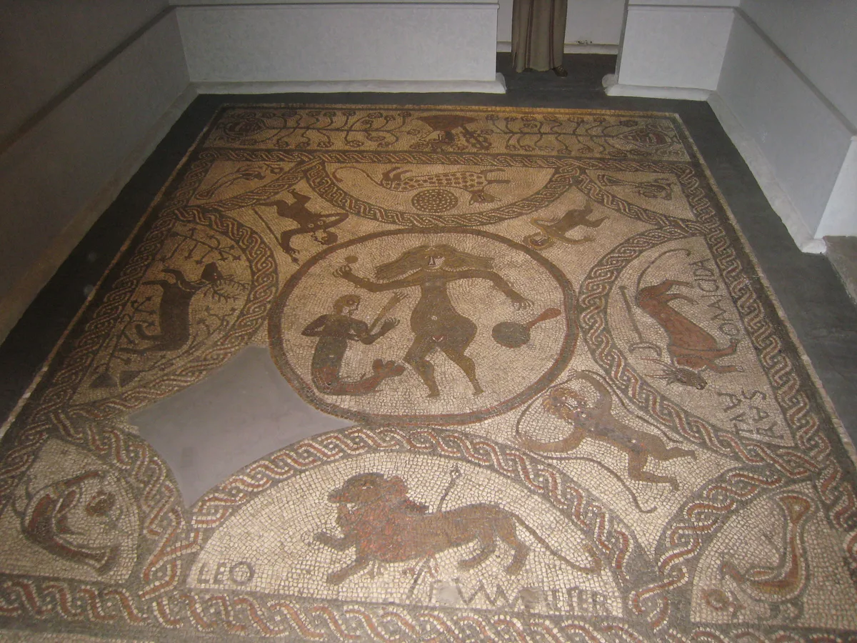
Rudston Roman villa
Rudston Roman villa — former Roman Villa in Rudston, East Riding of Yorkshire, England, UK.
📷 3Historic bridges · Yorkshire & the Humber
Bridge, Approximately 60 Metres South East Of Stable Block At Thorpe Hall
Bridge, Approximately 60 Metres South East Of Stable Block At Thorpe Hall — Grade II listed building-listed bridge in england-yorkshire, United Kingdom.
More towns in this region
 Flagship📷 4
Towns & cities · Yorkshire & the Humber
Bradford
Bradford — city and largest settlement in the City of Bradford district, Yorkshire, England.
 Flagship📷 5
Towns & cities · Yorkshire & the Humber
Coxwold
Coxwold — village and civil parish in North Yorkshire, England.
 Flagship📷 5
Towns & cities · Yorkshire & the Humber
Great Ayton
Great Ayton — village in North Yorkshire, England, UK.
May2005.jpg?width=1200) Flagship📷 5
Flagship📷 5Towns & cities · Yorkshire & the Humber
Great Langton
Great Langton — village in North Yorkshire, England, UK.
Frequently asked questions
- Where is Rudston?
- Rudston is in Yorkshire, United Kingdom (postcode YO25), in the parish of Rudston.
- Is Rudston free to visit?
- Yes, Rudston is free to enter.
- How do I get to Rudston?
- Drivers can navigate to postcode YO25. It sits within the Bridlington and The Wolds parliamentary constituency.