Mountains & hills · North Wales
Rhinog Fawr
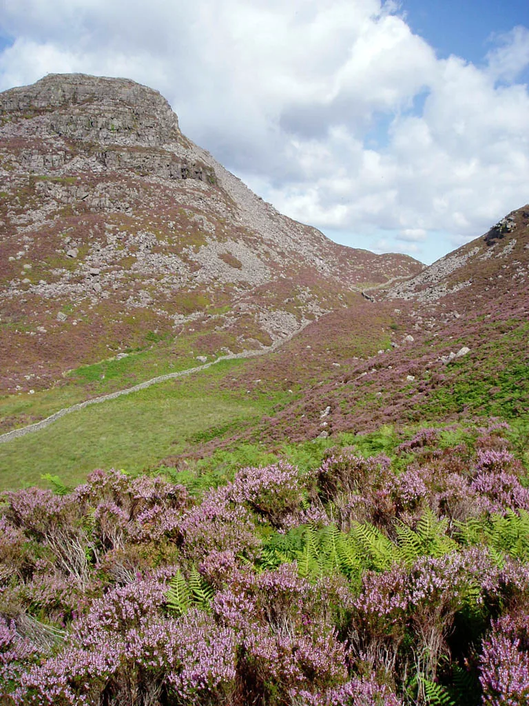
Rhinog Fawr — Named summit at 715 m.

Wikimedia Commons contributors — see linked file page for photographer and licence licence
Plan your visit
- Typical visit
- 3 h–8 h
- Best time of year
- Late spring – early autumn (May–Oct)
- Nearest railway station
- Pensarn · 7.9 km
- Free entry
- Dog-friendly
About
Rhinog Fawr is a named summit in the United Kingdom. Wikidata describes it as: "Named summit at 715 m.". Coordinates: 52.8419°, -3.9956°.
Photo gallery
From the Wikipedia article
Rhinog Fawr is a mountain in Snowdonia, North Wales and forms part of the Rhinogydd range. It is the third highest summit of the Rhinogydd, losing out to Y Llethr and Diffwys respectively. Its smaller cousin Rhinog Fach lies to the south, separated by the pass of Bwlch Drws Ardudwy, while its other neighbour, Moel Ysgyfarnogod lies to the north. In common with most of the range, the terrain is characterised by hard sedimentary rock covered with heather, making progress on foot difficult. At 510m, nestled in crags, lies Llyn Du, a small tarn beneath the summit. The ascent is most easily made from the north-east or north-west, via the Roman Steps pass.
Excerpt from Wikipedia under CC BY-SA 4.0. See the source article linked in Sources below.
- Coordinates
- 52.8419, -3.9956
- Address
- Gwynedd, Wales
- Nearest railway station
- Pensarn — 7.9 km
Sources
- osm: n29761763 (ODbL)
- wikipedia: Rhinog Fawr (CC BY-SA 4.0)
- commons: Rhinog Fawr.jpg (CC BY-SA 4.0)
Other places nearby
Loading nearby places…
Nearby
 📷 5
📷 5Natural landmarks · North Wales
Rhinog Fawr
Rhinog Fawr — mountain (720m) in Gwynedd.
 📷 3
📷 3Mountains & hills · North Wales
Craig Llyn Du (Rhinog Fawr)
Craig Llyn Du (Rhinog Fawr) — a mountain in wales-north, United Kingdom, 553 m.
 📷 3
📷 3Mountains & hills · North Wales
Moel Morwynion SW Top
Moel Morwynion SW Top — a mountain in wales-north, United Kingdom, 497 m.
 📷 3
📷 3Mountains & hills · North Wales
Moel Morwynion
Moel Morwynion — a mountain in wales-north, United Kingdom, 518 m.
 📷 3
📷 3Mountains & hills · North Wales
Carreg-y-Saeth
Carreg-y-Saeth — a mountain in wales-north, United Kingdom, 452 m.
 📷 3
📷 3Castles · North Wales
Castell Carreg-y-saeth
Castell Carreg-y-saeth — a castle in wales-north, United Kingdom.
More mountains in this region
 📷 5
📷 5Mountains & hills · North Wales
Cemlyn Bay and lagoon
Cemlyn Bay and lagoon — Site of Special Scientific Interest in Wales.
 📷 3
📷 3Mountains & hills · North Wales
Aberffraw Bay
Aberffraw Bay — bay on the west coast of Anglesey, in Wales, UK.
 📷 3
📷 3Mountains & hills · North Wales
Allt-fawr
Allt-fawr — Named summit at 698 m.
 📷 3
📷 3Mountains & hills · North Wales
Aran Benllyn
Aran Benllyn — Named summit at 884 m.
Frequently asked questions
- Where is Rhinog Fawr?
- Rhinog Fawr is in North Wales, United Kingdom.
- Is Rhinog Fawr free to visit?
- Yes, Rhinog Fawr is free to enter.
- How do I get to Rhinog Fawr?
- The nearest railway station is Pensarn, about 7.9 km away.