Mountains & hills · North Wales
Red Wharf Bay
Also known as: Traeth Coch
Red Wharf Bay is a mountain or hill in the United Kingdom.

Wikimedia Commons contributors — see linked file page for photographer and licence licence
Plan your visit
- Typical visit
- 3 h–8 h
- Best time of year
- Late spring – early autumn (May–Oct)
- Nearest railway station
- Llanfairpwll · 8.4 km
- Free entry
- Dog-friendly
About
Red Wharf Bay is a named summit in the United Kingdom. Coordinates: 53.2965°, -4.2071°. This entry is part of The Great Britain Guide, a free, ad-free, open-data tourist directory.
Photo gallery
From the Wikipedia article
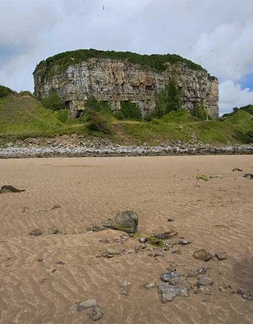
Red Wharf Bay, also known as Traeth Coch (Welsh for "red beach"), is a village and a sandy bay in Anglesey, Wales. The bay lies between the villages of Pentraeth and Benllech. It is also close to Castell Mawr Rock, thought to be the site of an Iron Age fort.
Excerpt from Wikipedia under CC BY-SA 4.0. See the source article linked in Sources below.
Background
History
The name of Traeth Coch is believed to originate from a battle involving Vikings in 1170 that left the beach soaked in blood. A hoard of five Scandinavian type arm-rings was discovered at Red Wharf Bay between c. 1887 and c. 1894. Historian Mark Redknap wrote that "The Red Wharf Bay arm-rings are probably contemporary with the Cuerdale Hoard (buried c. 905), and it's been suggested that Ingimund’s activities on Anglesey in 903 might have led to the deposition and their non-recovery." There was once a railway line which terminated at the bay, the Red Wharf Bay branch line, which left the Anglesey Central Railway at Pentre Berw. Stone for the Admiralty Arch, Holyhead was quarried near the bay.
Description
Red Wharf Bay is on the western side of the bay. It is linked to Benllech and Pentraeth via the Anglesey Coastal Path. Red Wharf Bay has three restaurants—The Tavern on the Bay, The Ship Inn, and The Boathouse.
Sourced from Wikipedia under CC BY-SA 4.0.
- Coordinates
- 53.2965, -4.2071
- District
- Isle of Anglesey
- Parish
- Pentraeth
- Postcode
- LL75 8PQ
- Parliamentary constituency
- Ynys Môn
- Nearest railway station
- Llanfairpwll — 8.4 km
Sources
- wikidata: Q3405755 (CC0)
- wikipedia: Red Wharf Bay (CC BY-SA 4.0)
- commons: Traeth-coch - geograph.org.uk - 73058.jpg (CC BY-SA 4.0)
Other places nearby
Loading nearby places…
Nearby
 📷 5
📷 5Historic bridges · North Wales
Bridge at Red Wharf Bay
Bridge at Red Wharf Bay — Grade II listed building-listed bridge in wales-north, United Kingdom.
Caravan parks · North Wales
Clai Mawr Holiday Park
Clai Mawr Holiday Park — a caravan park in wales north.
 📷 3
📷 3Mountains & hills · North Wales
Castell Mawr Rock
Castell Mawr Rock — Named summit at 25 m.
 📷 5
📷 5Historic churches · North Wales
Pentraeth
Pentraeth (Welsh: ['pɛntraiθ]) is a village and community on the island of Anglesey (Ynys Môn), North Wales, at grid reference SH523786. The Royal Mail postcode begins LL75. The community population t
Caravan parks · North Wales
Rhos Caravan Park
Rhos Caravan Park — a caravan park in wales north.
 📷 3
📷 3Beaches · North Wales
Benllech Sands
Benllech Sands is a beach in the United Kingdom.
More mountains in this region
 📷 5
📷 5Mountains & hills · North Wales
Cemlyn Bay and lagoon
Cemlyn Bay and lagoon — Site of Special Scientific Interest in Wales.
 📷 3
📷 3Mountains & hills · North Wales
Aberffraw Bay
Aberffraw Bay — bay on the west coast of Anglesey, in Wales, UK.
 📷 3
📷 3Mountains & hills · North Wales
Allt-fawr
Allt-fawr — Named summit at 698 m.
 📷 3
📷 3Mountains & hills · North Wales
Aran Benllyn
Aran Benllyn — Named summit at 884 m.
Frequently asked questions
- Where is Red Wharf Bay?
- Red Wharf Bay is in North Wales, United Kingdom (postcode LL75 8PQ), in the parish of Pentraeth.
- Is Red Wharf Bay free to visit?
- Yes, Red Wharf Bay is free to enter.
- How do I get to Red Wharf Bay?
- Drivers can navigate to postcode LL75 8PQ. It sits within the Ynys Môn parliamentary constituency.