Towns & cities · Central Scotland
Ratho
Also known as: Ràthach
Ratho — village in City of Edinburgh, Scotland, UK.

Wikimedia Commons contributors — see linked file page for photographer and licence licence
Plan your visit
- Typical visit
- 3 h–6 h
- Nearest railway station
- Edinburgh Gateway · 4.3 km
- Free entry
- Family-friendly
- Dog-friendly
About
Ratho is a town, city, village or settlement in the United Kingdom. Recent population estimates put it at around 1,950 people. Wikidata describes it as: "village in City of Edinburgh, Scotland, UK". Coordinates: 55.9217°, -3.3803°.
Photo gallery
From the Wikipedia article
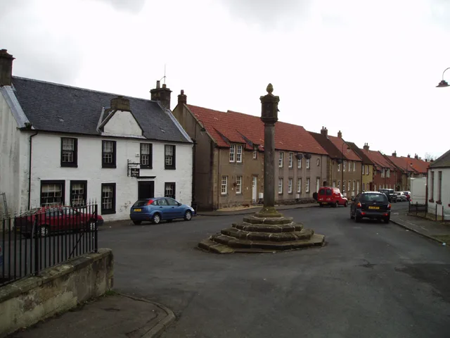
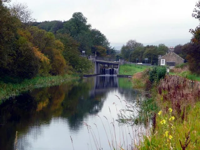
Ratho (Scottish Gaelic: Ràthach) is a village in the rural west part of the City of Edinburgh council area, Scotland. Its population at the 2011 census was 1,634 based on the 2010 definition of the locality. It was formerly in the old county of Midlothian. Ratho Station, Newbridge and Kirkliston are other villages in the area. The Union Canal passes through Ratho. Edinburgh Airport is situated only 4 miles (7 km) away. The village has a high ratio of its older houses built from whin stone due to a whin quarry nearby. The older, historical, part of the village was designated a Conservation Area.
Excerpt from Wikipedia under CC BY-SA 4.0. See the source article linked in Sources below.
Background
History
Ratho appears in written records from 1243 with various spellings such as Rath (ewe, eu, ew, ow, au) but most consistently, from 1292, with its present name Ratho. Other places nearby having "Ratho" in their names include Ratho Byres, Ratho Park and Ratho Bank (now named Ashley). It is believed that the name Ratho comes from Rath, Scottish Gaelic, for a place where there are hill forts. Both Kaimes and Dalmahoy hill forts are nearby. To the southwest of the village, Tormain Hill is the site of Stone Age symbols carved into the rocks atop the hill and a 'witches' stone'. When the witches' stone was moved by the land owner for farming, it was believed evil spirits were released into the…
Sourced from Wikipedia under CC BY-SA 4.0.
- Coordinates
- 55.9217, -3.3803
- District
- City of Edinburgh
- Postcode
- EH28 8RD
- Parliamentary constituency
- Edinburgh West
- Population
- 1,950
- Nearest railway station
- Edinburgh Gateway — 4.3 km
- Official site
- www.bcomm-scotland.independent.gov.uk
Sources
- wikidata: Q1011133 (CC0)
- wikipedia: Ratho (CC BY-SA 4.0)
- commons: Ratho kirk.JPG (CC BY-SA 4.0)
Other places nearby
Loading nearby places…
Nearby
Hotels · Central Scotland
The Bridge Inn
The Bridge Inn — a hotel in scotland central.
 📷 5
📷 5Historic bridges · Central Scotland
Bridge No. 15, Baird Road, Ratho, Union Canal
Bridge No. 15, Baird Road, Ratho, Union Canal — category B listed building-listed bridge in scotland-central, United Kingdom.
 📷 3
📷 3Historic bridges · Central Scotland
Rusack's Bridge
Rusack's Bridge is a historic bridge in the United Kingdom.
 📷 5
📷 5Memorials & monuments · Central Scotland
War Memorial, Baird Road, Ratho
War Memorial, Baird Road, Ratho — category B listed building-listed memorial in scotland-central, United Kingdom.
📷 5Historic churches · Central Scotland
Ratho Parish Church and Lady's Well, Baird Road, Ratho
Ratho Parish Church and Lady's Well, Baird Road, Ratho — category A listed building-listed church in scotland-central, United Kingdom.
📷 3Public art & sculpture · Central Scotland
Navvie
Navvie — a public art in scotland-central, United Kingdom.
More towns in this region
 Flagship📷 3
Towns & cities · Central Scotland
Airth
Airth — village in Falkirk, Scotland, UK.
 Flagship📷 5
Towns & cities · Central Scotland
Avonbridge
Avonbridge — village in Falkirk, Scotland, UK.
 Flagship📷 3
Towns & cities · Central Scotland
Banknock
Banknock — village in Falkirk, Scotland, UK.
 Flagship📷 3
Towns & cities · Central Scotland
Dundee
Dundee — city in Scotland, UK.
Frequently asked questions
- Where is Ratho?
- Ratho is in central Scotland, United Kingdom (postcode EH28 8RD).
- Is Ratho free to visit?
- Yes, Ratho is free to enter.
- How do I get to Ratho?
- The nearest railway station is Edinburgh Gateway, about 4.3 km away. Drivers can navigate to postcode EH28 8RD.