Canals · West Midlands
Peak Forest Canal
Also known as: Camlas Peak Forest
Peak Forest Canal — canal in Derbyshire/Cheshire/Greater Manchester, England, UK.

Wikimedia Commons contributors — see linked file page for photographer and licence licence
Plan your visit
- Typical visit
- 1 h–2 h
- Nearest railway station
- Disley · 1.1 km
- Free entry
- Dog-friendly
About
Peak Forest Canal is a canal in the United Kingdom. Wikidata describes it as: "canal in Derbyshire/Cheshire/Greater Manchester, England, UK". Coordinates: 53.3660°, -2.0540°.
Photo gallery
From the Wikipedia article
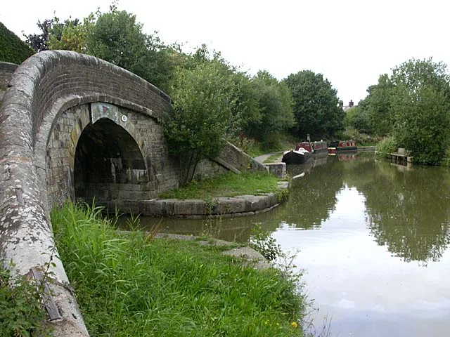
The Peak Forest Canal is a narrow (7-foot (2.13 m) gauge) locked artificial waterway in northern England. It is 14.8 miles (23.8 km) long and forms part of the connected English/Welsh inland waterway network.
Excerpt from Wikipedia under CC BY-SA 4.0. See the source article linked in Sources below.
Background
Architecture
The construction of the canal and tramway was promoted by Samuel Oldknow (the largest shareholder) with much of the finance being provided by Richard Arkwright Junior of Cromford, Derbyshire. The line was surveyed by Thomas Brown and the consulting engineer and resident engineer were Benjamin Outram and Thomas Brown, respectively. Work was begun first on the section between Ashton and Hyde Hall, where new coal-pits were being opened, so as to derive some income as soon as possible. Outram was somewhat delayed by a request from the committee to report on ideas by Robert Fulton who had been awarded the contract for the cuttings at Werneth. These would have replaced the stone construction of…
Sourced from Wikipedia under CC BY-SA 4.0.
- Coordinates
- 53.3660, -2.0540
- District
- Stockport
- Parish
- Stockport, unparished area
- Postcode
- SK6 8HB
- Parliamentary constituency
- Hazel Grove
- Established
- 1805
- Nearest railway station
- Disley — 1.1 km
Sources
- wikidata: Q7157817 (CC0)
- wikipedia: Peak Forest Canal (CC BY-SA 4.0)
- commons: Bugsworth 058079.jpg (CC BY-SA 4.0)
Other places nearby
Loading nearby places…
Nearby
 📷 3
📷 3Historic houses · West Midlands
Wyberslegh Hall
Wyberslegh Hall — Grade II listed house in High Lane, Stockport, Greater Manchester, England, UK.
 📷 3
📷 3Historic bridges · West Midlands
Canal Bridge, Number 23 By Little Woodend
Canal Bridge, Number 23 By Little Woodend — Grade II listed building-listed bridge in england-west-midlands, United Kingdom.
 📷 3
📷 3Memorials & monuments · West Midlands
Tower In Garden Of Woodbank House
Tower In Garden Of Woodbank House — Grade II listed building-listed memorial in england-west-midlands, United Kingdom.
 Flagship📷 3
Towns & cities · West Midlands
High Lane
High Lane — village in the Metropolitan Borough of Stockport, Greater Manchester, United Kingdom.
 📷 3
📷 3Memorials & monuments · West Midlands
High Lane War Memorial
High Lane War Memorial — Grade II listed building-listed memorial in england-west-midlands, United Kingdom.
 📷 3
📷 3Historic bridges · West Midlands
Bridge over Bollinhurst Brook 30 metres north of Brookside Farmhouse
Bridge over Bollinhurst Brook 30 metres north of Brookside Farmhouse — Grade II listed building-listed bridge in england-west-midlands, United Kingdom.
More places in this region
 📷 3
📷 3Canals · West Midlands
Anson Branch
Anson Branch — canal in West Midlands, England.
 📷 3
📷 3Canals · West Midlands
Ashton Canal
Ashton Canal — canal in north west England.
 📷 3
📷 3Canals · West Midlands
Aylesbury Canal Arm
Aylesbury Canal Arm — canal in the United Kingdom.
 📷 4
📷 4Canals · West Midlands
BCN Main Line
BCN Main Line — Canal in and around Birmingham , England.
Frequently asked questions
- Where is Peak Forest Canal?
- Peak Forest Canal is in the West Midlands, United Kingdom (postcode SK6 8HB), in the parish of Stockport, unparished area.
- When was Peak Forest Canal built?
- Built or established in 1805.
- Is Peak Forest Canal free to visit?
- Yes, Peak Forest Canal is free to enter.
- How do I get to Peak Forest Canal?
- The nearest railway station is Disley, about 1.1 km away. Drivers can navigate to postcode SK6 8HB.