Canal locks · West Midlands
Osney Lock
Osney Lock — lock on the River Thames in Oxfordshire, England.

Wikimedia Commons contributors — see linked file page for photographer and licence licence
Plan your visit
- Typical visit
- 20 min–45 min
- Nearest railway station
- Oxford · 0.5 km
- Free entry
- Dog-friendly
About
Osney Lock is a canal lock in the United Kingdom. Wikidata describes it as: "lock on the River Thames in Oxfordshire, England". Coordinates: 51.7486°, -1.2713°.
Photo gallery
From the Wikipedia article
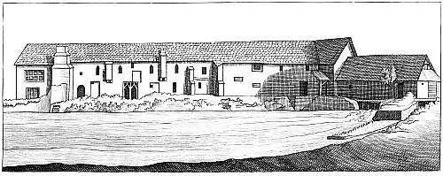
Osney Lock is a lock on the River Thames in Oxford, England, where the village or island of Osney is next to the river. The first lock was built of stone by Daniel Harris for the Thames Navigation Commission in 1790. Across the weir pool is a large Environment Agency complex which monitors the River Thames, while a small office building exists on the front lawn opposite the lock house. The weir is upstream of the lock alongside the navigation channel in two parts and feeds the Osney pool. The Osney Lock Hydro hydro-electric plant occupies a building beside the weir. To the south and southwest are Osney Mill Marina and Osney Cemetery. Oxford railway station on the Botley Road is close by to the northwest.
Excerpt from Wikipedia under CC BY-SA 4.0. See the source article linked in Sources below.
Background
History
The main navigation channel was formerly on the branch of the river known as Bulstake Stream further west. The present stream was developed in mediaeval times by the monks of Osney Abbey on the west side of the island then known as Osney, to serve as a millstream for Osney Mill, in a manner similar to that at Abingdon. There was an ancient weir, the property of the Abbey on the site, and a pound lock was first considered in 1787. The stream became the main navigation channel when the lock was built in 1790. Daniel Harris used prisoner labour from Oxford jail to give the cheapest quote for the work. The last rebuilding of the lock was in 1905.
Visiting
The lock can be reached a short way down the towpath from Osney Bridge on the A420 Botley Road on the way west out of the centre of Oxford.
Sourced from Wikipedia under CC BY-SA 4.0.
- Coordinates
- 51.7486, -1.2713
- County
- Oxfordshire
- District
- Oxford
- Parish
- Oxford, unparished area
- Postcode
- OX2 0HJ
- Parliamentary constituency
- Oxford West and Abingdon
- Nearest railway station
- Oxford — 0.5 km
- Official site
- www.environment-agency.gov.uk
Sources
- wikidata: Q7107288 (CC0)
- wikipedia: Osney Lock (CC BY-SA 4.0)
- commons: OsneyLock.jpg (CC BY-SA 4.0)
Other places nearby
Loading nearby places…
Nearby
 📷 3
📷 3Cathedrals · West Midlands
Osney Abbey
Osney Abbey — house of Augustinian canons at Osney in Oxfordshire, England, UK.
 📷 3
📷 3Mills · West Midlands
Osney Mill
Osney Mill — flour mill in Oxford, UK.
 📷 3
📷 3Memorials & monuments · West Midlands
The First Superconducting Magnet for MRI Scanning
The First Superconducting Magnet for MRI Scanning — a memorial in england-west-midlands, United Kingdom.
 📷 3
📷 3Cemeteries · West Midlands
Osney Cemetery
Osney Cemetery is a cemetery in the United Kingdom.
 📷 3
📷 3Memorials & monuments · West Midlands
Edgar George Wilson
Edgar George Wilson — a memorial in england-west-midlands, United Kingdom.
 📷 3
📷 3Historic bridges · West Midlands
Osney Rail Bridge
Osney Rail Bridge is a historic bridge in the United Kingdom.
More places in this region
 📷 3
📷 3Canal locks · West Midlands
Abingdon Lock
Abingdon Lock — lock on the River Thames in England.
 📷 3
📷 3Canal locks · West Midlands
Baddiley Lock Number 1
Baddiley Lock Number 1 — Grade II listed building in Baddiley, Cheshire, England, UK.
 📷 3
📷 3Canal locks · West Midlands
Baddiley Lock Number 2
Baddiley Lock Number 2 — Grade II listed building in Baddiley, Cheshire, England, UK.
 📷 3
📷 3Canal locks · West Midlands
Baddiley Lock Number 3
Baddiley Lock Number 3 — Grade II listed building in Baddiley, Cheshire, England, UK.
Frequently asked questions
- Where is Osney Lock?
- Osney Lock is in West Midlands, in the United Kingdom — coordinates 51.7486°, -1.2713°. The nearest railway station is Oxford, around 0.5 km away.
- Is Osney Lock free to visit?
- Yes — admission to Osney Lock is free.