Mountains & hills · West Midlands
North Hill
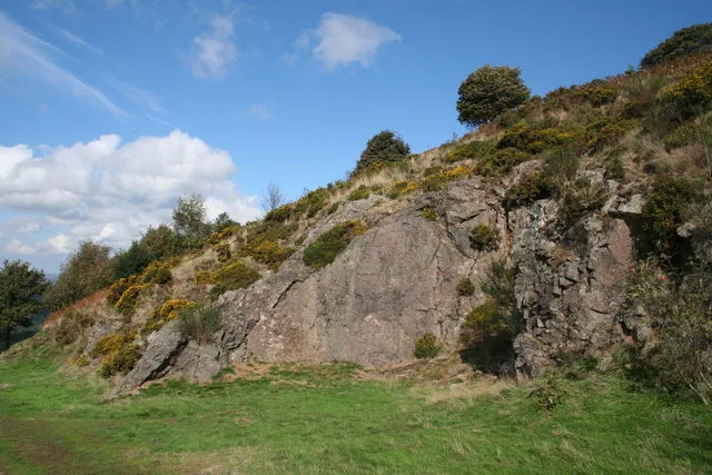
North Hill — Named summit at 398 m.

Wikimedia Commons contributors — see linked file page for photographer and licence licence
Plan your visit
- Typical visit
- 3 h–8 h
- Best time of year
- Late spring – early autumn (May–Oct)
- Nearest railway station
- Great Malvern · 1.5 km
- Free entry
- Dog-friendly
About
North Hill is a named summit in the United Kingdom. Wikidata describes it as: "Named summit at 398 m.". Coordinates: 52.1151°, -2.3383°.
Photo gallery
Protected designations
- Site of Special Scientific Interest: The Malvern Hills SSSI
- Area of Outstanding Natural Beauty: Cotswolds
- Area of Outstanding Natural Beauty: Malvern Hills
Designations sourced from Natural England open data under OGL v3.
From the Wikipedia article
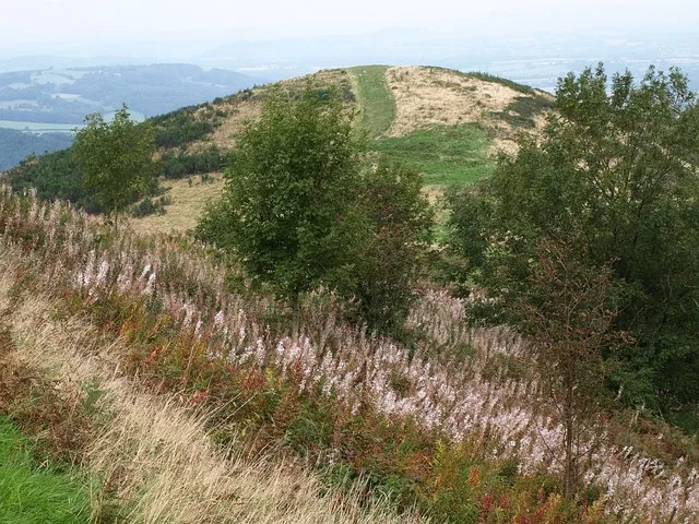
North Hill is the second highest point of the range of Malvern Hills that runs about 13 kilometres (8.1 mi) north-south along the Herefordshire-Worcestershire border, although North Hill lies entirely within Worcestershire. It has an elevation of 397 metres (1,302 ft), making it the highest point of the Worcestershire Way. The eastern flank of the hill lies directly behind Worcester road in Great Malvern from where its summit is a brisk 15 – 20 minutes steep walk from the town centre via St Ann's road and Happy Valley. A path from the car park in North Malvern follows the lower contour of North Hill to Happy Valley and St. Ann's Well.
Excerpt from Wikipedia under CC BY-SA 4.0. See the source article linked in Sources below.
Background
History
Although the flint route from North Wales to Wessex lay to the north of Malvern, there is some evidence to suggest that traders passed over the Malvern Hills. Parts of an arrowhead, scraper and flint flakes have been discovered between the North Hill and Table Hill. A 19th-century guide book describes both a collapsed burial mound on North Hill named the Giant's Grave and a tump on Table Hill. These tumuli may have been connected to the Dobunni settlement in Mathon. A track that runs along North Hill was known as the "Pyx Path" and was used by the priest from Worcestershire when bringing Sacrament to the hermits that lived in Malvern in the 11th Century. It was also referred to as the…
Description
When launched back in 1989 the Worcestershire Way was 48 mi long and ran partly into Herefordshire. The route and its length were modified in 2004 and it now runs wholly within Worcestershire. The last few miles of the Way now ascend to the northern part of the Malvern Hills and skirt around the contours of End Hill, Table Hill and along Lady Howard de Walden's Drive on North Hill, before descending to Great Malvern via St Ann's Well.
Sourced from Wikipedia under CC BY-SA 4.0.
- Coordinates
- 52.1151, -2.3383
- County
- Worcestershire
- District
- Malvern Hills
- Parish
- West Malvern
- Postcode
- WR14 4BN
- Parliamentary constituency
- West Worcestershire
- Nearest railway station
- Great Malvern — 1.5 km
- Official site
- web.archive.org
Sources
- osm: n469956079 (ODbL)
- wikipedia: North Hill, Malvern (CC BY-SA 4.0)
- commons: Belle Vue Terrace, Malvern from the top of Priory Church - geograph.org.uk - 3493.jpg (CC BY-SA 4.0)
Other places nearby
Loading nearby places…
Nearby
Mountain bike trails · West Midlands
Malvern Hills Short Mountain Bike Trail
Malvern Hills Short Mountain Bike Trail — a mtb trail in england west midlands.
 📷 3
📷 3Mountains & hills · West Midlands
Table Hill
Table Hill — Named summit at 375 m.
 📷 3
📷 3Mountains & hills · West Midlands
End Hill
End Hill — Named summit at 328 m.
 📷 3
📷 3Towns & cities · West Midlands
West Malvern
West Malvern — village in Worcestershire, England, UK.
 📷 3
📷 3Memorials & monuments · West Midlands
The Promenade
The Promenade — a memorial in england-west-midlands, United Kingdom.
📷 5Historic churches · West Midlands
Bright Earth
Bright Earth — a church in england-west-midlands, United Kingdom.
More mountains in this region
 📷 5
📷 5Mountains & hills · West Midlands
Arbury Hill
Arbury Hill — Named summit at 224.3 m.
Mountains & hills · West Midlands
Barr Beacon
Barr Beacon — Named summit at 227 m.
 📷 3
📷 3Mountains & hills · West Midlands
Barrow Hill
Barrow Hill — Named summit at 179 m.
Mountains & hills · West Midlands
Beacon Hill
Beacon Hill — Named summit at 237 m.
Frequently asked questions
- Where is North Hill?
- North Hill is in Worcestershire, the West Midlands, United Kingdom (postcode WR14 4BN), in the parish of West Malvern.
- Is North Hill a protected site?
- Yes — North Hill is part of the The Malvern Hills SSSI Site of Special Scientific Interest and the Cotswolds National Landscape (AONB).
- Is North Hill free to visit?
- Yes, North Hill is free to enter.
- How do I get to North Hill?
- The nearest railway station is Great Malvern, about 1.5 km away. Drivers can navigate to postcode WR14 4BN.