Mountains & hills · North Wales
Mynydd Drws-Y-Coed
Mynydd Drws-Y-Coed — Named summit at 695 m.

Wikimedia Commons contributors — see linked file page for photographer and licence licence
Plan your visit
- Typical visit
- 3 h–8 h
- Best time of year
- Late spring – early autumn (May–Oct)
- Nearest railway station
- Rhyd Ddu · 2.3 km
- Free entry
- Dog-friendly
About
Mynydd Drws-Y-Coed is a named summit in the United Kingdom. Wikidata describes it as: "Named summit at 695 m.". Coordinates: 53.0439°, -4.1660°.
Photo gallery
From the Wikipedia article
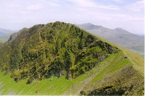
Mynydd Drws-y-Coed is a peak on the Nantlle Ridge in Snowdonia, north Wales. It is located at the easterly end of the ridge, and is a subsidiary summit of Trum y Ddysgl. It has steep west-facing cliffs, the summit area being the highest point on a thin ridge. The west side is very rocky and airy, and some scrambling is needed to attain the summit. A good head for heights will also be needed on the exposed regions.
Excerpt from Wikipedia under CC BY-SA 4.0. See the source article linked in Sources below.
- Coordinates
- 53.0439, -4.1660
- Address
- Gwynedd, Wales
- Nearest railway station
- Rhyd Ddu — 2.3 km
Sources
- osm: n10082755670 (ODbL)
- wikipedia: Mynydd Drws-y-Coed (CC BY-SA 4.0)
- commons: Drwsycoed.jpg (CC BY-SA 4.0)
Other places nearby
Loading nearby places…
Nearby
 📷 3
📷 3Natural landmarks · North Wales
Mynydd Drws-y-Coed
Mynydd Drws-y-Coed — mountain (695m) in Gwynedd.
 📷 3
📷 3Mountains & hills · North Wales
Trum Y Ddysgl
Trum Y Ddysgl — Named summit at 709 m.
 📷 3
📷 3Natural landmarks · North Wales
Trum y Ddysgl
Trum y Ddysgl — mountain (709m) in Gwynedd.
 📷 3
📷 3Mountains & hills · North Wales
Y Garn
Y Garn — Named summit at 633 m.
 📷 3
📷 3Mountains & hills · North Wales
Mynydd Tal-y-Mignedd
Mynydd Tal-y-Mignedd — Named summit at 653 m.
 📷 3
📷 3Memorials & monuments · North Wales
Victoria Jubilee monument
Victoria Jubilee monument is a memorial in the United Kingdom.
More mountains in this region
 📷 5
📷 5Mountains & hills · North Wales
Cemlyn Bay and lagoon
Cemlyn Bay and lagoon — Site of Special Scientific Interest in Wales.
 📷 3
📷 3Mountains & hills · North Wales
Aberffraw Bay
Aberffraw Bay — bay on the west coast of Anglesey, in Wales, UK.
 📷 3
📷 3Mountains & hills · North Wales
Allt-fawr
Allt-fawr — Named summit at 698 m.
 📷 3
📷 3Mountains & hills · North Wales
Aran Benllyn
Aran Benllyn — Named summit at 884 m.
Frequently asked questions
- Where is Mynydd Drws-Y-Coed?
- Mynydd Drws-Y-Coed is in North Wales, United Kingdom.
- Is Mynydd Drws-Y-Coed free to visit?
- Yes, Mynydd Drws-Y-Coed is free to enter.
- How do I get to Mynydd Drws-Y-Coed?
- The nearest railway station is Rhyd Ddu, about 2.3 km away.