Mountains & hills · North Wales
Moel y Parc
Moel y Parc — Named summit at 395 m.

Wikimedia Commons contributors — see linked file page for photographer and licence licence
_45.png)
Plan your visit
- Typical visit
- 3 h–8 h
- Best time of year
- Late spring – early autumn (May–Oct)
- Free entry
- Dog-friendly
About
Moel y Parc is a named summit in the United Kingdom. Wikidata describes it as: "Named summit at 395 m.". Coordinates: 53.2198°, -3.3204°.
Photo gallery
From the Wikipedia article
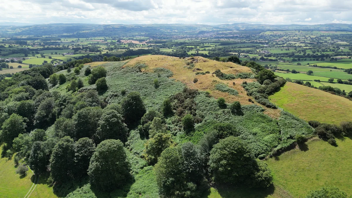
Moel y Parc (sometimes written as Moel-y-Parc) is a hill on the border between Denbighshire and Flintshire in Wales. It is one of the Clwydian Hills, rising 398 metres (1,306 ft) above sea level and is located at OS grid reference SJ114703. There is a television mast near the summit. The summit marks the boundary of Aberwheeler and Ysceifiog communities, and is the site of a cairn and tumulus.
Excerpt from Wikipedia under CC BY-SA 4.0. See the source article linked in Sources below.
- Coordinates
- 53.2198, -3.3204
- District
- Denbighshire
- Parish
- Aberwheeler
- Postcode
- LL16 4HS
- Parliamentary constituency
- Clwyd East
Sources
- osm: n2819450747 (ODbL)
- wikipedia: Moel y Parc (CC BY-SA 4.0)
- commons: Moel y Parc - un o fryniau Clwyd - one of the Clwydian Hills, Denbighshire and Flintshire, Cymru (Wales) 45.png (CC BY-SA 4.0)
Other places nearby
Loading nearby places…
Nearby
 📷 3
📷 3Natural landmarks · North Wales
Afonwen Craft and Antique Centre
Afonwen Craft and Antique Centre — a other in wales-north, United Kingdom.
 📷 5
📷 5Mountains & hills · North Wales
Penycloddiau
Penycloddiau — Named summit at 440 m.

Mountains & hills · North Wales
Bryn Golau
Bryn Golau — a mountain in wales-north, United Kingdom, 302 m.
 📷 3
📷 3Hill forts · North Wales
Moel y Gaer, Bodfari
Moel y Gaer, Bodfari — hillfort in Denbighshire, Wales.
 📷 3
📷 3Hill forts · North Wales
Moel-y-Gaer Hill Fort
Moel-y-Gaer Hill Fort — a hill fort in wales-north, United Kingdom.
 📷 5
📷 5Hill forts · North Wales
Penycloddiau
Penycloddiau — hillfort primarily located in Ysceifiog community, Flintshire.
More mountains in this region
 📷 5
📷 5Mountains & hills · North Wales
Cemlyn Bay and lagoon
Cemlyn Bay and lagoon — Site of Special Scientific Interest in Wales.
 📷 3
📷 3Mountains & hills · North Wales
Aberffraw Bay
Aberffraw Bay — bay on the west coast of Anglesey, in Wales, UK.
 📷 3
📷 3Mountains & hills · North Wales
Allt-fawr
Allt-fawr — Named summit at 698 m.
 📷 3
📷 3Mountains & hills · North Wales
Aran Benllyn
Aran Benllyn — Named summit at 884 m.
Frequently asked questions
- Where is Moel y Parc?
- Moel y Parc is in North Wales, United Kingdom (postcode LL16 4HS), in the parish of Aberwheeler.
- Is Moel y Parc free to visit?
- Yes, Moel y Parc is free to enter.
- How do I get to Moel y Parc?
- Drivers can navigate to postcode LL16 4HS. It sits within the Clwyd East parliamentary constituency.