Mountains & hills · North West England
Lambrigg Fell
Lambrigg Fell — Named summit at 339 m.

Wikimedia Commons contributors — see linked file page for photographer and licence licence
Plan your visit
- Typical visit
- 3 h–8 h
- Best time of year
- Late spring – early autumn (May–Oct)
- Nearest railway station
- Kendal · 6.7 km
- Free entry
- Dog-friendly
About
Lambrigg Fell is a named summit in the United Kingdom. Wikidata describes it as: "Named summit at 339 m.". Coordinates: 54.3411°, -2.6382°.
Photo gallery
From the Wikipedia article
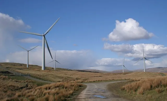
Lambrigg Fell is a hill, the highest point of the area of high ground between Kendal and the M6, in south-eastern Cumbria, England. It lies just outside the area normally defined as the Lake District, and the hill is not in the same mould as the nearby Lakeland Fells, being a sprawling, grassy moorland. For this reason, it is not nearly as popular as its subsidiary top to the west, Benson Knott, which overlooks Kendal. However, the hill provides close-range views of both the Howgill Fells and the Lake District, together with the Yorkshire Dales. The hill can be accessed by the minor road linking Docker and Lambrigg Head, which runs across the northern slopes of the fell. However, car parking is very limited near to the access gate. A track runs most of the way towards the summit, passing a small reservoir. The landowner is strongly opposed to use of this track from the top sheepfold onwards and the right of way follows a due south route over boggy ground from the top sheepfold. This gives a walk of about two and a half miles. Note that the right of way does not reach the summit and the landowner has acted to prevent those making the 200metre diversion to get to the top. Some 100 metres west of the summit, on the eastern side of the bridleway, the ruins of a small building may be seen. The exact nature of this structure is unclear, but local residents state that it was used as a shelter for members of shooting parties on the fell. It is possible to continue in a southerly direction along the bridleway and complete the walk by joining the A684, Sedbergh Road. There is a large wind farm owned by Innogy just to the east of the summit. The wind farm, which can generate 6.5 Megawatts of electricity, was opened in September 2000 and at that time it was the largest wind farm to be built in England since 1993. The land on which the wind farm is built is out of bounds to unauthorized personnel. The block of land of which Lambrigg Fell is the summit — thus making it a Marilyn…
Excerpt from Wikipedia under CC BY-SA 4.0. See the source article linked in Sources below.
- Coordinates
- 54.3411, -2.6382
- District
- Westmorland and Furness
- Parish
- New Hutton
- Postcode
- LA8 0AY
- Parliamentary constituency
- Westmorland and Lonsdale
- Nearest railway station
- Kendal — 6.7 km
Sources
- osm: n2137731691 (ODbL)
- wikipedia: Lambrigg Fell (CC BY-SA 4.0)
- commons: Lambrigg wind farm.jpg (CC BY-SA 4.0)
Featured in this guide
Other places nearby
Loading nearby places…
Nearby
 📷 3
📷 3Natural landmarks · North West England
Lambrigg Fell
Lambrigg Fell — 339m high mountain in England.
 📷 2
📷 2Natural landmarks · North West England
Firbank Fell
Firbank Fell — 324m high mountain in England.
 📷 3
📷 3Historic bridges · North West England
Docker Viaduct
Docker Viaduct is a historic bridge in the United Kingdom.
 📷 3
📷 3Towns & cities · North West England
Grayrigg
Grayrigg — a village located in South Lakeland, United Kingdom.
 📷 3
📷 3Reservoirs & lochs · North West England
Killington Reservoir
Killington Reservoir — reservoir in Cumbria, England, UK.
 📷 3
📷 3Memorials & monuments · North West England
Fox's Pulpit
Fox's Pulpit — a memorial in england-north-west, United Kingdom.
More mountains in this region
 📷 3
📷 3Mountains & hills · North West England
Allen Crags
Allen Crags — Named summit at 785 m.
 📷 3
📷 3Mountains & hills · North West England
Alum Pot
Alum Pot — Open shaft pothole in North Yorkshire.
 📷 3
📷 3Mountains & hills · North West England
Arnside Knott
Arnside Knott — Named summit at 159 m.
 📷 3
📷 3Mountains & hills · North West England
Aye Gill Pike
Aye Gill Pike — Named summit at 556.3 m.
Frequently asked questions
- Where is Lambrigg Fell?
- Lambrigg Fell is in North-West England, United Kingdom (postcode LA8 0AY), in the parish of New Hutton.
- Is Lambrigg Fell free to visit?
- Yes, Lambrigg Fell is free to enter.
- How do I get to Lambrigg Fell?
- The nearest railway station is Kendal, about 6.7 km away. Drivers can navigate to postcode LA8 0AY.