Towns & cities · Yorkshire & the Humber
Kirk Deighton
Kirk Deighton — village in North Yorkshire, England, UK.

Wikimedia Commons contributors — see linked file page for photographer and licence licence
Plan your visit
- Typical visit
- 3 h–6 h
- Nearest railway station
- Cattal · 7.3 km
- Free entry
- Family-friendly
- Dog-friendly
About
Kirk Deighton is a town, city, village or settlement in the United Kingdom. Recent population estimates put it at around 386 people. Address: LS22. Wikidata describes it as: "village in North Yorkshire, England, UK". Coordinates: 53.9478°, -1.3939°.
Photo gallery
From the Wikipedia article
Kirk Deighton is a village and civil parish in the county of North Yorkshire, England. It is situated north-west of Wetherby and near the A1(M) motorway. The village was in the West Riding of Yorkshire, and Wetherby Rural District, until 1974, and is now 0.5 mile north of the border between West Yorkshire and North Yorkshire. The civil parish extends east of the A1(M) and north to the River Nidd. It includes the hamlet of Ingmanthorpe, and Wetherby Services on the motorway. The civil parish had a population of 484 in the 2011 Census.
Excerpt from Wikipedia under CC BY-SA 4.0. See the source article linked in Sources below.
Background
History
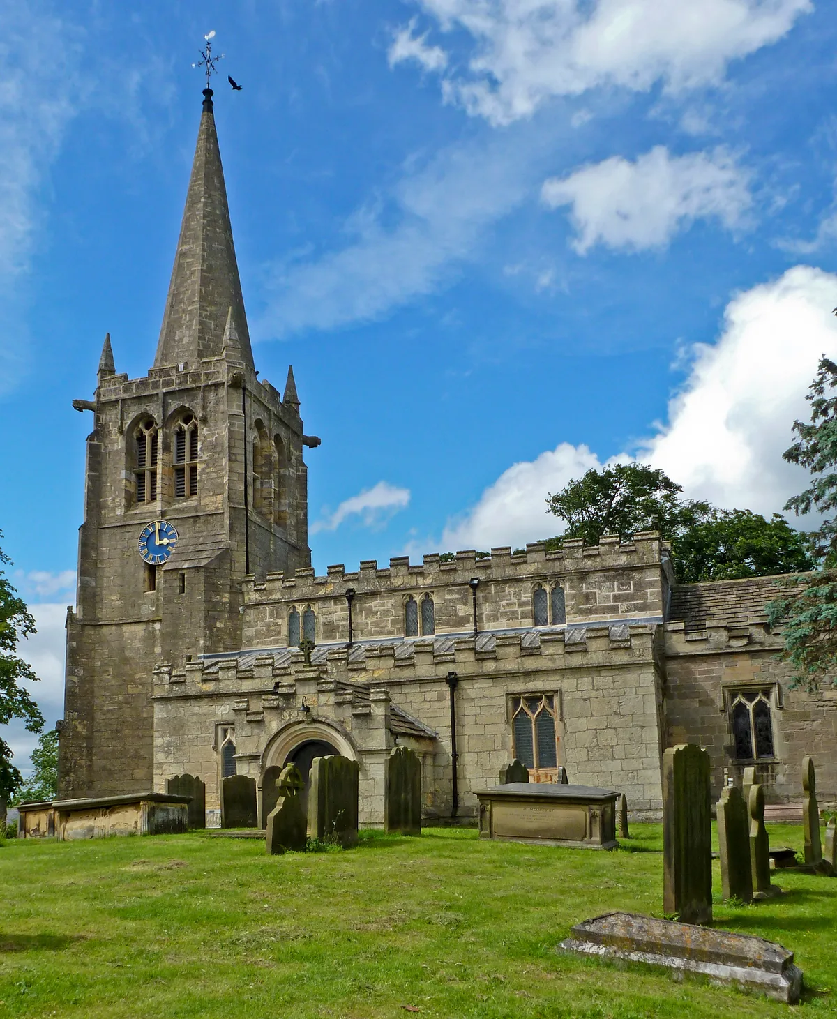
Kirk Deighton and its church (All Saints' Church) were mentioned in the Domesday Book. The name of the village derives from Kirk (meaning church) and Dĩc-tūn; a town surrounded by a moat or ditch. At the 2001 Census, the population of the village was 386, which by the 2011 Census had risen to 484. Historically, the village and parish were in the Wetherby Rural District and the Wapentake of Claro. In 1974, the village was moved into North Yorkshire (from the West Riding of Yorkshire). From 1974 to 2023 it was part of the Borough of Harrogate, it is now administered by the unitary North Yorkshire Council.
Architecture
]] The most architecturally notable building in the village is All Saints' Church, the main structure of which dates between the 12th and 14th century. Kirk Deighton Hall is a late 18th century private residence situated off Mark Lane and is Grade II listed. Main Street has a mixture of buildings dating from the 16th to the 19th century. There are some twentieth century council houses on Wetherby Road as well as some twentieth century private houses on Ashdale Lane.
Sourced from Wikipedia under CC BY-SA 4.0.
- Coordinates
- 53.9478, -1.3939
- District
- North Yorkshire
- Parish
- Kirk Deighton
- Postcode
- LS22
- Parliamentary constituency
- Wetherby and Easingwold
- Population
- 386
- Nearest railway station
- Cattal — 7.3 km
Sources
- wikidata: Q2042686 (CC0)
- wikipedia: Kirk Deighton (CC BY-SA 4.0)
- commons: Main Street, Kirk Deighton.jpg (CC BY-SA 4.0)
Other places nearby
Loading nearby places…
Nearby
 📷 3
📷 3Historic churches · Yorkshire & the Humber
All Saints' Church, Kirk Deighton
All Saints' Church, Kirk Deighton — Grade I listed church in Kirk Deighton, Harrogate, North Yorkshire, England, UK.
.jpg?width=1200) 📷 3
📷 3Historic bridges · Yorkshire & the Humber
Quarry Hill Bridge
Quarry Hill Bridge is a historic bridge in the United Kingdom.
 📷 3
📷 3Historic bridges · Yorkshire & the Humber
Barleyfield Road Bridge
Barleyfield Road Bridge — Grade II listed building-listed bridge in england-yorkshire, United Kingdom.
 📷 3
📷 3Archaeological sites · Yorkshire & the Humber
Howe Hill
Howe Hill — a archaeological in england-yorkshire, United Kingdom.
B&Bs · Yorkshire & the Humber
The Royal Oak
The Royal Oak — a bed-and-breakfast in england yorkshire.
 📷 5
📷 5Theatres · Yorkshire & the Humber
Wetherby's Cinema
Wetherby's Cinema — a cinema heritage in england-yorkshire, United Kingdom.
More towns in this region
 Flagship📷 4
Towns & cities · Yorkshire & the Humber
Bradford
Bradford — city and largest settlement in the City of Bradford district, Yorkshire, England.
 Flagship📷 5
Towns & cities · Yorkshire & the Humber
Coxwold
Coxwold — village and civil parish in North Yorkshire, England.
 Flagship📷 5
Towns & cities · Yorkshire & the Humber
Great Ayton
Great Ayton — village in North Yorkshire, England, UK.
May2005.jpg?width=1200) Flagship📷 5
Flagship📷 5Towns & cities · Yorkshire & the Humber
Great Langton
Great Langton — village in North Yorkshire, England, UK.
Frequently asked questions
- Where is Kirk Deighton?
- Kirk Deighton is in Yorkshire, United Kingdom (postcode LS22), in the parish of Kirk Deighton.
- Is Kirk Deighton free to visit?
- Yes, Kirk Deighton is free to enter.
- How do I get to Kirk Deighton?
- The nearest railway station is Cattal, about 7.3 km away. Drivers can navigate to postcode LS22.