Towns & cities · East Midlands
Irstead
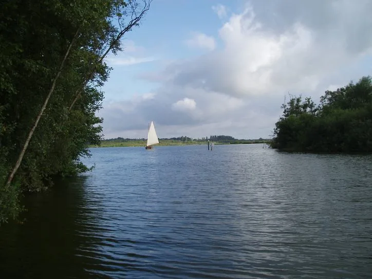
Irstead — village in Norfolk, England, UK.

Wikimedia Commons contributors — see linked file page for photographer and licence licence
Plan your visit
- Typical visit
- 3 h–6 h
- Nearest railway station
- Wroxham BVR · 6.4 km
- Free entry
- Family-friendly
- Dog-friendly
About
Irstead is a town, city, village or settlement in the United Kingdom. Address: NR12. Wikidata describes it as: "village in Norfolk, England, UK". Coordinates: 52.7295°, 1.5012°.
Photo gallery
Protected designations
- Site of Special Scientific Interest: Ant Broads and Marshes SSSI
- Area of Outstanding Natural Beauty: Norfolk Coast
- Ramsar wetland: Broadland
Designations sourced from Natural England open data under OGL v3.
From the Wikipedia article
Irstead is a village and former civil parish, now in the parish of Barton Turf, in the English county of Norfolk. It is 6.3 miles (10.1 km) north of Acle and 11 miles (18 km) north-east of Norwich, along the River Ant. Irstead's name is of Anglo-Saxon origin, although it is not listed in the Domesday Book. On 1 April 1935 the parish was abolished and merged with Barton Turf. In 1931 the parish had a population of 113. Irstead is part of the electoral ward of Hoveton & Tunstead for local elections and is part of the district of North Norfolk.
Excerpt from Wikipedia under CC BY-SA 4.0. See the source article linked in Sources below.
- Coordinates
- 52.7295, 1.5012
- County
- Norfolk
- District
- North Norfolk
- Parish
- Barton Turf
- Postcode
- NR12
- Parliamentary constituency
- North Norfolk
- Nearest railway station
- Wroxham BVR — 6.4 km
Sources
- wikidata: Q962629 (CC0)
- wikipedia: Irstead (CC BY-SA 4.0)
- commons: Irstead.jpg (CC BY-SA 4.0)
Other places nearby
Loading nearby places…
Nearby
 📷 3
📷 3Viewpoints · East Midlands
Barton Broad Boardwalk
Barton Broad Boardwalk is a viewpoint in the United Kingdom.
 📷 2
📷 2Wildlife reserves · East Midlands
Catfield Fen Reserve
Catfield Fen Reserve — nature reserve in Norfolk, England, UK.
 📷 3
📷 3Natural landmarks · East Midlands
Barton Broad
Barton Broad — lake in the United Kingdom.
 📷 3
📷 3Natural landmarks · East Midlands
Crome's Broad
Crome's Broad — lake in the United Kingdom.
 📷 4
📷 4Windmills · East Midlands
Boardman's Windmill
Boardman's Windmill — Grade II* listed building-listed windmill in england-east-midlands, United Kingdom.
 📷 3
📷 3Natural landmarks · East Midlands
Wherry Hathor
Wherry Hathor — a other in england-east-midlands, United Kingdom.
More towns in this region
 Flagship📷 3
Towns & cities · East Midlands
Aldborough
Aldborough — village in Norfolk, England, UK.
 Flagship📷 4
Towns & cities · East Midlands
Alderford
Alderford — village and civil parish in Norfolk, UK.
 Flagship📷 5
Towns & cities · East Midlands
Ashmanhaugh
Ashmanhaugh — village in Norfolk, England, UK.
 Flagship📷 3
Towns & cities · East Midlands
Attlebridge
Attlebridge — a village located in Broadland, United Kingdom.
Frequently asked questions
- Where is Irstead?
- Irstead is in Norfolk, the East Midlands, United Kingdom (postcode NR12), in the parish of Barton Turf.
- Is Irstead a protected site?
- Yes — Irstead is part of the Ant Broads and Marshes SSSI Site of Special Scientific Interest and the Norfolk Coast National Landscape (AONB).
- Is Irstead free to visit?
- Yes, Irstead is free to enter.
- How do I get to Irstead?
- The nearest railway station is Wroxham BVR, about 6.4 km away. Drivers can navigate to postcode NR12.