Natural landmarks · North East England
Hadrian's Wall Path
84-mile National Trail along the UNESCO Roman frontier — 7-day walk across Northumberland.

Russel Wills — CC BY-SA 2.0 via Wikimedia Commons licence
Plan your visit
- Typical visit
- 1 h–2 h
- Free entry
- Dog-friendly
About
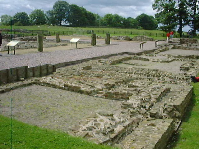
Hadrian's Wall Path is the 84-mile National Trail running along Hadrian's Wall from Bowness-on-Solway in Cumbria to Wallsend on the Tyne — opened 2003, traversing the UNESCO World Heritage Site Roman frontier with its surviving milecastles, forts (Vindolanda, Housesteads, Birdoswald) and views over the Northumberland fells. 7-day end-to-end walk.
Photo gallery
From the Wikipedia article
Hadrian's Wall Path is a long-distance footpath in the north of England, which became the 15th National Trail in 2003. It runs for 84 miles (135 km), from Wallsend on the east coast of England to Bowness-on-Solway on the west coast. For most of its length it is close to the remains of Hadrian's Wall, the defensive wall built by the Romans on the northern border of their empire. This is now recognised as part of the "Frontiers of the Roman Empire" World Heritage Site.
Excerpt from Wikipedia under CC BY-SA 4.0. See the source article linked in Sources below.
Background
Visiting
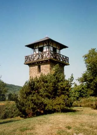
Both Newcastle and Carlisle are on the UK national railway network. The start of the walk at Wallsend can be easily reached by taking a local train from Newcastle to Wallsend Metro Station, which is the only station in the world with bilingual notices in English and Latin. From the station walk in the opposite direction to the shops along Station Road towards the tall observation tower of Segedunum Roman Fort and Museum. The Tyne Valley railway line runs between Newcastle and Carlisle, with stops at Wylam, Prudhoe, Corbridge, Hexham, Haydon Bridge, Bardon Mill, Haltwhistle, Brampton (1 mile from the town of Brampton) and Wetheral. For most of its length, the line is not within easy walking…
Sourced from Wikipedia under CC BY-SA 4.0.
- Coordinates
- 54.9908, -2.6011
- District
- Cumberland
- Parish
- Waterhead
- Postcode
- CA8 7DD
- Parliamentary constituency
- Carlisle
- Official site
- www.english-heritage.org.uk
Sources
- manual: hadrians-wall-path (manual)
- wikipedia: Hadrian's Wall Path (CC BY-SA 4.0)
Featured in this guide
Other places nearby
Loading nearby places…
Nearby
 📷 3
📷 3Museums · Scottish Lowlands
Birdoswald Roman Fort and Study Centre
Birdoswald Roman Fort and Study Centre — a museum in scotland-lowlands, United Kingdom.
 📷 5
📷 5Forts · Scottish Lowlands
Birdoswald Roman Fort
Birdoswald Roman Fort is a fort in the United Kingdom.
 📷 5
📷 5Hill forts · Scottish Lowlands
Banna
Banna — Roman fort in Cumbria, England.
 📷 4
📷 4Archaeological sites · North East England
Birdoswald
Birdoswald in England North East, United Kingdom.
 Flagship📷 3
UNESCO World Heritage · Scottish Lowlands
borders of the Roman Empire
borders of the Roman Empire — world heritage site (limes in Germany and UK).
 📷 3
📷 3Archaeological sites · Scottish Lowlands
Roman Altar
Roman Altar — a archaeological in scotland-lowlands, United Kingdom.
Other natural landmarks from this era
_(cropped).JPG?width=1200) 📷 5
📷 5Natural landmarks · London
George Stuart White
George Stuart White — Public artwork (statue).
 📷 5
📷 5Natural landmarks · London
Homage to Leonardo
Homage to Leonardo — Public artwork (statue).
 📷 5
📷 5Natural landmarks · London
John Keats
John Keats — Public artwork (statue) by Stuart Williamson.
 📷 5
📷 5Natural landmarks · London
José de San Martín
José de San Martín — Public artwork (statue).
More natural landmarks in this region
 Flagship📷 5
Natural landmarks · North East England
Brothers Water
Brothers Water — lake in Cumbria, England, UK.
 📷 5
📷 5Natural landmarks · North East England
Angle Tarn
Angle Tarn — lake near Patterdale, Cumbria, England, United Kingdom.
 📷 3
📷 3Natural landmarks · North East England
Angletarn Pikes
Angletarn Pikes — mountain in United Kingdom.
 📷 3
📷 3Natural landmarks · North East England
Ard Crags
Ard Crags — mountain in United Kingdom.
Frequently asked questions
- Where is Hadrian's Wall Path?
- Hadrian's Wall Path is in North-East England, United Kingdom (postcode CA8 7DD), in the parish of Waterhead.
- When was Hadrian's Wall Path built?
- Dates from the modern period.
- Is Hadrian's Wall Path free to visit?
- Yes, Hadrian's Wall Path is free to enter.
- How do I get to Hadrian's Wall Path?
- Drivers can navigate to postcode CA8 7DD. It sits within the Carlisle parliamentary constituency.