Archaeological sites · North East England
Hadrian's Wall
Also known as: Vallum Aelium
73-mile UNESCO World Heritage Roman frontier wall — Britain's most extensive Roman monument.

Wikimedia Commons contributors — see linked file page for photographer and licence licence
Plan your visit
- Typical visit
- 45 min–1.5 h
- Nearest railway station
- Haydon Bridge · 6.2 km
- Free entry
- Dog-friendly
About
Hadrian's Wall is a 73-mile (117 km) defensive fortification built by the Romans across northern Britain between AD 122 and 128 under the emperor Hadrian. Running from Wallsend on the River Tyne in the east to Bowness-on-Solway on the Solway Firth in the west, it marked the north-western frontier of the Roman Empire for nearly 300 years. The wall, originally up to 6 m high and 3 m wide, included 16 large forts (such as Housesteads, Chesters, Vindolanda and Birdoswald), 80 milecastles and 160 watchtowers. It was inscribed as a UNESCO World Heritage Site in 1987 and remains the most extensive Roman remain in Britain — walkable along the National Trail since 2003.
Photo gallery
From English Heritage
Hadrian’s Wall was the north-west frontier of the Roman empire for nearly 300 years. At 73 miles it marches across northern Britain from sea to sea. The most famous of all the frontiers of the Roman empire, Hadrian’s Wall was made a World Heritage Site in 1987.
Read more on the official property page.
Protected designations
- Site of Special Scientific Interest: River Eden and Tributaries SSSI
- Site of Special Scientific Interest: Roman Wall Escarpments SSSI
Designations sourced from Natural England open data under OGL v3.
From the Wikipedia article
Hadrian's Wall (also known as the Roman Wall or Picts' Wall) is a former defensive fortification of the Roman province of Britannia, begun in AD 122 in the reign of the Emperor Hadrian. Running from Wallsend on the River Tyne in the east to Bowness-on-Solway in the west of what is now northern England, it was a stone wall with large ditches in front and behind, stretching across the whole width of the island. Soldiers were garrisoned along the line of the wall in large forts, smaller milecastles, and intervening turrets. In addition to the wall's defensive military role, its gates may have been customs posts. Hadrian's Wall Path generally runs close along the wall. Almost all the standing masonry of the wall was removed in early modern times and used for local roads and farmhouses. None of it stands to its original height, but modern work has exposed much of the footings, and some segments display a few courses of modern masonry reconstruction. Many of the excavated forts on or near the wall are open to the public, and various nearby museums present its history. The largest Roman archaeological feature in Britain, it runs a total of 73 miles (117.5 kilometres). Regarded as a British cultural icon, Hadrian's Wall is one of Britain's major ancient tourist attractions. It was designated a UNESCO World Heritage Site in 1987. The turf-built Antonine Wall of AD 142 in what is now central Scotland, which briefly superseded Hadrian's Wall before being abandoned, was declared a World Heritage Site in 2008. Hadrian's Wall lies entirely within England and has never formed the Anglo-Scottish border, though it is sometimes loosely or colloquially described as such.
Excerpt from Wikipedia under CC BY-SA 4.0. See the source article linked in Sources below.
Background
Architecture
, who commissioned the wall's construction, found in 1834 in the River Thames in London, around 280 mi south of Hadrian's Wall]] Hadrian ended his predecessor Trajan's policy of expanding the empire and instead focused on defending the current borders, namely at the time Britain. the entire length of the wall was built with an alternating series of forts, each housing 600 men, and manned milecastles, operated by "between 12 and 20 men". It took six years to build most of Hadrian's Wall with the work coming from three Roman legions – the Legio II Augusta, Legio VI Victrix, and Legio XX Valeria Victrix, totalling 15,000 soldiers, plus some members of the Roman fleet. The building of the wall…
Visiting
Although Hadrian's Wall was declared a World Heritage Site in 1987, it remains unguarded, enabling visitors to climb and stand on the wall, although this is not encouraged, as it could damage the historic structure. On 13 March 2010, a public event Illuminating Hadrian's Wall took place, which saw the route of the wall lit with 500 beacons. On 31 August and 2 September 2012, there was a second illumination of the wall as a digital art installation called "Connecting Light", which was part of the London 2012 Festival. In 2018, the organisations which manage the Great Wall of China and Hadrian's Wall signed an agreement to collaborate for the growth of tourism and for historical and cultural…
Sourced from Wikipedia under CC BY-SA 4.0.
- Coordinates
- 55.0246, -2.3000
- District
- Northumberland
- Parish
- Haydon
- Postcode
- NE47 6NW
- Parliamentary constituency
- Hexham
- Established
- 122
- Nearest railway station
- Haydon Bridge — 6.2 km
- Official site
- www.english-heritage.org.uk
Sources
- wikidata: Q57357 (CC0)
- wikipedia: Hadrian's Wall (CC BY-SA 4.0)
- commons: Section of Hadrian's Wall 1.jpg (CC BY-SA 4.0)
Featured in these 7 guides
Itinerary
Every UNESCO World Heritage Site in the UK
Thirty-three sites of outstanding universal value, from Hadrian's Wall to the Forth Bridge.
Itinerary
Hadrian's Wall: walking the Roman frontier
73 miles of Roman engineering, from Wallsend to Bowness-on-Solway.
Itinerary
Roman Britain in a week
Hadrian's Wall, Bath, London, Caerwent, Vindolanda — the empire's northernmost province.
Itinerary
Hadrian's Wall in 4 days
From Bowness-on-Solway to Wallsend with the best forts in between.
Itinerary
World Heritage Sites of Great Britain
The most authoritative places in the country.
Itinerary
Hadrian's Wall weekend
The forts of the central sector: Housesteads, Vindolanda, Birdoswald.
Other places nearby
Loading nearby places…
Nearby
 📷 3
📷 3Archaeological sites · Scottish Lowlands
Milecastle 35 (Sewingshields)
Milecastle 35 (Sewingshields) — a archaeological in scotland-lowlands, United Kingdom.
📷 3Other places · North East England
Milecastle 35
Milecastle 35 in England North East, United Kingdom.
 📷 3
📷 3Archaeological sites · Scottish Lowlands
Turret 34A (Grindon West)
Turret 34A (Grindon West) — a archaeological in scotland-lowlands, United Kingdom.
 📷 3
📷 3Archaeological sites · Scottish Lowlands
Grindon School temporary camp
Grindon School temporary camp — a archaeological in scotland-lowlands, United Kingdom.
B&Bs · Scottish Lowlands
Old Repeater Station
Old Repeater Station — a bed-and-breakfast in scotland lowlands.
 📷 3
📷 3Archaeological sites · Scottish Lowlands
Turret 35A (Sewingshields)
Turret 35A (Sewingshields) — a archaeological in scotland-lowlands, United Kingdom.
Other archaeological sites from this era


More archaeological sites in this region
 📷 3
📷 3Archaeological sites · North East England
Force Crag mines and barytes mill and a prehistoric cairnfield
Force Crag mines and barytes mill and a prehistoric cairnfield — archaeological site in Above Derwent, Allerdale, England, UK.
 📷 3
📷 3Archaeological sites · North East England
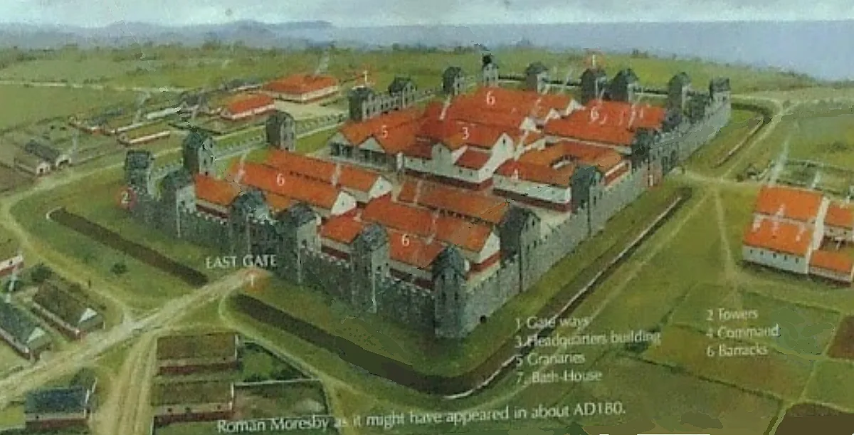
Gabrosentum Roman Fort
Gabrosentum Roman Fort — Roman fort in Parton, Copeland, England, UK.
 📷 3
📷 3Archaeological sites · North East England
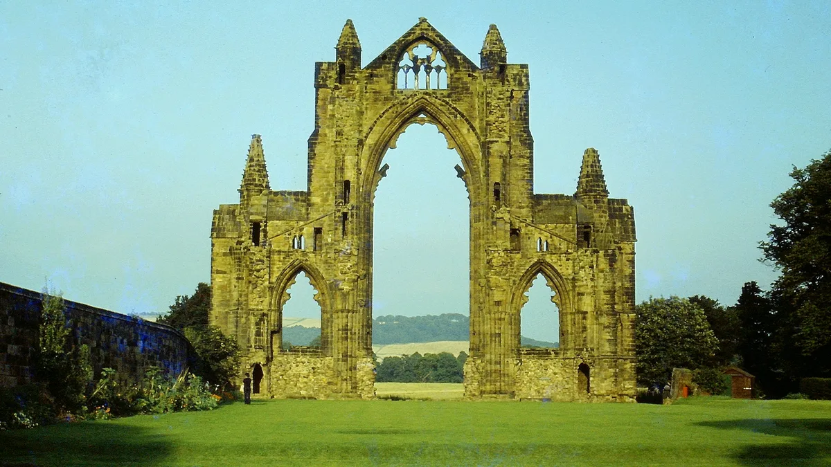
Gisborough Priory Augustinian monastery: late Saxon settlement, cemetery, monastic precinct and dovecote
Gisborough Priory Augustinian monastery: late Saxon settlement, cemetery, monastic precinct and dovecote — archaeological site in Guisborough, Redcar and Cleveland, England, UK.

Archaeological sites · North East England
Lune Forest
Lune Forest — forest in County Durham, England, UK.
Frequently asked questions
- Where is Hadrian's Wall?
- Hadrian's Wall is in North-East England, United Kingdom (postcode NE47 6NW), in the parish of Haydon.
- When was Hadrian's Wall built?
- Built or established in 122.
- Who owns Hadrian's Wall?
- Hadrian's Wall is owned by Various private and public ownerships.
- Is Hadrian's Wall a protected site?
- Yes — Hadrian's Wall is part of the River Eden and Tributaries SSSI Site of Special Scientific Interest and the Roman Wall Escarpments SSSI Site of Special Scientific Interest.
- How do I get to Hadrian's Wall?
- The nearest railway station is Haydon Bridge, about 6.2 km away. Drivers can navigate to postcode NE47 6NW.