Towns & cities · West Midlands
Great Warford
Great Warford — village and civil parish in Cheshire East, United Kingdom.

Wikimedia Commons contributors — see linked file page for photographer and licence licence
Plan your visit
- Typical visit
- 3 h–6 h
- Nearest railway station
- Chelford · 2.1 km
- Free entry
- Family-friendly
- Dog-friendly
About
Great Warford is a town, city, village or settlement in the United Kingdom. Recent population estimates put it at around 615 people. Wikidata describes it as: "village and civil parish in Cheshire East, United Kingdom". Coordinates: 53.2890°, -2.2750°.
Photo gallery
From the Wikipedia article
Great Warford () is a village and civil parish in the unitary authority of Cheshire East and the ceremonial county of Cheshire, England. A predominantly farming settlement, Great Warford has existed for approximately a thousand years. Today, in addition to agriculture, it's noted for its roles in private healthcare and property development. The population stands at 1710 inhabitants. The village lacks a distinct municipal centre in terms of population density and significance. Warford Park development houses around 300 residents and boasts amenities like an on-site health/leisure club, tennis courts, the Warford Park Bowling Club, and expansive gardens, lakes, and parkland. Although Great Warford lacks direct national transport links, being without a railway or bus station, it's strategically positioned in "The Golden Triangle" formed by Alderley Edge, Knutsford, and Wilmslow. As such, it benefits from nearby schools, shops, restaurants, and entertainment venues. The proximity to the North West's expansive motorway network allows accessibility without compromising the village's rural charm. Other local attractions include Manchester Airport, a golf club, and numerous footpaths that appeal to tourists.
Excerpt from Wikipedia under CC BY-SA 4.0. See the source article linked in Sources below.
- Coordinates
- 53.2890, -2.2750
- District
- Cheshire East
- Parish
- Great Warford
- Postcode
- SK9 7TW
- Parliamentary constituency
- Tatton
- Population
- 615
- Nearest railway station
- Chelford — 2.1 km
- Official site
- web.archive.org
Sources
- wikidata: Q981121 (CC0)
- wikipedia: Great Warford (CC BY-SA 4.0)
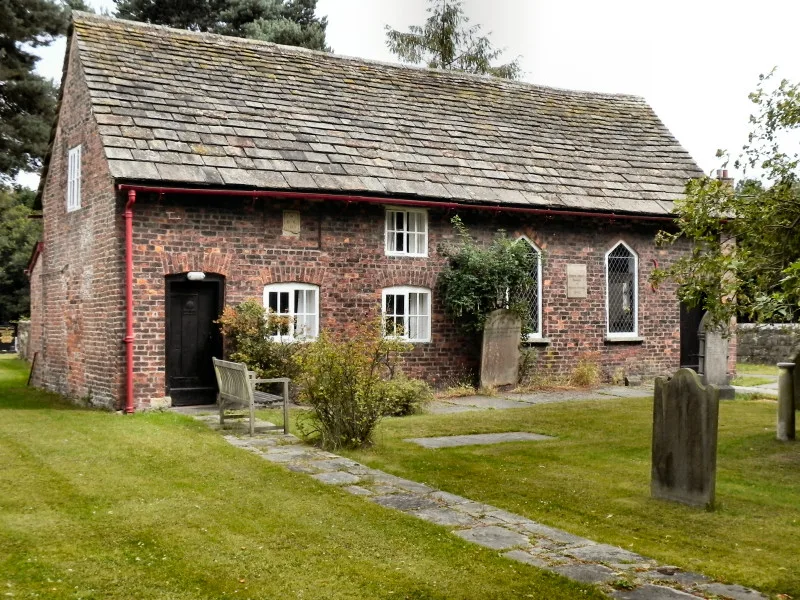
- commons: Great Warford Baptist Chapel.jpg (CC BY-SA 4.0)
Other places nearby
Loading nearby places…
Nearby
 📷 3
📷 3Historic churches · West Midlands
Baptist Chapel, Great Warford
Baptist Chapel, Great Warford — church in Cheshire East, Cheshire, England, UK.
 📷 3
📷 3Towns & cities · West Midlands
Soss Moss
Soss Moss — village in Cheshire, England, UK.
 📷 3
📷 3Historic churches · West Midlands
St Mary's Church, Nether Alderley
St Mary's Church, Nether Alderley — church in Nether Alderley, Cheshire, England, UK.
 📷 3
📷 3Historic churches · West Midlands
Churchyard cross at St Mary's Church
Churchyard cross at St Mary's Church — a Grade II*-listed church in england-west-midlands, United Kingdom.
 📷 3
📷 3Towns & cities · West Midlands
Nether Alderley
Nether Alderley — village and civil parish in Cheshire East, England.
 📷 3
📷 3Memorials & monuments · West Midlands
Alderley Cross
Alderley Cross — a memorial in england-west-midlands, United Kingdom.
More towns in this region
 Flagship📷 3
Towns & cities · West Midlands
Adderbury
Adderbury — village and civil parish in Cherwell district, Oxfordshire, England.
 Flagship📷 3
Towns & cities · West Midlands
Admington
Admington — village in Warwickshire, England, UK.
 Flagship📷 3
Towns & cities · West Midlands
Aldington
Aldington — village in Worcestershire, United Kingdom.
 Flagship📷 5
Towns & cities · West Midlands
Anstey
Anstey — large village in Leicestershire, England.
Frequently asked questions
- Where is Great Warford?
- Great Warford is in the West Midlands, United Kingdom (postcode SK9 7TW), in the parish of Great Warford.
- Is Great Warford free to visit?
- Yes, Great Warford is free to enter.
- How do I get to Great Warford?
- The nearest railway station is Chelford, about 2.1 km away. Drivers can navigate to postcode SK9 7TW.