Hill forts · South West England
Giant's Quoit
Giant's Quoit — dolmen in Cornwall, England, UK.

Wikimedia Commons contributors — see linked file page for photographer and licence licence
Plan your visit
- Typical visit
- 1 h–2 h
- Nearest railway station
- Camborne · 2.5 km
- Free entry
- Family-friendly
- Dog-friendly
About
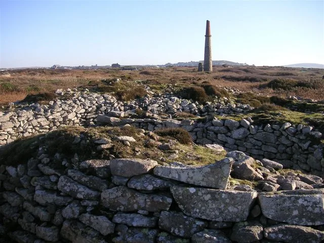
Giant's Quoit is a hill fort in the United Kingdom. Heritage designation: scheduled monument. Wikidata describes it as: "dolmen in Cornwall, England, UK". Coordinates: 50.1882°, -5.2933°.
Photo gallery
Protected designations
- Site of Special Scientific Interest: West Cornwall Bryophytes SSSI
- Area of Outstanding Natural Beauty: Cornwall
Designations sourced from Natural England open data under OGL v3.
From the Wikipedia article
Carwynnen Quoit (grid reference SW650372) is a dolmen belonging to the Neolithic period, at Carwynnen near Camborne in west Cornwall. It is also known as 'The Giant's Quoit', 'The Giant's Frying Pan', 'Pendarvis Quoit' and 'Pendarves Quoit'. It collapsed in 1966 and was re-erected in 2014.
Excerpt from Wikipedia under CC BY-SA 4.0. See the source article linked in Sources below.
Background
History
The site was first recorded by the Welsh antiquarian Edward Lhuyd around 1700 and a symbol of the cromlech appeared on Martyn's 1748 map of Cornwall. These are early references to ancient sites. The first plan and elevation was by Cornish antiquarian William Borlase in 1769. In his 1803 work Coloured Figures of English Fungi or Mushrooms, the English naturalist James Sowerby illustrated a yellow dust lichen, later identified as Chrysothrix chlorina, that was growing on the structure. In 1840, the field was recorded as the Frying Pan Field on the Tithe Apportionment Schedule. In 1891, it was recorded that "curious marks" had been noticed some years previously, "on a stone under a thorn tree,…
Description
Carwynnen Quoit is one of an ancient and rare group of monuments and can be found at Carwynnen in Cornwall. It is a portal dolmen belonging to the Neolithic period, built around 3000 BC, one of the few Cornish portal dolmens to be found outside the Penwith peninsula. It is situated on a gentle west-facing slope between two small tributaries to the Red River. The dolmen stands to a height of 1.5 metres with a capstone measuring around 3.3 metres long by 2.5 metres wide and 30 cm thick and weighs around 10 tons.
Sourced from Wikipedia under CC BY-SA 4.0.
- Coordinates
- 50.1882, -5.2933
- District
- Cornwall
- Parish
- Camborne
- Postcode
- TR14 9LR
- Parliamentary constituency
- Camborne and Redruth
- Nearest railway station
- Camborne — 2.5 km
- Official site
- www.giantsquoit.org
Sources
- wikidata: Q5558329 (CC0)
- wikipedia: Carwynnen Quoit (CC BY-SA 4.0)
- commons: Carwynnen Quoit - geograph.org.uk - 4187153.jpg (CC BY-SA 4.0)
Other places nearby
Loading nearby places…
Nearby
 📷 3
📷 3Burial mounds & barrows · South West England
Carwynnen Quoit
Carwynnen Quoit — a other in england-south-west, United Kingdom.
 📷 3
📷 3Historic churches · South West England
Wayside cross in St John's churchyard, Treslothan
Wayside cross in St John's churchyard, Treslothan — a Grade II*-listed church in england-south-west, United Kingdom.
📷 3Memorials & monuments · South West England
Treslothan War Memorial
Treslothan War Memorial — Grade II listed building-listed memorial in england-south-west, United Kingdom.
 📷 5
📷 5Historic churches · South West England
Troon, Cornwall
Troon, Cornwall — a church in england-south-west, United Kingdom.
 📷 3
📷 3Historic houses · South West England
Pump Engine House
Pump Engine House — a historic house in england-south-west, United Kingdom.
 📷 5
📷 5Historic churches · South West England
Barripper
Barripper is a village in west Cornwall, England, United Kingdom, (grid reference SW633382) approximately one mile south-west of Camborne . The village has a public house named the St Michael's Mount
More places in this region
 📷 5
📷 5Hill forts · South West England
Ballowall Barrow
Ballowall Barrow — archaeological site in St Just, Cornwall, England, UK.
 📷 5
📷 5Hill forts · South West England
Barnstaple Castle
Barnstaple Castle — castle in Devon, England, UK.
 📷 5
📷 5Hill forts · South West England
Bartinney Castle
Bartinney Castle — Iron Age enclosure in Cornwall, England, UK.
 📷 5
📷 5Hill forts · South West England
Berry's Wood
Berry's Wood — iron Age hill fort in south Devon, England, UK.
Frequently asked questions
- Where is Giant's Quoit?
- Giant's Quoit is in South-West England, United Kingdom (postcode TR14 9LR), in the parish of Camborne.
- Is Giant's Quoit a listed building?
- Giant's Quoit is officially recognised as scheduled monument listed.
- Is Giant's Quoit a protected site?
- Yes — Giant's Quoit is part of the West Cornwall Bryophytes SSSI Site of Special Scientific Interest and the Cornwall National Landscape (AONB).
- Is Giant's Quoit free to visit?
- Yes, Giant's Quoit is free to enter.
- How do I get to Giant's Quoit?
- The nearest railway station is Camborne, about 2.5 km away. Drivers can navigate to postcode TR14 9LR.