Towns & cities · Central Scotland
Dalmuir
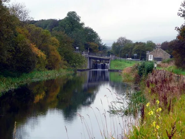
Dalmuir — village in West Dunbartonshire, Scotland, UK.

Wikimedia Commons contributors — see linked file page for photographer and licence licence
Plan your visit
- Typical visit
- 3 h–6 h
- Nearest railway station
- Dalmuir · 0.6 km
- Free entry
- Family-friendly
- Dog-friendly
About
Dalmuir is a town, city, village or settlement in the United Kingdom. Wikidata describes it as: "village in West Dunbartonshire, Scotland, UK". Coordinates: 55.9086°, -4.4342°.
Photo gallery
From the Wikipedia article
Dalmuir (; Scottish Gaelic: Dail Mhoire) is an area nine miles (fourteen kilometres) northwest of Glasgow, Scotland, on the western side of Clydebank, and part of West Dunbartonshire Council Area. The name is a lowland Scots derivation of the Gaelic meaning Big Field. The area was originally two separate villages with Dalmuir Shore joining with Clydebank in 1886 and Dalmuir Village in 1906, during a period of rapid industrialisation and expansion. Dalmuir is bounded by the village of Old Kilpatrick to the west, the Mountblow and Parkhall housing schemes to the north, and the Clydebank town centre area to the east. To the south is the River Clyde.
Excerpt from Wikipedia under CC BY-SA 4.0. See the source article linked in Sources below.
Background
History
The area was at the most northerly-west part of the Roman Empire with Antonine Wall forts to the west at Old Kilpatrick and north at Duntocher from AD 142 until it was abandoned in AD 162. There was a brief re-occupation for a few years, starting in AD 208. In 1281 the land was first recorded as owned by Walter Spreul, Steward of Malcolm, Earl of Levenax, in the "Charter Records of the land of Dalmuir or Dalmore". From the 13th to the early 19th century the land was held by the Spreull family. In the 1750s the area was called Damur or Dalmar and in 1768, Dalmuir Burnfoot. In the 18th century the area was mostly arable land, undivided moor capable of grazing 266 sheep, with a small mansion,…
Sourced from Wikipedia under CC BY-SA 4.0.
- Coordinates
- 55.9086, -4.4342
- District
- West Dunbartonshire
- Postcode
- G81 4HT
- Parliamentary constituency
- West Dunbartonshire
- Nearest railway station
- Dalmuir — 0.6 km
- Official site
- www.ststephensdalmuir.co.uk
Sources
- wikidata: Q1158064 (CC0)
- wikipedia: Dalmuir (CC BY-SA 4.0)
- commons: Dalmuir drop lock.jpg (CC BY-SA 4.0)
Other places nearby
Loading nearby places…
Nearby
 📷 3
📷 3Memorials & monuments · Central Scotland
William Beardmore & Company Ltd War Memorial
William Beardmore & Company Ltd War Memorial — a memorial in scotland-central, United Kingdom.
📷 3Public art & sculpture · Central Scotland
Beardmore Sculpture
Beardmore Sculpture — a public art in scotland-central, United Kingdom.
 📷 5
📷 5Harbours & ports · Central Scotland
Park Quay
Park Quay — port and quay on the River Clyde, Renfrewshire, Scotland, UK, now disused.
 📷 3
📷 3Memorials & monuments · Central Scotland
Robert Currie Memorial
Robert Currie Memorial — a memorial in scotland-central, United Kingdom.
 📷 3
📷 3Memorials & monuments · Central Scotland
The Lancastria Memorial
The Lancastria Memorial — a memorial in scotland-central, United Kingdom.
 📷 3
📷 3Harbours & ports · Central Scotland
Rashielee Quay
Rashielee Quay — port on the south bank of the River Clyde, Renfrewshire, Scotland, UK, now disused.
More towns in this region
 Flagship📷 3
Towns & cities · Central Scotland
Airth
Airth — village in Falkirk, Scotland, UK.
 Flagship📷 5
Towns & cities · Central Scotland
Avonbridge
Avonbridge — village in Falkirk, Scotland, UK.
 Flagship📷 3
Towns & cities · Central Scotland
Banknock
Banknock — village in Falkirk, Scotland, UK.
 Flagship📷 3
Towns & cities · Central Scotland
Dundee
Dundee — city in Scotland, UK.
Frequently asked questions
- Where is Dalmuir?
- Dalmuir is in central Scotland, United Kingdom (postcode G81 4HT).
- Is Dalmuir free to visit?
- Yes, Dalmuir is free to enter.
- How do I get to Dalmuir?
- The nearest railway station is Dalmuir, about 0.6 km away. Drivers can navigate to postcode G81 4HT.