Mountains & hills · Central Scotland
Cockleroy
Also known as: A' Chachaileith Ruadh, Cocklerue
Cockleroy — Named summit at 278 m.

Wikimedia Commons contributors — see linked file page for photographer and licence licence
Plan your visit
- Typical visit
- 3 h–8 h
- Best time of year
- Late spring – early autumn (May–Oct)
- Nearest railway station
- Linlithgow · 3.1 km
- Free entry
- Dog-friendly
About
Cockleroy is a named summit in the United Kingdom. Also known as: A' Chachaileith Ruadh, Cocklerue. Wikidata describes it as: "Named summit at 278 m.". Coordinates: 55.9517°, -3.6199°.
Photo gallery
From the Wikipedia article
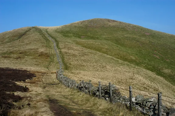
Cockleroi or Cockleroy is a prominent hill in Scotland. It is Linlithgow's local hill. On its top there are some remains of an Iron Age's hill fort.
Excerpt from Wikipedia under CC BY-SA 4.0. See the source article linked in Sources below.
- Coordinates
- 55.9517, -3.6199
- District
- West Lothian
- Postcode
- EH49 6PN
- Parliamentary constituency
- Bathgate and Linlithgow
- Nearest railway station
- Linlithgow — 3.1 km
- Official site
- books.google.com
Sources
- osm: n257151972 (ODbL)
- wikipedia: Cockleroi (CC BY-SA 4.0)
- commons: Footpath to Cockleroi - geograph.org.uk - 1147856.jpg (CC BY-SA 4.0)
Other places nearby
Loading nearby places…
Nearby
Vineyards · Central Scotland
Cockleroy
Cockleroy — a UK vineyard in scotland central, producing English or Welsh wine from cool-climate grape varieties.
 📷 3
📷 3Hill forts · Central Scotland
Cockleroy Hillfort
Cockleroy Hillfort — a hill fort in scotland-central, United Kingdom.
 📷 5
📷 5Memorials & monuments · Central Scotland
Kipps
Kipps — category C listed building-listed memorial in scotland-central, United Kingdom.
 📷 3
📷 3Public art & sculpture · Central Scotland
Pluto - Kirkhill Pillar Project
Pluto - Kirkhill Pillar Project — a public art in scotland-central, United Kingdom.
Mountain bike trails · Central Scotland
Red Route
Red Route — a mtb trail in scotland central.
Mountain bike trails · Central Scotland
Blue Route
Blue Route — a mtb trail in scotland central.
More mountains in this region
 📷 3
📷 3Mountains & hills · Central Scotland
Abbey Hill
Abbey Hill — Named summit at 278 m.
 📷 3
📷 3Mountains & hills · Central Scotland
Aberlady Bay
Aberlady Bay — bay on the north coast of East Lothian, Scotland, UK.
 📷 3
📷 3Mountains & hills · Central Scotland
Allermuir Hill
Allermuir Hill — Named summit at 493 m.
 📷 3
📷 3Mountains & hills · Central Scotland
Ardnandave
Ardnandave — Named summit at 715 m.
Frequently asked questions
- Where is Cockleroy?
- Cockleroy is in central Scotland, United Kingdom (postcode EH49 6PN).
- Is Cockleroy free to visit?
- Yes, Cockleroy is free to enter.
- How do I get to Cockleroy?
- The nearest railway station is Linlithgow, about 3.1 km away. Drivers can navigate to postcode EH49 6PN.