Islands · North West England
Chapel Island
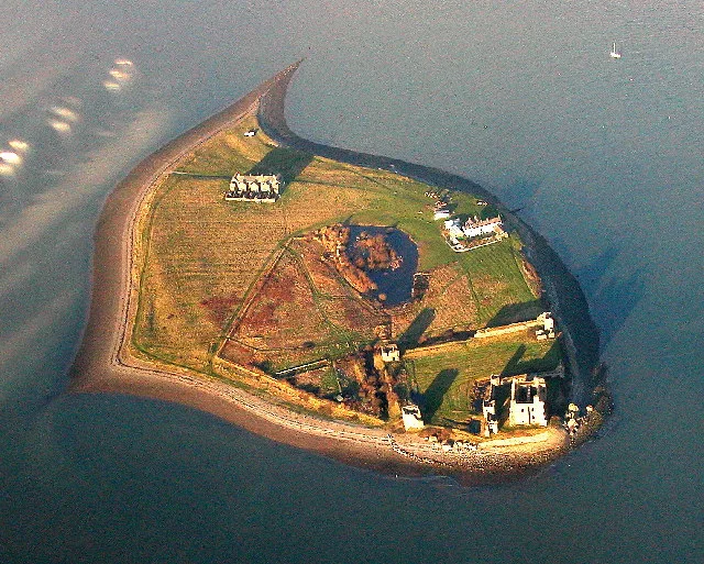
Chapel Island — island in Morecambe Bay, United Kingdom.

Wikimedia Commons contributors — see linked file page for photographer and licence licence
Plan your visit
- Typical visit
- 4 h–12 h
- Nearest railway station
- Ulverston · 4.2 km
- Free entry
- Dog-friendly
About
Chapel Island is a island in the United Kingdom. Part of British Isles. Wikidata describes it as: "island in Morecambe Bay, United Kingdom". Coordinates: 54.1741°, -3.0416°.
Photo gallery
Protected designations
- Site of Special Scientific Interest: Morecambe Bay SSSI
- Ramsar wetland: Morecambe Bay
Designations sourced from Natural England open data under OGL v3.
From the Wikipedia article
Chapel Island is a limestone outcrop that lies in the Leven estuary of Morecambe Bay in England, less than one mile (1.6 km) from the shoreline at Bardsea in the area known as Ulverston Sands. It is located at 54.1741°N 3.0416°W / 54.1741; -3.0416 (OS grid ref. SD 321759). It is one of the Islands of Furness in the county of Cumbria, in the area of the historic county of Lancashire ("Lancashire north of the sands"). The island is approximately 450 yards (410 m) long and just over 100 yards (91 m) at its widest. Its area is about 7.5 acres (3.0 hectares). Chapel Island, known as Harlesyde Isle in 1593, got its present name in 1795. The name was coined by Mrs. Radcliffe in her book ‘Tour of the Lakes’. In the 14th century Augustinian canons from nearby Conishead Priory built a small chapel on the island to serve the needs of travellers and fishermen working in the Leven fisheries. The Island lies on the path of the ancient crossing from Cartmel to Conishead and would have been a place of haven to travellers caught out by the tide. Tradition describes its purpose to be the meeting for prayers with the travellers who cross the bay. In 1843 Jopling notes that the crossing passed to the south of the island, implying that the route past the island varied over time. Nothing remains of the original chapel, although Thomas West noted that these ruins were still extant in 1774. In 1821 Colonel Thomas Richard Gale Braddyll commenced building the modern-day Conishead Priory and to enhance the view from the priory he had a mock pseudo-classical ruin built on the island. This chapel ruin is now sometimes mistaken for the remains of the original. There was also a cottage on the island, probably also built in the early 19th century, which was ostensibly occupied by fishermen. It is mentioned that fishermen occupy the cottage ‘at the instance of the owner of the Priory who has erected a cottage close to the ruins. In 1851 the cottage was occupied by Thomas Benson, a mariner, his…
Excerpt from Wikipedia under CC BY-SA 4.0. See the source article linked in Sources below.
- Coordinates
- 54.1741, -3.0416
- District
- Westmorland and Furness
- Parish
- Ulverston
- Postcode
- LA12 9QD
- Parliamentary constituency
- Barrow and Furness
- Nearest railway station
- Ulverston — 4.2 km
Sources
- wikidata: Q5073034 (CC0)
- wikipedia: Chapel Island (CC BY-SA 4.0)
- commons: Chapel Island - geograph.org.uk - 473050.jpg (CC BY-SA 4.0)
Other places nearby
Loading nearby places…
Nearby
 📷 3
📷 3Follies · North West England
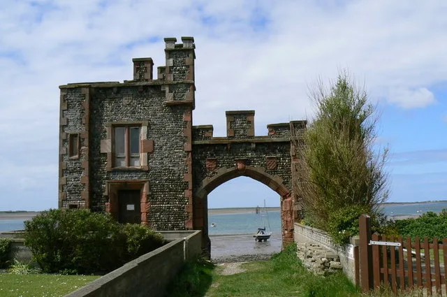
Chapel (folly)
Chapel (folly) — a folly in england-north-west, United Kingdom.
 📷 4
📷 4Abbeys & priories · North West England
Conishead Priory
Conishead Priory is a large Gothic Revival building on the Furness peninsula near Ulverston in Cumbria. The priory's name translates literally as "King's Hill Priory". Since 1976, the building has bee
 📷 5
📷 5Historic churches · North West England
Manjushri Kadampa Meditation Centre
Manjushri Kadampa Meditation Centre — a church in england-north-west, United Kingdom.
 📷 3
📷 3Memorials & monuments · North West England
Tower On Hermitage Hill At Sd 3301 4761
Tower On Hermitage Hill At Sd 3301 4761 — Grade II listed building-listed memorial in england-north-west, United Kingdom.
 📷 5
📷 5Historic bridges · North West England
Leven Viaduct
Leven Viaduct is a historic bridge in the United Kingdom.
 📷 4
📷 4Historic bridges · North West England
Rolling Bridge Over Ulverston Canal And Associated Accumulator Tower
Rolling Bridge Over Ulverston Canal And Associated Accumulator Tower — Grade II listed building-listed bridge in england-north-west, United Kingdom.
More places in this region
 Flagship📷 3
Islands · North West England
Chicken Rock
Chicken Rock — the southernmost island administered by the Isle of Man.
 Flagship📷 3
Islands · North West England
Great Britain
Great Britain — island in the North Atlantic Ocean off the northwest coast of continental Europe.
 Flagship📷 3
Islands · North West England
Piel Island
Piel Island — island in United Kingdom.
 Flagship📷 3
Islands · North West England
Roa Island
Roa Island — island in Morecambe Bay, Cumbria, England, UK.
Frequently asked questions
- Where is Chapel Island?
- Chapel Island is in North-West England, United Kingdom (postcode LA12 9QD), in the parish of Ulverston.
- Is Chapel Island a protected site?
- Yes — Chapel Island is part of the Morecambe Bay SSSI Site of Special Scientific Interest and the Morecambe Bay Ramsar wetland.
- Is Chapel Island free to visit?
- Yes, Chapel Island is free to enter.
- How do I get to Chapel Island?
- The nearest railway station is Ulverston, about 4.2 km away. Drivers can navigate to postcode LA12 9QD.