Natural landmarks · Northern Ireland
Carrickfergus
Also known as: Carraig Fhearghais
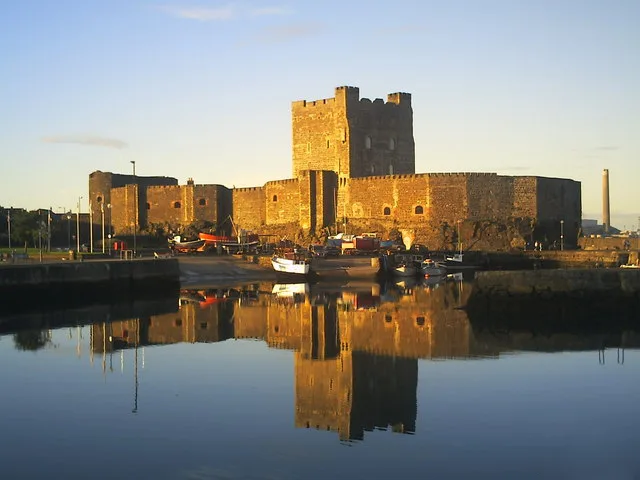
Carrickfergus in Northern Ireland, United Kingdom.

Raymond Bell — CC BY-SA 2.0 via Wikimedia Commons licence
_at_Carrickfergus_-_geograph.org.uk_-_5891412.jpg)
Plan your visit
- Typical visit
- 1 h–2 h
- Free entry
- Dog-friendly
About
Carrickfergus is a place of interest in Northern Ireland, United Kingdom — drawn from open-data sources for visitor reference. See the linked Wikipedia article for the full description.
Photo gallery
From the Wikipedia article
Carrickfergus (from Irish Carraig Fhearghais [ˌkaːɾˠəɟ ˈaɾˠɣəʃ], meaning "Fergus' rock") is a large town in County Antrim, Northern Ireland. It sits on the north shore of Belfast Lough, 11 miles (18 km) from Belfast. The town had a population of 28,141 at the 2021 census. It is County Antrim's oldest town and one of the oldest towns in Ireland as a whole. Carrickfergus Castle, built in the late 12th century at the behest of Anglo-Norman knight John de Courcy, was the capital of the Earldom of Ulster. After the earldom's collapse, it remained the only English outpost in Ulster for the next four centuries. Carrickfergus was the administrative centre for Carrickfergus Borough Council, before this was amalgamated into the Mid and East Antrim District Council in 2015, and forms part of the Belfast Metropolitan Area. It is also a townland of 65 acres, a civil parish and a barony.
Excerpt from Wikipedia under CC BY-SA 4.0. See the source article linked in Sources below.
Background
Description
Throughout the course of The Troubles, there was a paramilitary presence in the town, namely the Ulster Volunteer Force and Ulster Defence Association. Census figures show that the Catholic population of Carrickfergus declined from 16.2% in 1971 to 9.56% in 2011.
Sourced from Wikipedia under CC BY-SA 4.0.
- Coordinates
- 54.7136, -5.8075
- District
- Mid and East Antrim
- Postcode
- BT38 7BN
- Parliamentary constituency
- East Antrim
- Official site
- www.northsouthministerialcouncil.org
Sources
- wikidata: Q1020354 (CC0)
- wikipedia: Carrickfergus (CC BY-SA 4.0)
Other places nearby
Loading nearby places…
Nearby
📷 3Memorials & monuments · Northern Ireland
King William III Monument
King William III Monument — a memorial in northern-ireland, United Kingdom.
 📷 5
📷 5Castles · Northern Ireland
Carrickfergus Castle
Carrickfergus Castle is a castle in the United Kingdom.
 📷 4
📷 4Battlefields & battle sites · Northern Ireland
Battle of Carrickfergus
Battle of Carrickfergus in Northern Ireland, United Kingdom.
 📷 3
📷 3Galleries · Northern Ireland
Lauryn James
Lauryn James — a gallery in northern-ireland, United Kingdom.
 📷 3
📷 3Public art & sculpture · Northern Ireland
arts
arts — a public art in northern-ireland, United Kingdom.
 📷 4
📷 4Natural landmarks · Northern Ireland
Carrickfergus Lifeboat Station
Carrickfergus Lifeboat Station in Northern Ireland, United Kingdom.
More natural landmarks in this region
 Flagship📷 4
Natural landmarks · Northern Ireland
Lough Erne
Lough Erne — lake in County Fermanagh, Northern Ireland, UK.
 Flagship📷 4
Natural landmarks · Northern Ireland
Lough Neagh
Lough Neagh — large lake in Northern Ireland.
 📷 3
📷 3Natural landmarks · Northern Ireland
Ballysaggart Lough
Ballysaggart Lough — lake in the United Kingdom.
 📷 5
📷 5Natural landmarks · Northern Ireland
Belmore Mountain
Belmore Mountain — mountain in the United Kingdom.
Frequently asked questions
- Where is Carrickfergus?
- Carrickfergus is in Northern Ireland, United Kingdom (postcode BT38 7BN).
- Is Carrickfergus free to visit?
- Yes, Carrickfergus is free to enter.
- How do I get to Carrickfergus?
- Drivers can navigate to postcode BT38 7BN. It sits within the East Antrim parliamentary constituency.