Islands · Northern Ireland
Boa Island
Boa Island is a island in the United Kingdom.

Wikimedia Commons contributors — see linked file page for photographer and licence licence
Plan your visit
- Typical visit
- 4 h–12 h
- Free entry
- Dog-friendly
About
Boa Island is a island in the United Kingdom. Coordinates: 54.5167°, -7.8333°. This entry is part of The Great Britain Guide, a free, ad-free, open-data tourist directory.
Photo gallery
From the Wikipedia article
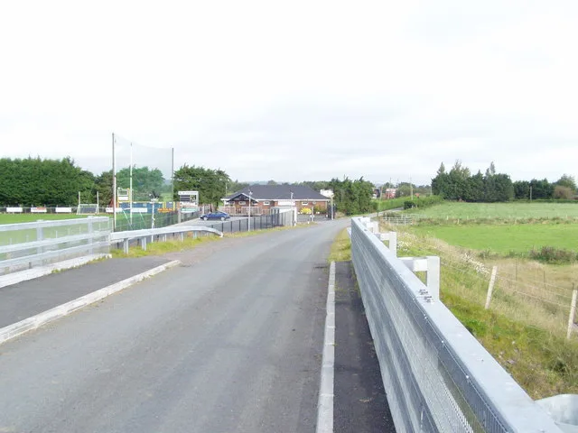
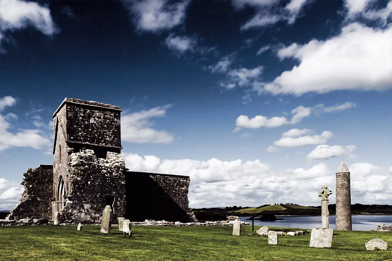
Boa Island (from Irish Badhbha) is an island near the north shore of Lower Lough Erne in County Fermanagh, Northern Ireland. It is 16 miles (26 km) from Enniskillen town. It is the largest island in Lough Erne, approximately 5 miles (8.0 km) long, and relatively narrow. The A47 road goes through the length of the island and joins each end of the island to the mainland by bridges leading west toward Castle Caldwell and east toward Kesh. Boa Island features a counterscarp rath (grid ref: H0744 6250) as well as carved stones, graveyard and enclosure (grid ref: H0852 6197), all in Dreenan townland and all Scheduled Historic Monuments. The two sided Lustymore stone figure was moved here in 1939 from the nearby island of the same name. It and the similar Dreenan figure are collectively known as the archaeological significant Boa Island figures. Both are thought to date from the 1st century AD. The oldest stone monument on the island is a denuded cairn at Inishkeeragh Bridge near the southern tip of the island.
Excerpt from Wikipedia under CC BY-SA 4.0. See the source article linked in Sources below.
- Coordinates
- 54.5167, -7.8333
- District
- Fermanagh and Omagh
- Postcode
- BT93 8AE
- Parliamentary constituency
- Fermanagh and South Tyrone
Sources
- wikidata: Q887472 (CC0)
- wikipedia: Boa Island (CC BY-SA 4.0)
- commons: JanusandLustymoreFigures.jpg (CC BY-SA 4.0)
Other places nearby
Loading nearby places…
Nearby
 📷 5
📷 5Islands · Northern Ireland
Lusty Beg Island
Lusty Beg Island — island in United Kingdom.
 📷 2
📷 2Natural landmarks · Northern Ireland
Lurg
Lurg in Northern Ireland, United Kingdom.
 📷 4
📷 4Islands · Northern Ireland
Lustymore Island
Lustymore Island — island in United Kingdom.
 📷 4
📷 4Natural landmarks · Northern Ireland
Termon River
Termon River in Northern Ireland, United Kingdom.
 📷 3
📷 3Archaeological sites · Northern Ireland
Lustymore Island Figure
Lustymore Island Figure — a archaeological in northern-ireland, United Kingdom.
📷 3Archaeological sites · Northern Ireland
Boa Island Figure
Boa Island Figure — a archaeological in northern-ireland, United Kingdom.
More places in this region
 Flagship📷 3
Islands · Northern Ireland
Derrywarragh Island
Derrywarragh Island — island in County Armagh, Northern Ireland, United Kingdom.
 Flagship📷 5
Islands · Northern Ireland
Devenish Island
Devenish Island — island in Lower Lough Erne, Northern Ireland.
 Flagship📷 3
Islands · Northern Ireland
Rathlin Island
Rathlin Island — island in County Antrim, Northern Ireland, UK.
 Flagship📷 5
Islands · Northern Ireland
Sanda Island
Sanda Island — a small island in Argyll and Bute, Scotland, UK.
Frequently asked questions
- Where is Boa Island?
- Boa Island is in Northern Ireland, United Kingdom (postcode BT93 8AE).
- Is Boa Island free to visit?
- Yes, Boa Island is free to enter.
- How do I get to Boa Island?
- Drivers can navigate to postcode BT93 8AE. It sits within the Fermanagh and South Tyrone parliamentary constituency.