Mountains & hills · South East England
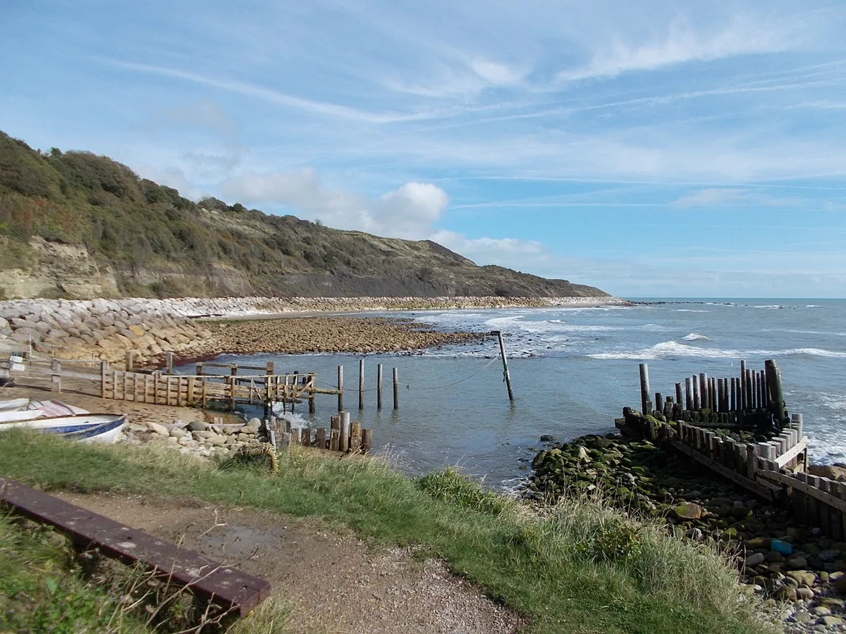
Binnel Bay
Binnel Bay — bay on the south coast of the Isle of Wight, England, UK.

Wikimedia Commons contributors — see linked file page for photographer and licence licence
Plan your visit
- Typical visit
- 3 h–8 h
- Best time of year
- Late spring – early autumn (May–Oct)
- Nearest railway station
- Shanklin · 8.9 km
- Free entry
- Dog-friendly
About
Binnel Bay is a named summit in the United Kingdom. Part of English Channel. Wikidata describes it as: "bay on the south coast of the Isle of Wight, England, UK". Coordinates: 50.5787°, -1.2711°.
Photo gallery
Protected designations
- Site of Special Scientific Interest: Compton Chine to Steephill Cove SSSI
- Area of Outstanding Natural Beauty: Isle Of Wight
Designations sourced from Natural England open data under OGL v3.
From the Wikipedia article
Binnel Bay is a bay on the south coast of the Isle of Wight, England. It lies between the villages of St. Lawrence and Niton. It faces south towards the English Channel, and is just under one mile (1.6 km) in length. It stretches from Binnel Point in the east to Puckaster Cove in the west. The bay is remote with a rocky and exposed shoreline backed by low cliffs and woodlands. It is best viewed from Binnel Point, where the bay can be seen stretching west towards Puckaster Cove, with St Catherine's Lighthouse visible in the distance. Large sections of a now destroyed 19th century seawall can be seen along the shore.
Excerpt from Wikipedia under CC BY-SA 4.0. See the source article linked in Sources below.
Background
History
Archaeological findings from the landslide deposits at Binnel Bay have identified evidence of human activity in this area of the Undercliff dating back to the Neolithic. These finds included a Neolithic soil horizon dated to 2530BC, containing charcoal and the remains of red squirrel, red deer and marine molluscs. Later prehistoric evidence includes midden deposits of Bronze Age to Iron Age date. In 1977 a Paleolithic handaxe of Acheulean style was discovered on land immediately west of Binnel Bay. It is thought the handaxe may have originated from deposits that were originally on the downland above the Undercliff, and were subsequently worked into the landslide complex at a later date.…
Sourced from Wikipedia under CC BY-SA 4.0.
- Coordinates
- 50.5787, -1.2711
- District
- Isle of Wight
- Parish
- Ventnor
- Postcode
- PO38 1XZ
- Parliamentary constituency
- Isle of Wight East
- Nearest railway station
- Shanklin — 8.9 km
Sources
- wikidata: Q282983 (CC0)
- wikipedia: Binnel Bay (CC BY-SA 4.0)
- commons: Headland, Binnel Bay - geograph.org.uk - 389140.jpg (CC BY-SA 4.0)
Other places nearby
Loading nearby places…
Nearby
 📷 5
📷 5Historic houses · South East England
Mirables
Mirables — a Grade II*-listed historic house in england-south-east, United Kingdom.
📷 5Memorials & monuments · South East England
FGB
FGB — a memorial in england-south-east, United Kingdom.
 📷 5
📷 5Follies · South East England
Spindler's Folly
Spindler's Folly — a folly in england-south-east, United Kingdom.
 📷 5
📷 5Mountains & hills · South East England
Reeth Bay
Reeth Bay — bay on the south coast of the Isle of Wight, England, UK.
 📷 5
📷 5Manor houses · South East England
Herveys Farm Niton Manor
Herveys Farm Niton Manor — Grade II listed building-listed manor in england-south-east, United Kingdom.
 📷 5
📷 5Historic churches · South East England
Church of St. John the Baptist, Niton
Church of St. John the Baptist, Niton — church in Niton and Whitwell, Isle of Wight, England, UK.
More mountains in this region
 📷 5
📷 5Mountains & hills · South East England
Alum Bay
Alum Bay is a mountain or hill in the United Kingdom.
 📷 5
📷 5Mountains & hills · South East England
Arish Mell
Arish Mell — bay in Dorset, England.
 📷 5
📷 5Mountains & hills · South East England
Balaclava Bay
Balaclava Bay — bay in Dorset, England.
 📷 5
📷 5Mountains & hills · South East England
Balch Cave
Balch Cave — Cave in Somerset, England.
Frequently asked questions
- Where is Binnel Bay?
- Binnel Bay is in South-East England, United Kingdom (postcode PO38 1XZ), in the parish of Ventnor.
- Is Binnel Bay a protected site?
- Yes — Binnel Bay is part of the Compton Chine to Steephill Cove SSSI Site of Special Scientific Interest and the Isle Of Wight National Landscape (AONB).
- Is Binnel Bay free to visit?
- Yes, Binnel Bay is free to enter.
- How do I get to Binnel Bay?
- Drivers can navigate to postcode PO38 1XZ. It sits within the Isle of Wight East parliamentary constituency.