Castles · Yorkshire & the Humber
Bardsey, West Yorkshire
Bardsey, West Yorkshire, England is a small village in the City of Leeds metropolitan borough, 8 miles (13 km) north east of Leeds city centre. The village is in the LS17 Leeds postcode district. It i

Chris Heaton — CC BY-SA 2.0 via Wikimedia Commons licence
Plan your visit
- Typical visit
- 1.5 h–3 h
- Family-friendly
- Limited wheelchair access
About
Bardsey, West Yorkshire, England is a small village in the City of Leeds metropolitan borough, 8 miles (13 km) north east of Leeds city centre. The village is in the LS17 Leeds postcode district. It is part of the civil parish of Bardsey cum Rigton. The village itself lies just off the A58 road between Leeds and Wetherby. It is a predominantly middle class area with a high proportion of retired residents. Housing is mixed; while most is private, there is council housing situated near Keswick Lane. Facilities include a pub and sports club (with a cricket pitch and two football pitches). Bardsey also has a primary school and an Anglican church.
Photo gallery
From the Wikipedia article
Bardsey, West Yorkshire, England is a small village in the City of Leeds metropolitan borough, 8 miles (13 km) north east of Leeds city centre. The village is in the LS17 Leeds postcode district. It is part of the civil parish of Bardsey cum Rigton. The village itself lies just off the A58 road between Leeds and Wetherby. It is a predominantly middle class area with a high proportion of retired residents. Housing is mixed; while most is private, there is council housing situated near Keswick Lane. Facilities include a pub and sports club (with a cricket pitch and two football pitches). Bardsey also has a primary school and an Anglican church.
Excerpt from Wikipedia under CC BY-SA 4.0. See the source article linked in Sources below.
Background
History
]] Nearby earthworks named Pompocali, in the parish of Scarcroft, are of uncertain origin, but possibly a result of quarrying. A minor Roman road lies alongside it, suggesting that Pompocali results from Roman activity. A motte-and-bailey castle dates back to the time immediately following the Norman conquest. Bardsey also claims the oldest Anglo-Saxon tower church in England, with the tower of All Hallows church dating back to . The Bingley Arms is a public house that claims to be England's oldest public house, and to be recorded in the Domesday Book, although these claims are disputed. Bardsey railway station on the Cross Gates–Wetherby line opened in 1876 and closed in 1964.
Sourced from Wikipedia under CC BY-SA 4.0.
- Coordinates
- 53.8840, -1.4450
- District
- Leeds
- Parish
- Bardsey cum Rigton
- Postcode
- LS17 9BT
- Parliamentary constituency
- Wetherby and Easingwold
Sources
- wikipedia: Bardsey, West Yorkshire (CC BY-SA 4.0)
Other places nearby
Loading nearby places…
Nearby
 📷 5
📷 5Historic houses · Yorkshire & the Humber
The Bingley Arms
The Bingley Arms — a Grade II*-listed historic house in england-yorkshire, United Kingdom.
Caravan parks · Yorkshire & the Humber
Haighfield Caravan Park
Haighfield Caravan Park — a caravan park in england yorkshire.
 📷 3
📷 3Archaeological sites · Yorkshire & the Humber
Pompocali
Pompocali — a archaeological in england-yorkshire, United Kingdom.
Campsites · Yorkshire & the Humber
More Lodge Holiday Park
More Lodge Holiday Park — a campsite in england yorkshire.
Caravan parks · Yorkshire & the Humber
More Lodge Holiday Park
More Lodge Holiday Park — a caravan park in england yorkshire.
 📷 3
📷 3Manor houses · Yorkshire & the Humber
Oaklands Manor
Oaklands Manor — Grade II listed building-listed manor in england-yorkshire, United Kingdom.
More castles in this region
 📷 5
📷 5Castles · Yorkshire & the Humber
Ayton Castle
Ayton Castle — castle in North Yorkshire, England, UK.
 📷 3
📷 3Castles · Yorkshire & the Humber
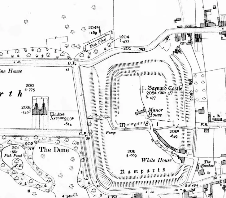
Baynard Castle
Baynard Castle — former moated castle built in the 12th and 13th centuries in the village of Cottingham, East Riding of Yorkshire, England.
 📷 3
📷 3Castles · Yorkshire & the Humber
Bolton Castle
Bolton Castle — 14th-century castle located near Wensleydale, Yorkshire, England.
 📷 3
📷 3Castles · Yorkshire & the Humber
Buttercrambe Castle
Buttercrambe Castle — castle in North Yorkshire, England.
Frequently asked questions
- Where is Bardsey, West Yorkshire?
- Bardsey, West Yorkshire is in Yorkshire, United Kingdom (postcode LS17 9BT), in the parish of Bardsey cum Rigton.
- Does Bardsey, West Yorkshire charge admission?
- Bardsey, West Yorkshire typically charges admission. Check the official site for current ticket prices and opening hours.
- How do I get to Bardsey, West Yorkshire?
- Drivers can navigate to postcode LS17 9BT. It sits within the Wetherby and Easingwold parliamentary constituency.