Natural landmarks · Mid Wales
Bache Hill
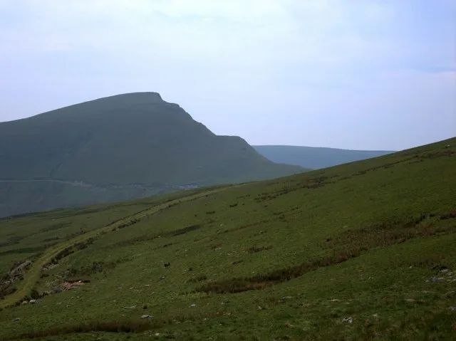
Bache Hill — mountain (610m) in Powys.

Wikimedia Commons contributors — see linked file page for photographer and licence licence
Plan your visit
- Typical visit
- 1 h–2 h
- Nearest railway station
- Dolau · 8.2 km
- Free entry
- Dog-friendly
About
Bache Hill is a named natural landmark in the United Kingdom. Heritage designation: Site of Special Scientific Interest. Wikidata describes it as: "mountain (610m) in Powys". Coordinates: 52.2653°, -3.1533°.
Photo gallery
Protected designations
- Site of Special Scientific Interest: River Teme SSSI
Designations sourced from Natural England open data under OGL v3.
From the Wikipedia article
Bache Hill (Welsh: Bryn Bach) is a subsidiary summit of Rhos Fawr or Great Rhos, in the Radnor Forest in Wales. It is located to the east of Black Mixen. The summit is marked by a trig point built on an ancient burial mound, probably of Bronze Age date, like most of the summit cairns and round barrows in Wales. Some controversy arises from the burial mound; in that 610 metres might be the top of the man-made mound. Some walkers therefore doubt Bache Hill's 2,000-foot status. However, the latest OS Explorer Maps shows a large 610-metre contour round the summit.
Excerpt from Wikipedia under CC BY-SA 4.0. See the source article linked in Sources below.
- Coordinates
- 52.2653, -3.1533
- District
- Powys
- Parish
- New Radnor
- Postcode
- LD8 2TH
- Parliamentary constituency
- Brecon, Radnor and Cwm Tawe
- Nearest railway station
- Dolau — 8.2 km
Sources
- wikidata: Q3378303 (CC0)
- wikipedia: Bache Hill (CC BY-SA 4.0)
- commons: Bache Hill.jpg (CC BY-SA 4.0)
Other places nearby
Loading nearby places…
Nearby
 📷 4
📷 4Forests & woodlands · Mid Wales
Radnor Forest
Radnor Forest in Wales Mid, United Kingdom.
 📷 3
📷 3Mountains & hills · Mid Wales
Whimble
Whimble — a mountain in wales-mid, United Kingdom, 599 m.
Vineyards · Mid Wales
The Whimble
The Whimble — a UK vineyard in wales mid, producing English or Welsh wine from cool-climate grape varieties.
 📷 3
📷 3Mountains & hills · Mid Wales
Great Creigiau
Great Creigiau — a mountain in wales-mid, United Kingdom, 646 m.
 📷 3
📷 3Mountains & hills · Mid Wales
Black Mixen
Black Mixen — Named summit at 650 m.
 📷 3
📷 3Natural landmarks · Mid Wales
Black Mixen
Black Mixen — mountain (650m) in Powys.
More natural landmarks in this region
 Flagship📷 3
Natural landmarks · Mid Wales
Bomere Pool
Bomere Pool — lake in Shropshire, England, UK.
 📷 3
📷 3Natural landmarks · Mid Wales
Craig-y-llyn
Craig-y-llyn — mountain (622m) in Gwynedd, Wales.
 📷 3
📷 3Natural landmarks · Mid Wales
Black Hill
Black Hill — mountain in Herefordshire, England, United Kingdom.
📷 3Natural landmarks · Mid Wales
Black Mixen
Black Mixen — mountain (650m) in Powys.
Frequently asked questions
- Where is Bache Hill?
- Bache Hill is in Mid Wales, United Kingdom (postcode LD8 2TH), in the parish of New Radnor.
- Is Bache Hill a listed building?
- Bache Hill is officially recognised as Site of Special Scientific Interest listed.
- Is Bache Hill a protected site?
- Yes — Bache Hill is part of the River Teme SSSI Site of Special Scientific Interest.
- Is Bache Hill free to visit?
- Yes, Bache Hill is free to enter.
- How do I get to Bache Hill?
- Drivers can navigate to postcode LD8 2TH. It sits within the Brecon, Radnor and Cwm Tawe parliamentary constituency.